
Conical Hill topographic map
Interactive map
Click on the map to display elevation.
About this map
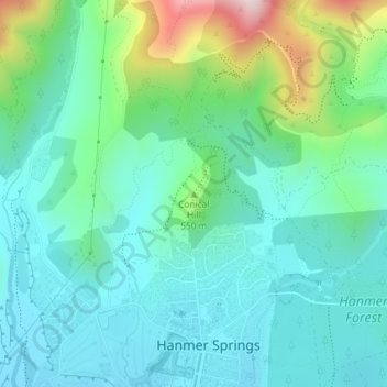
Name: Conical Hill topographic map, elevation, terrain.
Average elevation: 457 m
Minimum elevation: 357 m
Maximum elevation: 790 m
Other topographic maps
Click on a map to view its topography, its elevation and its terrain.
Tasman Glacier
New Zealand > Canterbury > Mackenzie District
At 23.5 kilometres (14.6 mi) in length, Tasman Glacier is still New Zealand's longest glacier, despite shrinking considerably from the 1990s onwards. It is as much as 4 kilometres (2.5 mi) wide and 600 metres (2,000 ft) thick, and lies entirely within the borders of Aoraki / Mount Cook National Park. The…
Average elevation: 1,884 m
Lake Ōhau
New Zealand > Canterbury > Waitaki District
Wilding Pines (Pinus Cortorta, Pinus sylvestris) are problematic on the foreshore of Lake Ōhau. Pinus contorta grow “probably five to 10 times faster” in the Mackenzie Country (and Lake Ōhau) than in their native North America. They can establish themselves at altitudes of up to 2000 metres. Where they…
Average elevation: 904 m
Un named plug
New Zealand > Canterbury > Christchurch City > Banks Peninsula Community > Diamond Harbour
Average elevation: 164 m
Lake Tekapo
New Zealand > Canterbury > Mackenzie District
Lake Tekapo (Māori: Takapō) is the second-largest of three roughly parallel lakes running north–south along the northern edge of the Mackenzie Basin in the South Island of New Zealand (the others are Lake Pukaki and Lake Ōhau). It covers an area of 83 square kilometres (32 sq mi) and is at an altitude of…
Average elevation: 1,025 m
Akaroa
New Zealand > Canterbury > Christchurch City > Banks Peninsula Community
Average elevation: 191 m
Styx Mill Conservation Reserve
New Zealand > Canterbury > Christchurch City > Christchurch
Average elevation: 14 m
New Brighton Beach
New Zealand > Canterbury > Christchurch City > Coastal-Burwood Community
Average elevation: 4 m
Akaroa
New Zealand > Canterbury > Christchurch City > Banks Peninsula Community
Average elevation: 152 m
Queen Elizabeth II Park
New Zealand > Canterbury > Christchurch City > Coastal-Burwood Community
Average elevation: 4 m
Halswell-Hornby-Riccarton Community
New Zealand > Canterbury > Christchurch City
Average elevation: 49 m
Pigeon Bay
New Zealand > Canterbury > Christchurch City > Banks Peninsula Community
Average elevation: 243 m
Linwood-Central-Heathcote Community
New Zealand > Canterbury > Christchurch City
Average elevation: 55 m