Geolocate

Gear up for your next adventure:

As an Amazon Associate, this site earns from qualifying purchases at no extra cost to you.

👉 Easily get elevation data in JSON, GeoTIFF and KML formats using Elevation API
Thank you for supporting this site ❤️
Make a donation

Brunswick County topographic map

Click on the map to display elevation.

Gear up for your next adventure:

As an Amazon Associate, this site earns from qualifying purchases at no extra cost to you.

Gear up for your next adventure:

As an Amazon Associate, this site earns from qualifying purchases at no extra cost to you.

👉 Easily get elevation data in JSON, GeoTIFF and KML formats using Elevation API
Thank you for supporting this site ❤️
Make a donation

About this map

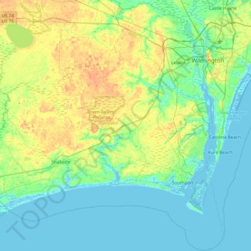
Name: Brunswick County topographic map, elevation, terrain.

Location: Brunswick County, North Carolina, United States (33.75288 -78.65093 34.37198 -77.89701)

Average elevation: 9 m

Minimum elevation: -3 m

Maximum elevation: 29 m

Gear up for your next adventure:

As an Amazon Associate, this site earns from qualifying purchases at no extra cost to you.

👉 Easily get elevation data in JSON, GeoTIFF and KML formats using Elevation API
Thank you for supporting this site ❤️
Make a donation

Other topographic maps

Click on a map to view its topography, its elevation and its terrain.

Appalachian Mountains

United States > North Carolina > Yancey County

The Appalachian Mountains (French: Appalaches), often called the Appalachians, are a system of mountains in eastern to northeastern North America. The Appalachians first formed roughly 480 million years ago during the Ordovician Period. They once reached elevations similar to those of the Alps and the Rocky…

Average elevation: 1,463 m

Gear up for your next adventure:

As an Amazon Associate, this site earns from qualifying purchases at no extra cost to you.

Thank you for supporting this site ❤️
Make a donation

Cane Creek

United States > North Carolina > Union County

Average elevation: 177 m

Gear up for your next adventure:

As an Amazon Associate, this site earns from qualifying purchases at no extra cost to you.

Thank you for supporting this site ❤️
Make a donation

Hubert

United States > North Carolina > Onslow County

Average elevation: 10 m

Highlands

United States > North Carolina > Macon County > Highlands

Highlands was founded in 1875 after its two founders, Samuel Truman Kelsey and Clinton Carter Hutchinson, drew lines from Chicago to Savannah and from New Orleans to New York City. They felt that the place where these lines met would eventually become a great trading center and commercial crossroads. Highlands…

Average elevation: 1,090 m

Elliott

United States > North Carolina > Sampson County

Average elevation: 35 m

Gear up for your next adventure:

As an Amazon Associate, this site earns from qualifying purchases at no extra cost to you.

Thank you for supporting this site ❤️
Make a donation

Mount Mitchell

United States > North Carolina > Yancey County

Mount Mitchell, known in Cherokee as Attakulla, is the highest peak of the Appalachian Mountains and the highest peak in mainland eastern North America. It is located near Burnsville in Yancey County, North Carolina in the Black Mountain subrange of the Appalachians about 19 miles (31 km) northeast of…

Average elevation: 1,743 m

Pelham

United States > North Carolina > Caswell County

Average elevation: 198 m

Candler

United States > North Carolina > Buncombe County

Average elevation: 669 m

Gear up for your next adventure:

As an Amazon Associate, this site earns from qualifying purchases at no extra cost to you.

Thank you for supporting this site ❤️
Make a donation

Bynum

United States > North Carolina > Chatham County

Average elevation: 124 m

Rover

United States > North Carolina > Beaufort County

Average elevation: 11 m

Gear up for your next adventure:

As an Amazon Associate, this site earns from qualifying purchases at no extra cost to you.

Thank you for supporting this site ❤️
Make a donation

Jersey

United States > North Carolina > Davidson County

Average elevation: 202 m

Yorkwood

United States > North Carolina > Gaston County

Average elevation: 225 m

Gear up for your next adventure:

As an Amazon Associate, this site earns from qualifying purchases at no extra cost to you.

Thank you for supporting this site ❤️
Make a donation

Delta

United States > North Carolina > Stokes County

Average elevation: 315 m

Westmoore

United States > North Carolina > Moore County

Average elevation: 163 m

Gear up for your next adventure:

As an Amazon Associate, this site earns from qualifying purchases at no extra cost to you.

Thank you for supporting this site ❤️
Make a donation

Glencoe

United States > North Carolina > Alamance County

Average elevation: 184 m

Newton Bald

United States > North Carolina > Swain County

Average elevation: 1,314 m

Gear up for your next adventure:

As an Amazon Associate, this site earns from qualifying purchases at no extra cost to you.

Thank you for supporting this site ❤️
Make a donation

Bly Gap

United States > North Carolina > Clay County

Average elevation: 1,060 m

Tyre Knob

United States > North Carolina > Graham County

Average elevation: 826 m

Gear up for your next adventure:

As an Amazon Associate, this site earns from qualifying purchases at no extra cost to you.

Thank you for supporting this site ❤️
Make a donation

Crumpler

United States > North Carolina > Ashe County

Average elevation: 838 m

Buffalo

United States > North Carolina > Stokes County

Average elevation: 303 m

Gear up for your next adventure:

As an Amazon Associate, this site earns from qualifying purchases at no extra cost to you.

Thank you for supporting this site ❤️
Make a donation

Kyle

United States > North Carolina > Macon County

Average elevation: 1,074 m

Gear up for your next adventure:

As an Amazon Associate, this site earns from qualifying purchases at no extra cost to you.

Thank you for supporting this site ❤️
Make a donation

Warne

United States > North Carolina > Clay County

Average elevation: 568 m

Topton

United States > North Carolina > Cherokee County

Average elevation: 980 m

Qualla

United States > North Carolina > Jackson County

Average elevation: 628 m

Gear up for your next adventure:

As an Amazon Associate, this site earns from qualifying purchases at no extra cost to you.

Thank you for supporting this site ❤️
Make a donation

Buxton

United States > North Carolina > Dare County

Average elevation: 2 m

Apple Grove

United States > North Carolina > Ashe County

Average elevation: 1,001 m

Gear up for your next adventure:

As an Amazon Associate, this site earns from qualifying purchases at no extra cost to you.

Thank you for supporting this site ❤️
Make a donation

Traphill

United States > North Carolina > Wilkes County

Average elevation: 412 m

Gear up for your next adventure:

As an Amazon Associate, this site earns from qualifying purchases at no extra cost to you.

Thank you for supporting this site ❤️
Make a donation

Stone Mountain

United States > North Carolina > Wilkes County

Stone Mountain is the centerpiece of Stone Mountain State Park in North Carolina. It is a dome of exposed granite (specifically a quartz diorite to granodiorite) of Devonian age, which has intruded into the gneiss of the Precambrian Alligator Back Formation. It rises sharply over 600 feet (183 m) above the…

Average elevation: 567 m

Rich Mountain

United States > North Carolina > Watauga County

Rich Mountain is a mountain located in the North Carolina High Country, roughly 3 miles (4.8 km) northwest of the town of Boone. Its elevation reaches 4,748 feet (1,447 m).

Average elevation: 1,214 m

Gear up for your next adventure:

As an Amazon Associate, this site earns from qualifying purchases at no extra cost to you.

Thank you for supporting this site ❤️
Make a donation

Little Scaly

United States > North Carolina > Macon County

Average elevation: 1,089 m

Linville

United States > North Carolina > Avery County

Average elevation: 1,184 m

Ennice

United States > North Carolina > Alleghany County

Average elevation: 794 m

Gear up for your next adventure:

As an Amazon Associate, this site earns from qualifying purchases at no extra cost to you.

Thank you for supporting this site ❤️
Make a donation

Sheep Cliff

United States > North Carolina > Jackson County

Average elevation: 1,188 m

Hayes

United States > North Carolina > Durham County > Durham

Average elevation: 115 m

Gear up for your next adventure:

As an Amazon Associate, this site earns from qualifying purchases at no extra cost to you.

Thank you for supporting this site ❤️
Make a donation

Cove

United States > North Carolina > Haywood County

Average elevation: 925 m

Waxhaw

United States > North Carolina > Union County

Average elevation: 187 m

Gear up for your next adventure:

As an Amazon Associate, this site earns from qualifying purchases at no extra cost to you.

Thank you for supporting this site ❤️
Make a donation

Low Gap

United States > North Carolina > Yancey County

Average elevation: 994 m

Cowee

United States > North Carolina > Macon County

Average elevation: 646 m

Gear up for your next adventure:

As an Amazon Associate, this site earns from qualifying purchases at no extra cost to you.

Thank you for supporting this site ❤️
Make a donation

Nebo

United States > North Carolina > McDowell County

Average elevation: 394 m

Gear up for your next adventure:

As an Amazon Associate, this site earns from qualifying purchases at no extra cost to you.

Thank you for supporting this site ❤️
Make a donation