
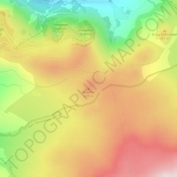
Moelfre topographic map
Interactive map
Click on the map to display elevation.
About this map
Name: Moelfre topographic map, elevation, terrain.
Location: Moelfre, Conwy, Wales, LL34 6EP, United Kingdom (53.25113 -3.92399 53.25123 -3.92389)
Average elevation: 341 m
Minimum elevation: 85 m
Maximum elevation: 560 m
Wales trails, hiking, mountain biking, running and outdoor activities
Other topographic maps
Click on a map to view its topography, its elevation and its terrain.
Pembrokeshire
There is little evidence of Roman occupation in what is now Pembrokeshire. Ptolemy's Geography, written c. 150, mentioned some coastal places, two of which have been identified as the River Teifi and what is now St Davids Head, but most Roman writers did not mention the area; there may have been a Roman…
Average elevation: 43 m
Brecon Beacons National Park
United Kingdom > Wales > Powys
Brecon Beacons National Park, officially named Bannau Brycheiniog National Park (Welsh pronunciation), is a national park in Wales. It is named after the Brecon Beacons (Welsh: Bannau Brycheiniog), the mountain range at its centre. The national park includes the highest mountain in South Wales, Pen y Fan,…
Average elevation: 270 m
Cosmeston Lakes Country Park
United Kingdom > Wales > Vale of Glamorgan > Penarth
Average elevation: 26 m
Rudry Common
United Kingdom > Wales > Caerphilly County Borough > Trethomas > Rudry
Average elevation: 131 m
Torfaen
Exterior A large iron framed market hall with two full elevations and three secondary entrances through other street frontages, eg. Jubilee Building, Crane Street. Built of grey narrow coursed rock faced pennant limestone with some larger stones, and with yellow Ebbw Vale brick dressings and a Welsh slate…
Average elevation: 206 m
Grwyne Fawr Reservoir
United Kingdom > Wales > Powys
By the end of the 19th-century there were serious water shortages in the western parts of the historic county of Monmouthshire. The area had seen a massive population increase as a result of the steel and coal industries but the supply of water to the area was complicated due to its high altitude. A site for a…
Average elevation: 619 m
Preseli Mountains
United Kingdom > Wales > Pembrokeshire > Puncheston
Samuel Lewis's A Topographical Dictionary of Wales published in 1833 said of Maenclochog parish.
Average elevation: 217 m
Parc Tan-y-Bwlch
United Kingdom > Wales > Gwynedd > Mynydd Llandygái > Pen Y Bwlch
Average elevation: 293 m
Maerdy Park
United Kingdom > Wales > Merthyr Tydfil County Borough > Merthyr Tydfil
Average elevation: 223 m