
Beni topographic map
Interactive map
Click on the map to display elevation.
About this map
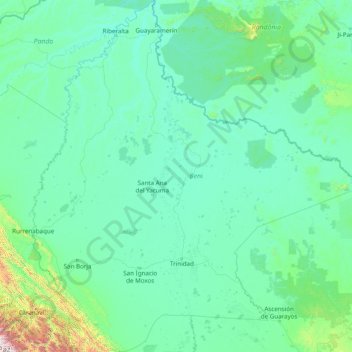
Name: Beni topographic map, elevation, terrain.
Location: Beni, Bolivia (-16.41956 -67.56489 -10.38055 -61.52812)
Average elevation: 255 m
Minimum elevation: 108 m
Maximum elevation: 5,234 m
Other topographic maps
Click on a map to view its topography, its elevation and its terrain.
La Paz
Bolivia > La Paz > Pedro Domingo Murillo > La Paz
The city, in west-central Bolivia 68 km (42 mi) southeast of Lake Titicaca, is set in a canyon created by the Choqueyapu River. It is in a bowl-like depression, part of the Amazon basin, surrounded by the high mountains of the Altiplano. Overlooking the city is the towering, triple-peaked Illimani. Its peaks…
Average elevation: 4,087 m
Urubo
Bolivia > Santa Cruz > Provincia Andrés Ibáñez > Municipio Porongo (Ayacucho)
Average elevation: 415 m
Santiago de Machaca
Bolivia > La Paz > Provincia General José Manuel Pando > Municipio Santiago de Machaca
Average elevation: 3,873 m
Cachuela Esperanza
Bolivia > Beni > Guayaramerín
Cachuela Esperanza ("rapids of hope") is situated on the right bank at the rapids of Beni River, 30 km before its confluence with Mamoré River which both form the Madeira River there. The village is only accessible on dirt roads and is located at an elevation of 134 m.
Average elevation: 121 m
Santiago de Huata
Bolivia > La Paz > Provincia Omasuyos > Municipio Santiago de Huata
Average elevation: 3,911 m
Samaipata
Bolivia > Santa Cruz > Provincia Florida > Municipio Samaipata
Samaipata or Samaypata (Quechua samay to rest, pata elevated place / above, at the top / edge, bank (of a river), shore) is a small town in the Florida Province of the Santa Cruz Department in Bolivia. It has a subtropical climate and an altitude of 1600–1800 m. It lies about 120 kilometers to the southwest…
Average elevation: 1,695 m
Nevado Sajama
Bolivia > Oruro > Sajama > Curahuara de Carangas
The mountain is covered by an ice cap, and Polylepis tarapacana trees occur up to 5,000 metres (16,000 ft) elevation.
Average elevation: 5,771 m
Oruro
Bolivia > Oruro > Provincia Cercado
Oruro lies north of the salty lakes Uru Uru and Poopó. It is three hours (by vehicle) from La Paz. Located at an altitude of 3709 meters above sea level, Oruro is well known for its cold weather. Warmer temperatures generally take place during August, September and October, after the worst of the winter…
Average elevation: 3,751 m
Morning Sun
Bolivia > Potosí > Provincia Sur Lípez > Municipio San Pablo de Lipez
Sol de Mañana is an area with geothermal manifestations in southern Bolivia, including fumaroles, hot springs and mud pools. It lies at about 4,900 metres (16,100 ft) elevation, south of Laguna Colorada and east of El Tatio geothermal field. The field is located within the Eduardo Avaroa Andean Fauna National…
Average elevation: 4,894 m
Jorochito
Bolivia > Santa Cruz > Provincia Andrés Ibáñez > Municipio El Torno
Average elevation: 578 m
Sucre
Bolivia > Chuquisaca > Provincia Oropeza
Sucre (Spanish: [ˈsukɾe]) is the de jure capital city of Bolivia, the capital of the Chuquisaca Department and the sixth most populous city in Bolivia. Located in the south-central part of the country, Sucre lies at an elevation of 2,790 m (9,150 ft). This relatively high altitude gives the city a…
Average elevation: 2,829 m
San Agustin
Bolivia > Potosí > Provincia Enrique Baldivieso > Municipio San Agustin
Average elevation: 3,900 m
Huayllajara
Bolivia > Potosí > Provincia José Maria Linares > Municipio Puna
Average elevation: 3,417 m
Bella Vista
Bolivia > Oruro > Provincia Nor Carangas > Municipio Santiago de Huayllamarca
Average elevation: 3,836 m
Atlantico Norte
Bolivia > Santa Cruz > Velasco > Municipio San Miguel de Velasco
Average elevation: 305 m
Laguna Esmeralda de Quirusillas
Bolivia > Santa Cruz > Provincia Florida > Municipio Quirusillas
Average elevation: 2,070 m
Camargo
Bolivia > Chuquisaca > Provincia Nor Cinti > Municipio Camargo
Camargo is the capital of Nor Cinti Province and is situated in Camargo Municipio, embedded between north-southerly mountain ridges, at an elevation of 2,414 m, on the banks of Río Chico which later becomes Río Pilaya.
Average elevation: 2,499 m
Copacabana
Bolivia > La Paz > Provincia Manco Kapac
Copacabana has a dry-winter subpolar oceanic climate (Cwb), a rare variant of this type of climate, but commonplace near most of Lake Titicaca. Similar to many areas with this climate, Copacabana features a markedly drier "low-sun" season. Because of the high altitude of Copacabana, the town is chilly…
Average elevation: 3,864 m
Junta Pirai
Bolivia > Santa Cruz > Provincia Andrés Ibáñez > Municipio El Torno
Average elevation: 538 m
Santiago de Huata
Bolivia > La Paz > Provincia Omasuyos > Municipio Santiago de Huata
Average elevation: 3,911 m
Puerto Limon
Bolivia > Santa Cruz > Provincia Florida > Municipio Samaipata
Average elevation: 1,457 m
Samaipata
Bolivia > Santa Cruz > Provincia Florida > Municipio Samaipata
Samaipata or Samaypata (Quechua samay to rest, pata elevated place / above, at the top / edge, bank (of a river), shore) is a small town in the Florida Province of the Santa Cruz Department in Bolivia. It has a subtropical climate and an altitude of 1600–1800 m. It lies about 120 kilometers to the southwest…
Average elevation: 1,695 m
Huayllajara
Bolivia > Tarija > Provincia de José María Avilés > Municipio Yunchará
Average elevation: 3,887 m
Alota
Bolivia > Potosí > Provincia Enrique Baldivieso > Municipio San Agustin
Average elevation: 3,816 m
Millares
Bolivia > Potosí > Provincia Cornelio Saavedra > Municipio Betanzos
Average elevation: 2,456 m
Sullka Uta Manasaya
Bolivia > Oruro > Provincia Sajama > Municipio Curahuara de Carangas
Average elevation: 4,065 m
Tunupa
Bolivia > Oruro > Ladislao Cabrera > Salinas de Garcí Mendoza
It stands on the northern side of the Salar de Uyuni at an elevation of 5,321 m (17,457 ft) on the Bolivian Altiplano. Tunupa was active in the Pleistocene, with most of the volcano constructed by lava flows that erupted between 1.36 and 1.56 million years ago. Later glaciers developed on the mountain.
Average elevation: 4,826 m
Provincia Manuel María Caballero
Bolivia > Santa Cruz > Provincia Manuel M. Caballero > Municipio Comarapa
Average elevation: 2,306 m
Quetena Chico
Bolivia > Potosí > Provincia Sur Lípez > Municipio San Pablo de Lipez > Quetena Chico
Average elevation: 4,196 m
Estancia San Sabastian
Bolivia > Santa Cruz > Provincia Ángel Sandóval > Municipio San Matías > Estancia San Sabastian
Average elevation: 126 m