
Church Lench topographic map
Interactive map
Click on the map to display elevation.
About this map
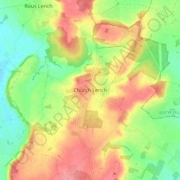
Name: Church Lench topographic map, elevation, terrain.
Average elevation: 79 m
Minimum elevation: 38 m
Maximum elevation: 120 m
Worcestershire trails, hiking, mountain biking, running and outdoor activities
Other topographic maps
Click on a map to view its topography, its elevation and its terrain.
Badsey Lane Nature Reserve
United Kingdom > England > Worcestershire > Wychavon > Evesham
Average elevation: 37 m
Hartlebury Common Local Nature Reserve
United Kingdom > England > Worcestershire > Wychavon > Hartlebury
Average elevation: 39 m
Upton Warren
United Kingdom > England > Worcestershire > Wychavon > Upton Warren
Average elevation: 78 m