
Umbria topographic map
Interactive map
Click on the map to display elevation.
About this map
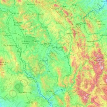
Name: Umbria topographic map, elevation, terrain.
Location: Umbria, Italy (42.36478 11.89203 43.61734 13.26419)
Average elevation: 521 m
Minimum elevation: 15 m
Maximum elevation: 2,445 m
Umbria is bordered by Tuscany to the west and the north, Marche to the east and Lazio to the south. Partly hilly and mountainous, and partly flat and fertile owing to the valley of the Tiber, its topography includes part of the central Apennines, with the highest point in the region at Monte Vettore on the border of the Marche, at 2,476 metres (8,123 feet); the lowest point is Attigliano, 96 metres (315 feet). It is the only Italian region having neither a coastline nor a common border with other countries. The comune of Città di Castello has an exclave named Monte Ruperto within Marche. Contained within Umbria is the hamlet of Cospaia, which was a tiny republic from 1440 to 1826, created by accident.
Other topographic maps
Click on a map to view its topography, its elevation and its terrain.
Pula
Italy > Sardinia > Casteddu/Cagliari
Pula, Casteddu/Cagliari, Sardinia, 09010, Italy
Average elevation: 89 m
Bell'Italia
Italy > Emilia-Romagna > Modena > Maranello
Bell'Italia, Maranello, Unione dei comuni del Distretto Ceramico, Modena, Emilia-Romagna, 41053, Italy
Average elevation: 117 m
Alfianello
Alfianello, Brescia, Lombardy, 25020, Italy
Average elevation: 49 m
Monte Narbone
Italy > Sicily > Agrigento > Agrigento
Monte Narbone, Agrigento, Sicily, 92100, Italy
Average elevation: 302 m
Mara Arbarei/Villamar
Mara Arbarei/Villamar, Sud Sardegna, Sardinia, 09020, Italy
Average elevation: 152 m
Fioranello
Italy > Lazio > Roma Capitale > Rome
Fioranello, Municipio Roma VIII, Rome, Roma Capitale, Lazio, 00043, Italy
Average elevation: 105 m
Trieste
Italy > Friuli-Venezia Giulia > Trieste
Trieste, Friuli-Venezia Giulia, 34121-34151, Italy
Average elevation: 184 m
Deximumannu/Decimomannu
Italy > Sardinia > Casteddu/Cagliari
Deximumannu/Decimomannu, Casteddu/Cagliari, Sardinia, 09033, Italy
Average elevation: 20 m
Corricella
Italy > Campania > Napoli > Procida
Corricella, Procida, Napoli, Campania, 80079, Italy
Average elevation: 6 m
Peschiera del Garda
Peschiera del Garda, Verona, Veneto, 37019, Italy
Average elevation: 86 m
Sommacampagna
Sommacampagna, Verona, Veneto, 37066, Italy
Average elevation: 90 m
Bolzano - Bozen
Italy > Trentino-Alto Adige/Südtirol > South Tyrol
Bolzano - Bozen, South Tyrol, Trentino-Alto Adige/Südtirol, 39100, Italy
Average elevation: 716 m
Unione dei Comuni Amiata Val d'Orcia
Unione dei Comuni Amiata Val d'Orcia, Siena, Tuscany, Italy
Average elevation: 512 m
Castagnola
Italy > Umbria > Perugia > Giano dell'Umbria
Castagnola, Giano dell'Umbria, Perugia, Umbria, 06030, Italy
Average elevation: 489 m
Maranello
Italy > Emilia-Romagna > Modena
Maranello, Unione dei comuni del Distretto Ceramico, Modena, Emilia-Romagna, 41053, Italy
Average elevation: 220 m
Zola Predosa
Italy > Emilia-Romagna > Bologna
Zola Predosa, Unione dei comuni Valli del Reno, Lavino e Samoggia, Bologna, Emilia-Romagna, 40069, Italy
Average elevation: 97 m
Villaggio Monte Cucco
Italy > Veneto > Verona > Ferrara di Monte Baldo
Villaggio Monte Cucco, Ferrara di Monte Baldo, Verona, Veneto, 37020, Italy
Average elevation: 879 m
Cineto Romano
Italy > Lazio > Roma Capitale
Cineto Romano, Roma Capitale, Lazio, Italy
Average elevation: 612 m
Parco del Colle Oppio
Italy > Lazio > Roma Capitale > Rome
Parco del Colle Oppio, Municipio Roma I, Rome, Roma Capitale, Lazio, Italy
Average elevation: 48 m
Madonna della Neve
Italy > Piedmont > Cuneo > Clavesana
Madonna della Neve, Clavesana, Cuneo, Piedmont, 12061, Italy
Average elevation: 329 m