
Champéry topographic map
Interactive map
Click on the map to display elevation.
About this map
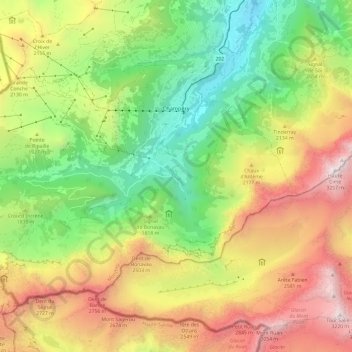
Name: Champéry topographic map, elevation, terrain.
Location: Champéry, Monthey, Wallis, 1874, Switzerland (46.12927 6.79029 46.19007 6.91014)
Average elevation: 1,883 m
Minimum elevation: 820 m
Maximum elevation: 3,251 m
The Champéry – Planachaux cable-car (125 passengers) and the new 6 seater chairlift in Grand-Paradis takes skiers to the Portes du Soleil recreational area, at an altitude of 2,000 m (6,600 ft). With 194 ski lifts and over 650 km (400 mi) of ski slopes, this is the largest international ski area in the world.
Other topographic maps
Click on a map to view its topography, its elevation and its terrain.
Val-d'Illiez
Switzerland > Wallis > Monthey
Val-d'Illiez, Monthey, Wallis, 1873, Switzerland
Average elevation: 1,672 m
Lac de Taney
Switzerland > Wallis > Monthey > Vouvry > Taney
Lac de Taney, Taney, Vouvry, Monthey, Wallis, 1896, Switzerland
Average elevation: 1,430 m
Troistorrents
Switzerland > Wallis > Monthey
Troistorrents, Monthey, Wallis, Switzerland
Average elevation: 1,231 m
Saint-Gingolph
Switzerland > Wallis > Monthey > Saint-Gingolph
Saint-Gingolph, Monthey, Wallis, 1898, Switzerland
Average elevation: 1,104 m