
Long Island topographic map
Click on the map to display elevation.
Long Island
Long Island’s topography is a low, elongated glacial landscape, shaped less by bedrock relief than by the deposits left at the southern margin of the last ice sheets. Its main relief is organized around two broad terminal-moraine belts—the Harbor Hill moraine along much of the North Shore and the Ronkonkoma moraine through the island’s interior—which form gently rolling ridges of sand, gravel, and till, while the land southward grades into flatter sandy outwash plains and barrier-beach systems facing the Atlantic. Elevations are modest overall, rising from sea level along Long Island Sound, the bays, and the ocean beaches to the island’s highest natural ground at Jayne’s Hill, about 401 feet (122 meters), in the West Hills area. The North Shore is generally more irregular, with short valleys, bluffs, and locally steep slopes descending toward the Sound, whereas the South Shore is broader, lower, and smoother, marked by wetlands, lagoons, tidal inlets, and long barrier islands. Overall, Long Island presents the physical character of a subdued but distinctly glacial coastal plain: gently undulating inland ridges, sandy aquifer-bearing deposits, low coastal flats, and a shoreline shaped by the contrast between moraine-built northern terrain and wave-reworked southern beaches.
About this map
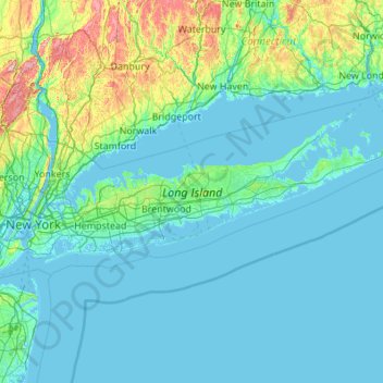
Name: Long Island topographic map, elevation, terrain.
Location: Long Island, New York, United States (40.54190 -74.04197 41.16116 -71.85627)
Average elevation: 42 m
Minimum elevation: -5 m
Maximum elevation: 498 m
Other topographic maps
Click on a map to view its topography, its elevation and its terrain.
Tug Hill
United States > New York > Oswego County
The core Tug Hill region encompasses 150,000 acres (610 km2) of unbroken, generally second-growth, northern hardwood forest, and is drained by a vast network of streams. Important rivers and streams whose headwaters are located within the Tug Hill region include the Mohawk River, Deer River, Salmon River, Mad…
Average elevation: 109 m
Central Park
United States > New York > New York County > New York
In June 1856, Fernando Wood appointed a "consulting board" of seven people, headed by author Washington Irving, to inspire public confidence in the proposed development. Wood hired military engineer Egbert Ludovicus Viele as the park's chief engineer, tasking him with a topographical survey of the site. The…
Average elevation: 26 m
Sonyea State Forest
United States > New York > Livingston County > Town of Mount Morris
Average elevation: 231 m
Riverside Park
United States > New York > New York County > New York
Initially, Riverside Avenue had been planned to run in a straight line, which would have required a retaining wall and extensive fill. However, the area's difficult topography had come to the attention of the Manhattan park commissioners. In 1873, the commissioners selected Frederick Law Olmsted, a park…
Average elevation: 17 m
South Salem
United States > New York > Westchester County > Town of Lewisboro
Average elevation: 174 m
Mariandale
United States > New York > Westchester County > Village of Ossining
Average elevation: 53 m
Central Park
United States > New York > New York County > New York
In June 1856, Fernando Wood appointed a "consulting board" of seven people, headed by author Washington Irving, to inspire public confidence in the proposed development. Wood hired military engineer Egbert Ludovicus Viele as the park's chief engineer, tasking him with a topographical survey of the site. The…
Average elevation: 26 m
Inwood Hill Park
United States > New York > New York County > New York
Inwood Hill Park is a 196 acres (79 ha) public park in the Inwood neighborhood of Manhattan, New York City, operated by the New York City Department of Parks and Recreation. On a high schist ridge that rises 200 feet (61 m) above the Hudson River from Dyckman Street to the northern tip of the island, Inwood…
Average elevation: 14 m
Boyntonville
United States > New York > Rensselaer County > Town of Pittstown
Average elevation: 202 m
Snug Harbor Cultural Center and Botanical Garden
United States > New York > New York
Building C, also known as the Administration Building, was completed in 1833 and is Lafever's oldest surviving work. As of 2020, building C houses part of the Newhouse Center for Contemporary Art. The building consists of two stories, a raised basement, and an attic; it is rectangular in plan with a gable…
Average elevation: 20 m
Whitesville
United States > New York > Allegany County > Town of Independence
Average elevation: 611 m
Potter Hollow
United States > New York > Albany County > Town of Rensselaerville
Average elevation: 346 m
Hartmans Corners
United States > New York > Albany County > Town of Guilderland
Average elevation: 81 m
Pleasantside
United States > New York > Westchester County > Town of Cortlandt
Average elevation: 108 m
Brick House Corners
United States > New York > Genesee County > Town of Pembroke
Average elevation: 262 m
Middle Granville
United States > New York > Washington County > Town of Granville
Average elevation: 156 m
Brooklyn Bridge Park
United States > New York > Kings County > New York
Brooklyn Bridge Park spans 85 acres (34 ha) of the East River waterfront in the Brooklyn Heights and Dumbo neighborhoods of Brooklyn. The park is divided into eleven sections: Piers 1 through 6; Fulton Ferry Landing; Brooklyn Bridge Plaza; Empire Fulton Ferry; Main Street; and John Street. Each of these…
Average elevation: 9 m
Catamount Mountain
United States > New York > Saint Lawrence County > Town of Colton
Average elevation: 433 m
Oscawana Corners
United States > New York > Putnam County > Town of Putnam Valley
Average elevation: 158 m
Woodcock Mountain
United States > New York > Saratoga County > Town of Hadley
Average elevation: 271 m
Constantia Center
United States > New York > Oswego County > Town of Constantia
Average elevation: 169 m
South New Berlin
United States > New York > Chenango County > Town of New Berlin
Average elevation: 380 m
Coney Island
United States > New York > Saint Lawrence County > Town of Pierrepont
Average elevation: 174 m