
Make a donation
Gear up for your next adventure:
As an Amazon Associate, this site earns from qualifying purchases at no extra cost to you.
Watauga County topographic map
Click on the map to display elevation.
Make a donation
Gear up for your next adventure:
As an Amazon Associate, this site earns from qualifying purchases at no extra cost to you.
Watauga County
Watauga County is extremely mountainous, and all of the county's terrain is located within the Appalachian Mountains range. The highest point in the county is Calloway Peak, the highest peak of Grandfather Mountain (shared with the adjacent counties of Avery and Caldwell), which rises to 5,964 feet (1,818 meters) above sea level. At an elevation of 5,506 feet (1,678 meters) above sea level, Beech Mountain is the highest incorporated community east of the Mississippi River. Boone, the county's largest city and county seat, has the highest elevation (3,333 feet) of any city over 10,000 population in the Eastern United States.
Make a donation
Gear up for your next adventure:
As an Amazon Associate, this site earns from qualifying purchases at no extra cost to you.
About this map
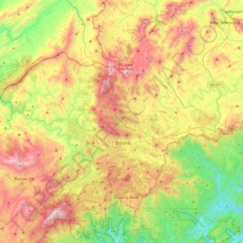
Name: Watauga County topographic map, elevation, terrain.
Location: Watauga County, North Carolina, United States (36.11147 -81.91812 36.39129 -81.45580)
Average elevation: 984 m
Minimum elevation: 378 m
Maximum elevation: 1,777 m
Make a donation
Gear up for your next adventure:
As an Amazon Associate, this site earns from qualifying purchases at no extra cost to you.
Other topographic maps
Click on a map to view its topography, its elevation and its terrain.
Appalachian Mountains
United States > North Carolina > Yancey County
The Appalachian Mountains (French: Appalaches), often called the Appalachians, are a system of mountains in eastern to northeastern North America. The Appalachians first formed roughly 480 million years ago during the Ordovician Period. They once reached elevations similar to those of the Alps and the Rocky…
Average elevation: 1,463 m
Cape Hatteras
United States > North Carolina > Dare County
Cape Hatteras /ˈhætərəs/ is a bend in a thin, broken strand of islands in North Carolina that arch out into the Atlantic Ocean away from the US mainland, then back toward the mainland, creating a series of sheltered islands between the Outer Banks and the mainland. For thousands of years these barrier…
Average elevation: 1 m
Make a donation
Gear up for your next adventure:
As an Amazon Associate, this site earns from qualifying purchases at no extra cost to you.
Long Leaf Acres
United States > North Carolina > New Hanover County > Wilmington
Average elevation: 11 m
Make a donation
Gear up for your next adventure:
As an Amazon Associate, this site earns from qualifying purchases at no extra cost to you.
Lake Raleigh
United States > North Carolina > Wake County > Raleigh > Isle Forest
Average elevation: 104 m
Valle Crucis
United States > North Carolina > Watauga County
Valle Crucis is located at the banks of Dutch Creek and Watauga River, at an elevation of 2,677 feet (816 m) above sea level. To its north and east is Tester Mountain and to its south and west is Valle Mountain. The community is also within the Pisgah National Forest boundary, which limits some development in…
Average elevation: 904 m
Make a donation
Gear up for your next adventure:
As an Amazon Associate, this site earns from qualifying purchases at no extra cost to you.
Make a donation
Gear up for your next adventure:
As an Amazon Associate, this site earns from qualifying purchases at no extra cost to you.
Make a donation
Gear up for your next adventure:
As an Amazon Associate, this site earns from qualifying purchases at no extra cost to you.
Make a donation
Gear up for your next adventure:
As an Amazon Associate, this site earns from qualifying purchases at no extra cost to you.
Make a donation
Gear up for your next adventure:
As an Amazon Associate, this site earns from qualifying purchases at no extra cost to you.
Terrell
United States > North Carolina > Catawba County
Terrell is located at 35°35′20.72″N 80°58′39.5″W / 35.5890889°N 80.977639°W / 35.5890889; -80.977639 within area code 828, ZIP code 28682, and FIPS place code 67180. It sits at an elevation of 289 m (948 ft).
Average elevation: 247 m
Make a donation
Gear up for your next adventure:
As an Amazon Associate, this site earns from qualifying purchases at no extra cost to you.
Make a donation
Gear up for your next adventure:
As an Amazon Associate, this site earns from qualifying purchases at no extra cost to you.
Make a donation
Gear up for your next adventure:
As an Amazon Associate, this site earns from qualifying purchases at no extra cost to you.
Make a donation
Gear up for your next adventure:
As an Amazon Associate, this site earns from qualifying purchases at no extra cost to you.
Mount Mitchell
United States > North Carolina > Yancey County
Mount Mitchell, known in Cherokee as Attakulla, is the highest peak of the Appalachian Mountains and the highest peak in mainland eastern North America. It is located near Burnsville in Yancey County, North Carolina; in the Black Mountain subrange of the Appalachians, about 19 miles (31 km) northeast of…
Average elevation: 1,743 m
Make a donation
Gear up for your next adventure:
As an Amazon Associate, this site earns from qualifying purchases at no extra cost to you.
Make a donation
Gear up for your next adventure:
As an Amazon Associate, this site earns from qualifying purchases at no extra cost to you.
Make a donation
Gear up for your next adventure:
As an Amazon Associate, this site earns from qualifying purchases at no extra cost to you.
Providence Plantation
United States > North Carolina > Mecklenburg County > Charlotte
Average elevation: 205 m
Make a donation
Gear up for your next adventure:
As an Amazon Associate, this site earns from qualifying purchases at no extra cost to you.
Reedy Creek Regional Park
United States > North Carolina > Mecklenburg County > Charlotte
Average elevation: 229 m
Make a donation
Gear up for your next adventure:
As an Amazon Associate, this site earns from qualifying purchases at no extra cost to you.
Make a donation
Gear up for your next adventure:
As an Amazon Associate, this site earns from qualifying purchases at no extra cost to you.
Cul Res Town Creek Indian Mound
United States > North Carolina > Montgomery County
Average elevation: 71 m
Make a donation
Gear up for your next adventure:
As an Amazon Associate, this site earns from qualifying purchases at no extra cost to you.
Wilmington Beach
United States > North Carolina > New Hanover County > Carolina Beach
Average elevation: 2 m
Make a donation
Gear up for your next adventure:
As an Amazon Associate, this site earns from qualifying purchases at no extra cost to you.
Make a donation
Gear up for your next adventure:
As an Amazon Associate, this site earns from qualifying purchases at no extra cost to you.
Tuckaseegee Park
United States > North Carolina > Mecklenburg County > Charlotte
Average elevation: 233 m
Make a donation
Gear up for your next adventure:
As an Amazon Associate, this site earns from qualifying purchases at no extra cost to you.
Maplewood
United States > North Carolina > Richmond County > Rockingham > East Rockingham
Average elevation: 83 m
Make a donation
Gear up for your next adventure:
As an Amazon Associate, this site earns from qualifying purchases at no extra cost to you.
Ballantyne's Backyard
United States > North Carolina > Mecklenburg County > Charlotte
Average elevation: 183 m
Make a donation
Gear up for your next adventure:
As an Amazon Associate, this site earns from qualifying purchases at no extra cost to you.
Make a donation
Gear up for your next adventure:
As an Amazon Associate, this site earns from qualifying purchases at no extra cost to you.
Haw Creek Park
United States > North Carolina > Buncombe County > Asheville > Dogwood Grove
Average elevation: 666 m
Parmele Isles
United States > North Carolina > New Hanover County > Wrightsville Beach
Average elevation: 1 m
Make a donation
Gear up for your next adventure:
As an Amazon Associate, this site earns from qualifying purchases at no extra cost to you.