
Make a donation
Gear up for your next adventure:
As an Amazon Associate, this site earns from qualifying purchases at no extra cost to you.
Galicia topographic map
Click on the map to display elevation.
Make a donation
Gear up for your next adventure:
As an Amazon Associate, this site earns from qualifying purchases at no extra cost to you.
Galicia
The interior of Galicia is characterized by a hilly landscape; mountain ranges rise to 2,000 m (6,600 ft) in the east and south. The coastal areas are mostly an alternate series of rias and beaches. The climate of Galicia is usually temperate and rainy, with markedly drier summers; it is usually classified as Oceanic. Its topographic and climatic conditions have made animal husbandry and farming the primary source of Galicia's wealth for most of its history, allowing for a relatively high density of population. Except shipbuilding and food processing, Galicia was based on a farming and fishing economy until after the mid-20th century, when it began to industrialize. In 2018, the nominal gross domestic product was €62.900 billion, with a nominal GDP per capita of €23,300. Galicia is characterised, unlike other Spanish regions, by the absence of a metropolis dominating the territory. Indeed, the urban network is made up of 7 main cities (the four provincial capitals A Coruña, Pontevedra, Ourense and Lugo, the political capital Santiago de Compostela and the industrial cities Vigo and Ferrol and other small towns. The population is largely concentrated in two main areas: from Ferrol to A Coruña on the northern coast, and in the Rías Baixas region in the southwest, including the cities of Vigo, Pontevedra, and the interior city of Santiago de Compostela. There are smaller populations around the interior cities of Lugo and Ourense. The political capital is Santiago de Compostela, in the province of A Coruña. Vigo, in the province of Pontevedra, is the largest municipality in Galicia and also the most populated city. Two languages are official and widely used today in Galicia: the native Galician, a Romance language closely related to Portuguese with which it shares the Galician-Portuguese medieval literature; and Spanish, usually called Castilian. While most Galicians are bilingual, a 2013 survey reported that 51% of the Galician population spoke Galician most often on a day-to-day basis, while 48% most often used Spanish.
Make a donation
Gear up for your next adventure:
As an Amazon Associate, this site earns from qualifying purchases at no extra cost to you.
About this map
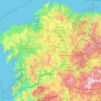
Name: Galicia topographic map, elevation, terrain.
Location: Galicia, Spain (41.80736 -9.30154 43.79042 -6.73395)
Average elevation: 456 m
Minimum elevation: -2 m
Maximum elevation: 2,088 m
Make a donation
Gear up for your next adventure:
As an Amazon Associate, this site earns from qualifying purchases at no extra cost to you.
Other topographic maps
Click on a map to view its topography, its elevation and its terrain.
Picos de Europa
The Picos de Europa ("Peaks of Europe", also the Picos) are a mountain range extending for about 20 km (12 mi), forming part of the Cantabrian Mountains in northern Spain. The range is situated in the Autonomous Communities of Asturias, Cantabria and Castile and León. The highest peak is Torre de Cerredo, at…
Average elevation: 2,290 m
Make a donation
Gear up for your next adventure:
As an Amazon Associate, this site earns from qualifying purchases at no extra cost to you.
Make a donation
Gear up for your next adventure:
As an Amazon Associate, this site earns from qualifying purchases at no extra cost to you.
Santiago de Compostela
The cathedral borders the main plaza of the old and well-preserved city. According to medieval legend, the remains of the apostle James were brought to Galicia for burial; in 813, the light of a bright star guided a shepherd who was watching his flock at night to the burial site in Santiago de Compostela. This…
Average elevation: 248 m
Make a donation
Gear up for your next adventure:
As an Amazon Associate, this site earns from qualifying purchases at no extra cost to you.
Parc de Joan Cluselles i Teixé
Spain > Catalonia > Vallès Oriental > Cardedeu
Average elevation: 224 m
Make a donation
Gear up for your next adventure:
As an Amazon Associate, this site earns from qualifying purchases at no extra cost to you.
Pyrenees
The Pyrenees (/ˈpɪrɪniːz/; Spanish: Pirineos [piɾiˈneos]; French: Pyrénées [piʁene] (listen); Catalan: Pirineu [piɾiˈnɛw]; Basque: Pirinioak [piɾini.o.ak]; Occitan: Pirenèus [piɾeˈnɛws]; Aragonese: Pirineus) is a mountain range straddling the border of France and Spain. It extends nearly 500…
Average elevation: 491 m
Make a donation
Gear up for your next adventure:
As an Amazon Associate, this site earns from qualifying purchases at no extra cost to you.
Sierra de Guadarrama
The range runs southwest–northeast, extending from the province of Ávila in the southwest, through the Community of Madrid, to the province of Segovia in the northeast. The range measures approximately 80 kilometres (50 mi) in length. Its highest peak is Peñalara, 2,428 metres (7,966 ft) in elevation.
Average elevation: 1,235 m
Make a donation
Gear up for your next adventure:
As an Amazon Associate, this site earns from qualifying purchases at no extra cost to you.
African Elephant, Water Buffalo and Southern Lechwe
Spain > Cantabria > Penagos > Cabárceno
Average elevation: 191 m
Hacienda del Álamo
Spain > Region of Murcia > Campo de Cartagena y Mar Menor > Fuente Álamo de Murcia
Average elevation: 185 m
Make a donation
Gear up for your next adventure:
As an Amazon Associate, this site earns from qualifying purchases at no extra cost to you.
Make a donation
Gear up for your next adventure:
As an Amazon Associate, this site earns from qualifying purchases at no extra cost to you.
Pyrenees
The Pyrenees (/ˈpɪrɪniːz/; Spanish: Pirineos [piɾiˈneos]; French: Pyrénées [piʁene] (listen); Catalan: Pirineu [piɾiˈnɛw]; Basque: Pirinioak [piɾini.o.ak]; Occitan: Pirenèus [piɾeˈnɛws]; Aragonese: Pirineus) is a mountain range straddling the border of France and Spain. It extends nearly 500…
Average elevation: 491 m
Málaga
Spain > Andalusia > Málaga-Costa del Sol > Málaga
Like many of the military fortifications that were constructed in Islamic Spain, the Alcazaba of Málaga featured a quadrangular plan. It was protected by an outer and inner wall, both supported by rectangular towers, between which a covered walkway led up the slope to the Gibralfaro (this was the only…
Average elevation: 215 m
Paseo Marítimo de la Bahia de Sant Antoni de Portmany
Spain > Balearic Islands > Ibiza > Sant Antoni de Portmany
Average elevation: 11 m
Make a donation
Gear up for your next adventure:
As an Amazon Associate, this site earns from qualifying purchases at no extra cost to you.
Picos de Europa
The Picos de Europa ("Peaks of Europe", also the Picos) are a mountain range extending for about 20 km (12 mi), forming part of the Cantabrian Mountains in northern Spain. The range is situated in the Autonomous Communities of Asturias, Cantabria and Castile and León. The highest peak is Torre de Cerredo, at…
Average elevation: 2,290 m
Puig Major
Spain > Balearic Islands > Serra de Tramuntana > Escorca
Puig Major is the highest peak on the Spanish island of Majorca. With an elevation of 1,436 m (4,711 ft) above sea level. It is situated in the Serra de Tramuntana mountains. As the mountain is located in a military zone, the neighbouring peak Puig de Massanella (1,364 m) is considered the highest accessible…
Average elevation: 949 m
Make a donation
Gear up for your next adventure:
As an Amazon Associate, this site earns from qualifying purchases at no extra cost to you.
Pico del Teide
Teide, or Mount Teide, (Spanish: El Teide, Pico del Teide, pronounced [ˈpiko ðel ˈtejðe], "Peak of Teide") is a volcano on Tenerife in the Canary Islands, Spain. Its summit (at 3,715 m (12,188 ft)) is the highest point in Spain and the highest point above sea level in the islands of the Atlantic. If…
Average elevation: 3,200 m
Make a donation
Gear up for your next adventure:
As an Amazon Associate, this site earns from qualifying purchases at no extra cost to you.
Make a donation
Gear up for your next adventure:
As an Amazon Associate, this site earns from qualifying purchases at no extra cost to you.
Alhambra
Spain > Andalusia > Partido Judicial de Granada > Granada
During the reign of the Nasrid Dynasty, the Alhambra was transformed into a palatine city, complete with an irrigation system composed of aqueducts and water channels that provided water for the complex and for other nearby countryside palaces such as the Generalife. Previously, the old fortresses on the hill…
Average elevation: 759 m
Serra de Tramuntana
Spain > Balearic Islands > Serra de Tramuntana
The climate in the Tramuntana Range is significantly wetter than the rest of the island, recording as much as 1507 mm (59.3 inches) of precipitation per year, in comparison with some other parts of the island where annual rainfall is less than 400mm (15 inch). It is also cooler due to the altitude, and a few…
Average elevation: 175 m
Make a donation
Gear up for your next adventure:
As an Amazon Associate, this site earns from qualifying purchases at no extra cost to you.
Maroma
Spain > Andalusia > La Axarquía > Canillas de Aceituno
La Maroma, also known as Tejeda, at an altitude of 2069 m, is the highest peak of the Sierra de Tejeda, Penibaetic System, Spain. The summit is located in the region of Axarquía on the border between the provinces of Granada and Málaga.
Average elevation: 1,706 m
Hondarribiko hondartza
Spain > Autonomous Community of the Basque Country > Gipuzkoako Bidasoa > Hondarribia
Average elevation: 31 m
Serra de Tramuntana
Spain > Balearic Islands > Serra de Tramuntana
The climate in the Tramuntana Range is significantly wetter than the rest of the island, recording as much as 1507 mm (59.3 inches) of precipitation per year, in comparison with some other parts of the island where annual rainfall is less than 400mm (15 inch). It is also cooler due to the altitude, and a few…
Average elevation: 175 m
Make a donation
Gear up for your next adventure:
As an Amazon Associate, this site earns from qualifying purchases at no extra cost to you.
Masca
Spain > Canary Islands > Buenavista del Norte
Masca is a small mountain village on the island of Tenerife. It was originally a Guanche settlement before the Spanish conquest in 1496. The village is now home to around 90 inhabitants. The village lies at an altitude of 650 m in the Macizo de Teno mountains, which extend up to the northwesternmost point of…
Average elevation: 769 m
Marabi
Spain > Autonomous Community of the Basque Country > Amorebieta-Etxano
Average elevation: 161 m
Make a donation
Gear up for your next adventure:
As an Amazon Associate, this site earns from qualifying purchases at no extra cost to you.
Make a donation
Gear up for your next adventure:
As an Amazon Associate, this site earns from qualifying purchases at no extra cost to you.
Sistema Ibérico
Spain > Aragon > Tarazona y el Moncayo > Tarazona
The geology of the Iberian System is complex, for it can hardly be defined as a homogeneous system. It is composed of a haphazard and motley series of mountain ranges, massifs, plateaus and depressions without a definite common petrologic composition and overall structure. Nummulite limestone, marble and…
Average elevation: 1,906 m
Teide
Teide, or Mount Teide, (Spanish: El Teide, Pico del Teide, pronounced [ˈpiko ðel ˈtejðe], 'Peak of Teide') is a volcano on Tenerife in the Canary Islands. Its summit (at 3,715 m (12,188 ft)) is the highest point in the Canary Islands and the highest point above sea level in the islands of the Atlantic. If…
Average elevation: 3,200 m
Make a donation
Gear up for your next adventure:
As an Amazon Associate, this site earns from qualifying purchases at no extra cost to you.
Make a donation
Gear up for your next adventure:
As an Amazon Associate, this site earns from qualifying purchases at no extra cost to you.
La Mata
Spain > Valencian Community > el Baix Segura / La Vega Baja > Torrevieja
Average elevation: 5 m
Make a donation
Gear up for your next adventure:
As an Amazon Associate, this site earns from qualifying purchases at no extra cost to you.
Taüll
Spain > Catalonia > Alta Ribagorça > la Vall de Boí
Located at an altitude of 1,520 meters in the Sant Martí valley, a small valley in the Valley of Boí. The closest river is the Sant Martí river, Noguera de Tor affluent. A ravine splits the village in two districts: La Guinsa and Lo Barri. La Guinsa goes from the entrance of the village to the ravine, and…
Average elevation: 1,707 m
Vigo
Vigo has a transitional climate between the oceanic climate "Cfb" and the warm-summer Mediterranean climate "Csb" according to the Köppen climate classification. Although Vigo is the rainiest city in Galicia, with its noticeable drying trend in the summer, Vigo's climate is more similar to the variant of the…
Average elevation: 121 m
Pyrenees
The Pyrenees (/ˈpɪrɪniːz/; Spanish: Pirineos [piɾiˈneos]; French: Pyrénées [piʁene] (listen); Catalan: Pirineu [piɾiˈnɛw]; Basque: Pirinioak [piɾini.o.ak]; Occitan: Pirenèus [piɾeˈnɛws]; Aragonese: Pirineus) is a mountain range straddling the border of France and Spain. It extends nearly 500…
Average elevation: 491 m
Make a donation
Gear up for your next adventure:
As an Amazon Associate, this site earns from qualifying purchases at no extra cost to you.
Make a donation
Gear up for your next adventure:
As an Amazon Associate, this site earns from qualifying purchases at no extra cost to you.
Parque Natural Sierra de Tejeda, Almijara y Alhama
Spain > Andalusia > Comarca de Alhama
Average elevation: 754 m
Make a donation
Gear up for your next adventure:
As an Amazon Associate, this site earns from qualifying purchases at no extra cost to you.
Make a donation
Gear up for your next adventure:
As an Amazon Associate, this site earns from qualifying purchases at no extra cost to you.
Cap de la Nau
Spain > Valencian Community > Xàbia / Jávea
Atop the headland, at an elevation of 120 metres (390 ft), stands the Cap de la Nau lighthouse, providing an important aid to navigation.
Average elevation: 32 m
Cortijo ruinas
Spain > Andalusia > Comarca de la Alpujarra Granadina > Capileira
Average elevation: 2,246 m
Make a donation
Gear up for your next adventure:
As an Amazon Associate, this site earns from qualifying purchases at no extra cost to you.
Make a donation
Gear up for your next adventure:
As an Amazon Associate, this site earns from qualifying purchases at no extra cost to you.