
Sisimiut topographic map
Interactive map
Click on the map to display elevation.
About this map
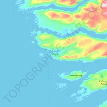
Name: Sisimiut topographic map, elevation, terrain.
Location: Sisimiut, Qeqqata, 3911, Greenland (66.77719 -53.82648 67.09719 -53.50648)
Average elevation: 108 m
Minimum elevation: -4 m
Maximum elevation: 1,100 m
The shoreline was still at a higher altitude than today, with the Sisimiut valley east of the Kangerluarsunnguaq Bay, partially under sea. Many artifacts and graves from the several centuries of permanent settlement remain scattered in the region. Rich in fauna, the coastal region from Sisimiut to Kangaamiut was particularly attractive for migrants, and due to a large number of historical artifacts it is currently listed as a candidate for the UNESCO World Heritage Site, with the application received in 2003.
Other topographic maps
Click on a map to view its topography, its elevation and its terrain.
Jakobshavn Glacier
Jakobshavn Glacier, Avannaata, Greenland
Average elevation: 452 m
Ittoqqortoormiit
Ittoqqortoormiit, Sermersooq, 3980, Greenland
Average elevation: 80 m
Kangerlussuaq
Kangerlussuaq, Sisimiut, Qeqqata, Greenland
Average elevation: 114 m
Traill-iup Immikkeertivi
Traill-iup Immikkeertivi, Sermersooq, Greenland
Average elevation: 0 m
Geographical Society Island
Geographical Society Island, Sermersooq, Greenland
Average elevation: 178 m