
Hunterdon County topographic map
Interactive map
Click on the map to display elevation.
Hunterdon County
Much of the county is hilly, with several hills rising to one thousand foot in elevation. The highest points are two areas in Lebanon Township, one on the Morris County line, both reaching approximately 1,060 feet (320 m) above sea level. The first is at Smith on the Morris County line and the second is north of the area called Little Brook. This area is known as the Highlands of New Jersey. The lowest elevation is where the Mercer County line reaches the Delaware River, approximately 50 feet (15 m) above sea level. The county is drained by the Musconetcong River in the north. The river flows in a southwest direction. The Lamington River drains the county in the east. The central portion of the county is drained by the South Branch of the Raritan River. The Delaware River drains the western side of the county.
About this map
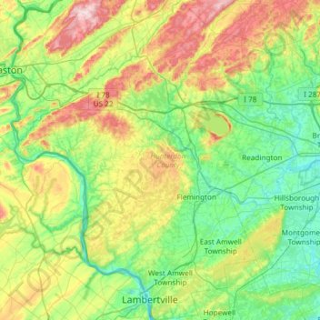
Name: Hunterdon County topographic map, elevation, terrain.
Location: Hunterdon County, New Jersey, United States (40.33943 -75.19554 40.78909 -74.70369)
Average elevation: 120 m
Minimum elevation: 10 m
Maximum elevation: 384 m
Other topographic maps
Click on a map to view its topography, its elevation and its terrain.
Elmer B Boyd Park
United States > New Jersey > Middlesex County > New Brunswick > Feaster Park
Average elevation: 22 m
Emleys Hill
United States > New Jersey > Monmouth County > Upper Freehold Township
Average elevation: 46 m
Hendrickson Corners
United States > New Jersey > Monmouth County > Middletown Township
Average elevation: 22 m
Hillside Terrace
United States > New Jersey > Mercer County > Robbinsville Township
Average elevation: 35 m
Marlboro
United States > New Jersey > Burlington County > Evesham Township > Marlton
Average elevation: 26 m
Burlington Heights
United States > New Jersey > Monmouth County > Freehold Township
Average elevation: 47 m
High Rock Mountain
United States > New Jersey > Warren County > White Township
Average elevation: 189 m
Marion
United States > New Jersey > Hudson County > Jersey City > Journal Square
Average elevation: 12 m
Schooleys Mountain
United States > New Jersey > Morris County > Washington Township
Average elevation: 293 m
Bearfort Mountain
United States > New Jersey > Passaic County > West Milford
At an elevation of 1,331 feet (406 m) the ridge is the site of a 68 feet (21 m) high fire lookout tower built by the New Jersey Forest Fire Service.
Average elevation: 354 m
Timbuctoo
United States > New Jersey > Burlington County > Westampton Township
Average elevation: 14 m
Fieldville
United States > New Jersey > Middlesex County > Piscataway Township
Average elevation: 17 m
Calais Crossroads
United States > New Jersey > Morris County > Randolph Township
Average elevation: 284 m
Sand Hills
United States > New Jersey > Middlesex County > Woodbridge Township > Fords
Average elevation: 24 m
Middlesex Downs
United States > New Jersey > Middlesex County > Monroe Township
Average elevation: 33 m
Mantua Grove
United States > New Jersey > Gloucester County > West Deptford Township
Average elevation: 11 m
Jobstown
United States > New Jersey > Burlington County > Springfield Township
Average elevation: 22 m
Parkville
United States > New Jersey > Gloucester County > West Deptford Township
Average elevation: 14 m
Creesville
United States > New Jersey > Gloucester County > Washington Township
Average elevation: 32 m
West Creek
United States > New Jersey > Cumberland County > Maurice River Township
Average elevation: 5 m
Cupsaw Lake
United States > New Jersey > Passaic County > Ringwood > Erskine Lakes
Average elevation: 157 m
Chimney Rock
United States > New Jersey > Somerset County > Bridgewater Township
Average elevation: 56 m
Washington Valley
United States > New Jersey > Morris County > Morris Township
Average elevation: 152 m
Andrews
United States > New Jersey > Camden County > Winslow Township > Sicklerville
Average elevation: 40 m