
Inner Mongolia topographic map
Interactive map
Click on the map to display elevation.
Inner Mongolia
Inner Mongolia largely consists of the northern side of the North China Craton, a tilted and sedimented Precambrian block. In the extreme southwest is the edge of the Tibetan Plateau where the autonomous region's highest peak, Main Peak in the Helan Mountains reaches 3,556 metres (11,670 ft), and is still being pushed up today in short bursts. Most of Inner Mongolia is a plateau averaging around 1,200 metres (3,940 ft) in altitude and covered by extensive loess and sand deposits. The northern part consists of the Mesozoic era Khingan Mountains, and is owing to the cooler climate more forested, chiefly with Manchurian elm, ash, birch, Mongolian oak and a number of pine and spruce species. Where discontinuous permafrost is present north of Hailar District, forests are almost exclusively coniferous. In the south, the natural vegetation is grassland in the east and very sparse in the arid west, and grazing is the dominant economic activity.
About this map
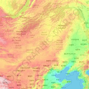
Name: Inner Mongolia topographic map, elevation, terrain.
Location: Inner Mongolia, China (37.40671 97.26948 53.33406 125.32729)
Average elevation: 890 m
Minimum elevation: -2 m
Maximum elevation: 4,789 m
Other topographic maps
Click on a map to view its topography, its elevation and its terrain.
Chongqing
The central urban area of Chongqing, or Chongqing proper, is a city of unique features. Built on mountains and partially surrounded by the Yangtze and Jialing rivers, it is known as a "mountain city" and a "city on rivers". The night scene of the city is very illuminated, with millions of lights and their…
Average elevation: 318 m
Huanglong
Huanglong County is located approximately 221 kilometres (137 mi) from Yan'an's urban core, and 226 kilometres (140 mi) from Xi'an's urban core. Located in the Loess Plateau, Huanglong County is hilly in elevation, ranging from 643.7 metres (2,112 ft) to 1,738 metres (5,702 ft) in height. A number of minor…
Average elevation: 1,348 m
Tanggula Mountains
China > Tibet > Amdo County > Yanshiping Town
The elevations of the main ridge average over 5,000 m (16,404 ft). The Yangtze River originates in this mountain range; Geladandong, 6,621 metres or 21,722 feet high, located in Tanggula Town, is the tallest peak in the range.
Average elevation: 5,912 m
Pubian
China > Guangdong Province > Fengkai County > Zhaoqing City > Jiangchuan
Average elevation: 43 m
Mount Makalu
China > Tibet > Tingri County
Makalu (Nepali: मकालु हिमाल, romanized: Makālu himāl; Chinese: 马卡鲁峰; pinyin: Mǎkǎlǔ Fēng) is the fifth-highest mountain on Earth, with a summit at an elevation of 8,485 metres (27,838 ft) AMSL. It is located in the Mahalangur Himalayas 19 km (12 mi) southeast of Mount Everest,…
Average elevation: 7,479 m
Yuanyang
China > Yunnan > Yuanyang County
It covers an area of 2,200 km2 (850 sq mi) and has a population of approximately 365,000 (2002), of which 88% belong to ethnic minorities and 95% is associated with agriculture. The majority of the inhabitants of the county are from the Hani ethnic group. The GDP of Yuanyang county in 2021 was 9,312 million…
Average elevation: 1,171 m
Medog
China > Tibet > Mêdog County > Medog Township
Due to the large elevation difference in the terrain, there are obvious vertical climate changes in the mountains. The annual sunshine hours in Medog County are 1500.7 hours, and the annual average temperature in the valley area is 18°C–22°C. The average temperature in July is 25°C–28°C, and the…
Average elevation: 2,371 m
Beijing
Beijing is situated at the northern tip of the roughly triangular North China Plain, which opens to the south and east of the city. Mountains to the north, northwest and west shield the city and northern China's agricultural heartland from the encroaching desert steppes. The northwestern part of the…
Average elevation: 47 m
Mischief Reef
China > Hainan Province > Sansha
Mischief Reef, also known as Panganiban Reef (Filipino: Bahura ng Panganiban; Vietnamese: Đá Vành Khăn; Mandarin Chinese: 美濟礁/美济礁; pinyin: Měijì Jiāo; lit. 'Meiji Reef'), is a low tide elevation (LTE) reef/atoll surrounding a large lagoon in the SE of Dangerous Ground in the east of the…
Average elevation: 0 m