
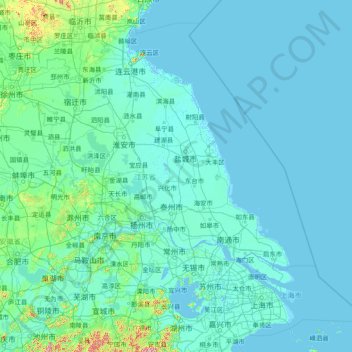
Jiangsu topographic map
Interactive map
Click on the map to display elevation.
About this map
Name: Jiangsu topographic map, elevation, terrain.
Location: Jiangsu, China (30.76033 116.35520 35.16667 122.38666)
Average elevation: 24 m
Minimum elevation: -3 m
Maximum elevation: 1,144 m
Jiangsu is flat, with plains covering 68 percent of its total area (water covers another 18 percent). Most of the province stands not more than 50 meters (160 ft) above sea level. Jiangsu also has a well-developed irrigation system, which earned it (especially the southern half) the moniker of traditional Chinese: 水鄕; simplified Chinese: 水乡 (shuǐxiāng "land of water"). The southern city of Suzhou has so many canals that it has been dubbed "Venice of the East" or the "Venice of the Orient." The Grand Canal of China cuts through Jiangsu from north to south, crossing all the east–west river systems. Jiangsu also borders the Yellow Sea. The Yangtze River, the longest river of China, cuts through the province in the south and reaches the East China Sea, which divides the region into two parts: more urban, prosperous south and more poorer, rural north, and these two parts has a tense division. Mount Huaguo, near the city of Lianyungang, is the highest point in Jiangsu, at an altitude of 625 meters (2,051 ft) above sea level. Large lakes in Jiangsu include Lake Tai (the largest), Lake Hongze, Lake Gaoyou, Lake Luoma, and Lake Yangcheng.
Other topographic maps
Click on a map to view its topography, its elevation and its terrain.
Huai'an County
China > Hebei > Zhangjiakou
Huai'an County, Zhangjiakou, Hebei, China
Average elevation: 1,103 m
Xuanhua District
Xuanhua District, Zhangjiakou, Hebei, 075200, China
Average elevation: 945 m
Boluo
Boluo, Huizhou, Guangdong Province, 516100, China
Average elevation: 107 m
Tianzhen County
Tianzhen County, Datong, Shanxi, 038200, China
Average elevation: 1,239 m
Jiajin
China > Sichuan > Xiaojin County
Jiajin, Xiaojin County, Ngawa Tibetan and Qiang Autonomous Prefecture, Sichuan, China
Average elevation: 3,427 m
Lugu Lake
China > Sichuan > Yanyuan County > Mukua
Lugu Lake, Mukua, Yanyuan County, Liangshan, Sichuan, 615700, China
Average elevation: 2,750 m
Zhaoqing City
Zhaoqing City, Guangdong Province, China
Average elevation: 200 m
Ulaan
China > Inner Mongolia > Otog Banner
Ulaan, Otog Banner, Ordos City, Inner Mongolia, 016100, China
Average elevation: 1,384 m
塔合曼乡 تاغارما يېزىسى
China > Xinjiang > Taxkorgan Tajik Autonomous County
塔合曼乡 تاغارما يېزىسى, Taxkorgan Tajik Autonomous County, Kachgar, Xinjiang, China
Average elevation: 4,282 m
Wuzhizhou Island
China > Hainan Province > Haitang District
Wuzhizhou Island, Haitang District, Sanya City, Hainan Province, China
Average elevation: 3 m
Qiongshan District
China > Hainan Province > Haikou City
Qiongshan District, Haikou City, Hainan Province, 571138, China
Average elevation: 47 m
Xinzhuang
China > Tianjin > Jinnan District
Xinzhuang, Jinnan District, Tianjin, China
Average elevation: 3 m
Songshan District
Songshan District, Chifeng City, Inner Mongolia, 024000, China
Average elevation: 834 m
Huaiji County
Huaiji County, Zhaoqing City, Guangdong Province, China
Average elevation: 319 m
Delgon
China > Tibet > Mêdog County > Drepung
Delgon, Drepung, Mêdog County, Nyingchi Prefecture, Tibet, China
Average elevation: 1,699 m
Qu'nyido
China > Tibet > Jomda County
Qu'nyido, Jomda County, Chamdo City, Tibet, China
Average elevation: 4,324 m
Guangyang District
Guangyang District, Langfang, Hebei, 102802, China
Average elevation: 16 m
Zanda Earth Forest
China > Tibet > Tsamda County > Thoding Township
Zanda Earth Forest, Y708, Thoding Township, Tsamda County, Ngari Prefecture, Tibet, China
Average elevation: 4,340 m
Jinniu District
Jinniu District, Chengdu, High-Tech Zone (West), Sichuan, China
Average elevation: 512 m
Lhodrak
China > Tibet > Lhodrak County > Lhozhag
Lhodrak, Lhozhag, Lhodrak County, Lhoka, Tibet, China
Average elevation: 4,789 m
Wumao
China > Yunnan > Yuanmou County
Wumao, Yuanmou County, Chuxiong, Yunnan, China
Average elevation: 1,147 m
Huangcaoling
China > Guangdong Province > Gaozhou City > Maoming City
Huangcaoling, Gaozhou City, Maoming City, Guangdong Province, China
Average elevation: 485 m
Toudi
China > Inner Mongolia > Hexigten Banner > Wanheyong
Toudi, Wanheyong, Hexigten Banner, Chifeng City, Inner Mongolia, China
Average elevation: 1,097 m
Lishui District
Lishui District, Nanjing City, Jiangsu, 211200, China
Average elevation: 28 m
Maguan
China > Yunnan > Maguan County
Maguan, 白马镇, Maguan County, Wenshan, Yunnan, 663700, China
Average elevation: 1,377 m
Taiku Lake
China > Tibet > Shuanghu County > Garco
Taiku Lake, Garco, Shuanghu County, Nagqu City, Tibet, China
Average elevation: 4,941 m
Xingyun Jiayuan
China > Beijing > Yanqing District
Xingyun Jiayuan, Yanqing District, Beijing, 102100, China
Average elevation: 493 m