
Cox's Bazar topographic map
Interactive map
Click on the map to display elevation.
Cox's Bazar
Cox's Bazar lies on a coastal plain in the southeastern corner of Bangladesh. From above, the plain appears to bulge out into the Bay of Bengal. Along the shore is an extensive area of beach and dunes. Most of the city is built on a floodplain that is lower in elevation than the dunes, making it more susceptible to flooding due to cyclones and storm surges. The Cox's Bazar coastal plain was formed after the sea reached its present level around 6,500 years ago, with the area of the current floodplain originally forming a sediment sink that has since been gradually filled in by the Bakkhali river as well as smaller streams coming down from the hills.
About this map
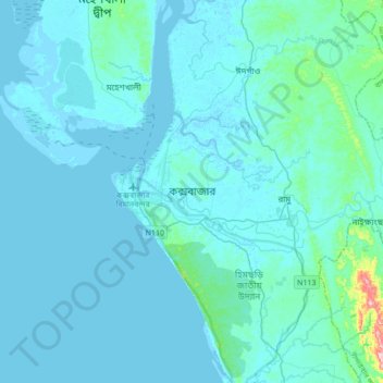
Name: Cox's Bazar topographic map, elevation, terrain.
Average elevation: 8 m
Minimum elevation: -3 m
Maximum elevation: 89 m
Other topographic maps
Click on a map to view its topography, its elevation and its terrain.
Chattogram District
Bangladesh > Chattogram Division
The district's topography is primarily defined by a series of low hill ranges running roughly parallel to the coast and with each other. Between these hill ranges are broad alluvial valleys with sandstone bedrock, and they are also divided by several major rivers, namely the Karnaphuli and Sangu. The most…
Average elevation: 28 m
Camp 21
Bangladesh > Chattogram Division > Rohingya Refugee Camp in Bangladesh
Average elevation: 15 m
Sitakunda Upazila
Bangladesh > Chattogram Division
Sitakunda Upazila occupies an area of 483.97 square kilometres (186.86 sq mi), which includes 61.61 square kilometres (23.79 sq mi) of forest. It is bordered by Mirsharai to the north, Pahartali to the south, Fatickchhari, Hathazari and Panchlaish to the east, and the Sandwip Channel in the Bay of Bengal to…
Average elevation: 15 m
Waggachara Tea Estate
Bangladesh > Chattogram Division > Rangamati Hill District
Average elevation: 64 m
Kutupalong RC
Bangladesh > Chattogram Division > Rohingya Refugee Camp in Bangladesh
Average elevation: 14 m