
Scott County topographic map
Interactive map
Click on the map to display elevation.
About this map
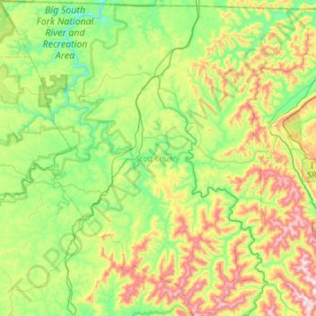
Name: Scott County topographic map, elevation, terrain.
Location: Scott County, East Tennessee, Tennessee, United States (36.16299 -84.78568 36.60341 -84.24923)
Average elevation: 493 m
Minimum elevation: 252 m
Maximum elevation: 1,039 m
Other topographic maps
Click on a map to view its topography, its elevation and its terrain.
Pinson Mounds State Archaeological Area
United States > Tennessee > Madison County
Average elevation: 120 m
Millersville City Park
United States > Tennessee > Robertson County > Millersville
Average elevation: 260 m
Brainerd
United States > Tennessee > Hamilton County > Chattanooga > Ridgeside
Average elevation: 234 m
Douglas Dam
United States > Tennessee > Sevier County > Sevierville
The Douglas Project required the construction of ten smaller, earthen saddle dams to fill in gaps along the adjacent ridgeline and permit a higher water elevation than would otherwise be possible. Most of these saddle dams are located in the hills southeast of the main dam. One protects downtown Dandridge,…
Average elevation: 312 m
Edwin Warner Park
United States > Tennessee > Davidson County > Nashville > Devonshire Manor
Average elevation: 198 m
Evergreen Estates
United States > Tennessee > Montgomery County > Clarksville
Average elevation: 147 m
Loafer's Corner
United States > Tennessee > Rutherford County > Smyrna > Smyrna
Average elevation: 183 m
Barfield Crescent Park
United States > Tennessee > Rutherford County > Murfreesboro
Average elevation: 201 m
Northcreek Commons
United States > Tennessee > Davidson County > Goodlettsville
Average elevation: 155 m
Montcastle Hills
United States > Tennessee > Washington County > Johnson City
Average elevation: 506 m
Mountain Ridge
United States > Tennessee > Hamilton County > Chattanooga > Red Bank
Average elevation: 249 m