Geolocate

Gear up for your next adventure:

As an Amazon Associate, this site earns from qualifying purchases at no extra cost to you.

👉 Easily get elevation data in JSON, GeoTIFF and KML formats using Elevation API
Thank you for supporting this site ❤️
Make a donation

Hinton Parva topographic map

Click on the map to display elevation.

Gear up for your next adventure:

As an Amazon Associate, this site earns from qualifying purchases at no extra cost to you.

Gear up for your next adventure:

As an Amazon Associate, this site earns from qualifying purchases at no extra cost to you.

👉 Easily get elevation data in JSON, GeoTIFF and KML formats using Elevation API
Thank you for supporting this site ❤️
Make a donation

About this map

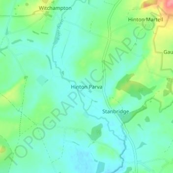
Name: Hinton Parva topographic map, elevation, terrain.

Location: Hinton Parva, Dorset, England, BH21 4JG, United Kingdom (50.81974 -2.02537 50.85974 -1.98537)

Average elevation: 39 m

Minimum elevation: 20 m

Maximum elevation: 98 m

Dorset trails, hiking, mountain biking, running and outdoor activities

Gear up for your next adventure:

As an Amazon Associate, this site earns from qualifying purchases at no extra cost to you.

👉 Easily get elevation data in JSON, GeoTIFF and KML formats using Elevation API
Thank you for supporting this site ❤️
Make a donation

Other topographic maps

Click on a map to view its topography, its elevation and its terrain.

Tincleton

United Kingdom > England > Dorset

Average elevation: 53 m

Fontmell Magna

United Kingdom > England > Dorset

Average elevation: 123 m

River Frome

United Kingdom > England > Dorset

Average elevation: 84 m

Witchampton

United Kingdom > England > Dorset

Average elevation: 46 m

Thornford

United Kingdom > England > Dorset

Average elevation: 65 m

Gear up for your next adventure:

As an Amazon Associate, this site earns from qualifying purchases at no extra cost to you.

Thank you for supporting this site ❤️
Make a donation

Pamphill

United Kingdom > England > Dorset > Pamphill

Average elevation: 35 m

Gillingham

United Kingdom > England > Dorset

Average elevation: 93 m

Cranborne

United Kingdom > England > Dorset

Average elevation: 90 m

Buckhorn Weston

United Kingdom > England > Dorset

Average elevation: 89 m

Stinsford

United Kingdom > England > Dorset

Average elevation: 83 m

Gear up for your next adventure:

As an Amazon Associate, this site earns from qualifying purchases at no extra cost to you.

Thank you for supporting this site ❤️
Make a donation

Wimborne Minster

United Kingdom > England > Dorset

Average elevation: 32 m

Isle of Portland

United Kingdom > England > Dorset > Wyke Regis

In Museums Without Walls, Jonathan Meades declares that "Portland is a bulky chunk of geological, social, topographical and demographic weirdness. It is the obverse of a beauty spot. 'Beauty' in this construction implies the picturesque. Portland is gloriously bereft of this quality. It is awesome. There is…

Average elevation: 11 m

Verwood

United Kingdom > England > Dorset

Average elevation: 40 m

Milborne St. Andrew

United Kingdom > England > Dorset

Average elevation: 93 m

Gear up for your next adventure:

As an Amazon Associate, this site earns from qualifying purchases at no extra cost to you.

Thank you for supporting this site ❤️
Make a donation

Winterbourne Abbas

United Kingdom > England > Dorset

Average elevation: 148 m

Shaftesbury

United Kingdom > England > Dorset

The English name was recorded in the Domesday Book of 1086 as Sceptesberie, and the use of "Shaston" (/ˈʃæstən/) was recorded in 1831 in Samuel Lewis's A Topographical Dictionary of England and in 1840 in The Parliamentary Gazetteer of England and Wales.

Average elevation: 167 m

Clifton Maybank

United Kingdom > England > Dorset

Average elevation: 46 m

Wool

United Kingdom > England > Dorset > Bovington

Average elevation: 37 m

Gear up for your next adventure:

As an Amazon Associate, this site earns from qualifying purchases at no extra cost to you.

Thank you for supporting this site ❤️
Make a donation

Charminster

United Kingdom > England > Dorset

Average elevation: 108 m

Jurassic Coast

United Kingdom > England > Dorset > East Devon

Average elevation: 49 m

Buckland Newton

United Kingdom > England > Dorset

Average elevation: 142 m

Sturminster Newton

United Kingdom > England > Dorset

Average elevation: 66 m

Marnhull

United Kingdom > England > Dorset

Average elevation: 65 m

Gear up for your next adventure:

As an Amazon Associate, this site earns from qualifying purchases at no extra cost to you.

Thank you for supporting this site ❤️
Make a donation

Forde Abbey

United Kingdom > England > Dorset > Chard > Forde Abbey

Average elevation: 100 m

Church Knowle

United Kingdom > England > Dorset

Average elevation: 67 m

Sturminster Newton

United Kingdom > England > Dorset

Average elevation: 66 m

Moreton

United Kingdom > England > Dorset

Average elevation: 35 m

Corfe Mullen

United Kingdom > England > Dorset

Average elevation: 45 m

Gear up for your next adventure:

As an Amazon Associate, this site earns from qualifying purchases at no extra cost to you.

Thank you for supporting this site ❤️
Make a donation

Lyme Regis

United Kingdom > England > Dorset

Lyme Regis is a coastal town in West Dorset, 25 miles (40 km) west of Dorchester and 25 miles (40 km) east of Exeter. It lies in Lyme Bay, on the English Channel coast at the Dorset–Devon border. At the 2011 census, it had a population of 3,671. The town has grown around the mouth of the River Lim (or Lym)…

Average elevation: 83 m

Portland

United Kingdom > England > Dorset > Castletown

Average elevation: 8 m

Holnest

United Kingdom > England > Dorset

Average elevation: 87 m

Evershot

United Kingdom > England > Dorset > Evershot

Average elevation: 156 m

Gear up for your next adventure:

As an Amazon Associate, this site earns from qualifying purchases at no extra cost to you.

Thank you for supporting this site ❤️
Make a donation

Portland

United Kingdom > England > Dorset > Castletown

Average elevation: 8 m

South Perrott

United Kingdom > England > Dorset

Average elevation: 108 m

Dorchester

United Kingdom > England > Dorset

Average elevation: 72 m

River Axe

United Kingdom > England > Dorset

Average elevation: 92 m

Gussage All Saints

United Kingdom > England > Dorset

Average elevation: 74 m

Gear up for your next adventure:

As an Amazon Associate, this site earns from qualifying purchases at no extra cost to you.

Thank you for supporting this site ❤️
Make a donation

Weymouth

United Kingdom > England > Dorset

Average elevation: 36 m

Wareham Town

United Kingdom > England > Dorset

Average elevation: 10 m

Hazelbury Bryan

United Kingdom > England > Dorset

Average elevation: 91 m

Gear up for your next adventure:

As an Amazon Associate, this site earns from qualifying purchases at no extra cost to you.

Thank you for supporting this site ❤️
Make a donation

West Moors

United Kingdom > England > Dorset

Average elevation: 19 m

Dorchester

United Kingdom > England > Dorset

Average elevation: 72 m

East Lulworth

United Kingdom > England > Dorset

Average elevation: 64 m

Frome Vauchurch

United Kingdom > England > Dorset

Average elevation: 144 m

Gear up for your next adventure:

As an Amazon Associate, this site earns from qualifying purchases at no extra cost to you.

Thank you for supporting this site ❤️
Make a donation

Winterborne Kingston

United Kingdom > England > Dorset

Average elevation: 77 m

Beaminster

United Kingdom > England > Dorset

Average elevation: 136 m

Nether Compton

United Kingdom > England > Dorset

Average elevation: 85 m

West Moors

United Kingdom > England > Dorset

Average elevation: 19 m

Dorchester

United Kingdom > England > Dorset

Average elevation: 72 m

Gear up for your next adventure:

As an Amazon Associate, this site earns from qualifying purchases at no extra cost to you.

Thank you for supporting this site ❤️
Make a donation

Thorncombe

United Kingdom > England > Dorset

Average elevation: 110 m

Buckhorn Weston

United Kingdom > England > Dorset

Average elevation: 89 m

Dorchester

United Kingdom > England > Dorset

Average elevation: 72 m

Wimborne St. Giles

United Kingdom > England > Dorset

Average elevation: 82 m

Compton Abbas

United Kingdom > England > Dorset

Average elevation: 132 m

Gear up for your next adventure:

As an Amazon Associate, this site earns from qualifying purchases at no extra cost to you.

Thank you for supporting this site ❤️
Make a donation

Charlton Marshall

United Kingdom > England > Dorset

Average elevation: 59 m

Askerswell

United Kingdom > England > Dorset

Average elevation: 137 m

West Lulworth

United Kingdom > England > Dorset

Average elevation: 85 m

Shaftesbury

United Kingdom > England > Dorset

The English name was recorded in the Domesday Book of 1086 as Sceptesberie, and the use of "Shaston" (/ˈʃæstən/) was recorded in 1831 in Samuel Lewis's A Topographical Dictionary of England and in 1840 in The parliamentary gazetteer of England and Wales.

Average elevation: 167 m

Piddlehinton

United Kingdom > England > Dorset

Average elevation: 118 m

Gear up for your next adventure:

As an Amazon Associate, this site earns from qualifying purchases at no extra cost to you.

Thank you for supporting this site ❤️
Make a donation

Marnhull

United Kingdom > England > Dorset

Average elevation: 65 m

Broadmayne

United Kingdom > England > Dorset

Average elevation: 84 m

River Piddle

United Kingdom > England > Dorset > East Stoke

Average elevation: 79 m

Okeford Fitzpaine

United Kingdom > England > Dorset

Average elevation: 95 m

Gear up for your next adventure:

As an Amazon Associate, this site earns from qualifying purchases at no extra cost to you.

Thank you for supporting this site ❤️
Make a donation

Tarrant Rushton

United Kingdom > England > Dorset

Average elevation: 69 m

North Dorset

United Kingdom > England > Dorset

Average elevation: 104 m

East Stour

United Kingdom > England > Dorset

Average elevation: 91 m

Dancing Ledge

United Kingdom > England > Dorset

Average elevation: 55 m

Gear up for your next adventure:

As an Amazon Associate, this site earns from qualifying purchases at no extra cost to you.

Thank you for supporting this site ❤️
Make a donation

Todber

United Kingdom > England > Dorset

Average elevation: 66 m

Child Okeford

United Kingdom > England > Dorset

Average elevation: 67 m

Frome St. Quintin

United Kingdom > England > Dorset

Average elevation: 184 m

Trent

United Kingdom > England > Dorset

Average elevation: 57 m

Winfrith Newburgh

United Kingdom > England > Dorset

Average elevation: 68 m

Gear up for your next adventure:

As an Amazon Associate, this site earns from qualifying purchases at no extra cost to you.

Thank you for supporting this site ❤️
Make a donation

Stockwood

United Kingdom > England > Dorset

Average elevation: 86 m

Swanage Beach

United Kingdom > England > Dorset > Swanage

Average elevation: 25 m

Winterborne Houghton

United Kingdom > England > Dorset

Average elevation: 179 m

Warmwell

United Kingdom > England > Dorset

Average elevation: 62 m

Colehill

United Kingdom > England > Dorset > Furzehill

Average elevation: 30 m

Gear up for your next adventure:

As an Amazon Associate, this site earns from qualifying purchases at no extra cost to you.

Thank you for supporting this site ❤️
Make a donation

Bridport

United Kingdom > England > Dorset

Bridport is in the county of Dorset in South West England. Measured directly, it is about 14 miles (23 km) west of the county town Dorchester, 15.5 miles (25 km) SSW of Yeovil in Somerset, 33 miles (53 km) east of Exeter in Devon and 1.5 miles (2.4 km) inland from the English Channel at West Bay. The town…

Average elevation: 39 m

Blandford Forum

United Kingdom > England > Dorset

Average elevation: 60 m

West Parley

United Kingdom > England > Dorset

Average elevation: 17 m

Woolland

United Kingdom > England > Dorset

Average elevation: 159 m

Edmondsham

United Kingdom > England > Dorset > Edmondsham

Average elevation: 62 m

Gear up for your next adventure:

As an Amazon Associate, this site earns from qualifying purchases at no extra cost to you.

Thank you for supporting this site ❤️
Make a donation

Moreton

United Kingdom > England > Dorset

Average elevation: 34 m

Mappowder

United Kingdom > England > Dorset

Average elevation: 103 m

Burton Mere

United Kingdom > England > Dorset

Average elevation: 28 m

Toller Fratrum

United Kingdom > England > Dorset

Average elevation: 137 m

Dewlish

United Kingdom > England > Dorset

Average elevation: 104 m

Gear up for your next adventure:

As an Amazon Associate, this site earns from qualifying purchases at no extra cost to you.

Thank you for supporting this site ❤️
Make a donation

Osmington

United Kingdom > England > Dorset

Average elevation: 57 m

North Poorton

United Kingdom > England > Dorset > North Poorton

Average elevation: 119 m

Puncknowle

United Kingdom > England > Dorset

Average elevation: 79 m

Iwerne Minster

United Kingdom > England > Dorset

Average elevation: 109 m

Winterborne Stickland

United Kingdom > England > Dorset

Average elevation: 136 m

Gear up for your next adventure:

As an Amazon Associate, this site earns from qualifying purchases at no extra cost to you.

Thank you for supporting this site ❤️
Make a donation