
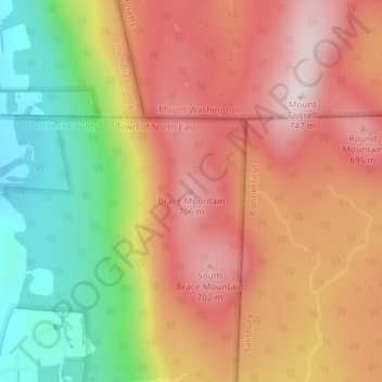
Brace Mountain topographic map
Interactive map
Click on the map to display elevation.
About this map
Name: Brace Mountain topographic map, elevation, terrain.
Average elevation: 520 m
Minimum elevation: 234 m
Maximum elevation: 740 m
Other topographic maps
Click on a map to view its topography, its elevation and its terrain.
New York
New York City's topography is a fascinating blend of varied elevations and unique landscapes, reflecting its diverse geography across five boroughs. Situated at the confluence of the Hudson and East Rivers, the city primarily features low-lying terrain, with the average elevation hovering around sea level.…
Average elevation: 19 m
Long Island
The land to the south of this moraine to the South Shore is the outwash plain of the last glacier. One part of the outwash plain was known as the Hempstead Plains, and this land contained one of the few natural prairies to exist east of the Appalachian Mountains. The glaciers melted and receded to the north,…
Average elevation: 42 m
City of Ithaca
United States > New York > Tompkins County
Ithaca is characterized by a diverse topography that significantly influences its natural environment and urban layout. Nestled at the southern tip of Cayuga Lake, the city features a floodplain area with an average elevation around 636 feet (194 meters) above sea level, though it rises to approximately 1,214…
Average elevation: 195 m
Erie County
The northern border of the county is Tonawanda Creek. Part of the southern border is Cattaraugus Creek. Other major streams include Buffalo Creek (Buffalo River), Cayuga Creek, Cazenovia Creek, Scajaquada Creek, Eighteen Mile Creek and Ellicott Creek. The county's northern half, including Buffalo and its…
Average elevation: 286 m
Manhattan
United States > New York > New York County > New York
Manhattan, a densely populated urban island, has a diverse topography characterized by its generally flat terrain interspersed with elevated areas. The average elevation is about 50 feet (15 meters) above sea level, with its highest point reaching approximately 265 feet (81 meters) at Bennett Park in…
Average elevation: 16 m
City of Albany
United States > New York > Albany County
The highest natural point in Albany is a USGS benchmark near the Loudonville Reservoir off Birch Hill Road, at 378 feet (115 m) above sea level. The lowest point is sea level at the Hudson River (the average water elevation is 2 feet (0.61 m)), which is still technically an estuary at Albany and is affected by…
Average elevation: 68 m
City of Binghamton
United States > New York > Broome County
Binghamton, like all of the Southern Tier of New York, lies on the Allegheny Plateau; hence its hilly terrain. As such, elevations can vary in the city--Downtown, for example, is at an elevation of around 860 feet, while residential homes in the hills can go up to over 1,800 feet, such as on Ingram Hill. The…
Average elevation: 321 m
Staten Island
United States > New York > New York
Although Staten Island is a borough of New York City, the island is topographically and geologically a part of New Jersey. Staten Island is separated from Long Island by the Narrows and from mainland New Jersey by the Arthur Kill and the Kill Van Kull. Staten Island is positioned at the center of New York…
Average elevation: 9 m
Bronx County
United States > New York > New York
The Bronx's highest elevation at 280 feet (85 m) is in the northwest corner, west of Van Cortlandt Park and in the Chapel Farm area near the Riverdale Country School. The opposite (southeastern) side of the Bronx has four large low peninsulas or "necks" of low-lying land that jut into the waters of the East…
Average elevation: 21 m
Buffalo
United States > New York > Erie County
Buffalo is characterized by its relatively flat terrain, predominantly lying on the Erie/Ontario Lake Plain, which forms part of the Eastern Great Lakes Lowlands. The city's elevation averages around 607 feet above sea level, with minor variations, particularly in neighborhoods like University Heights, which…
Average elevation: 185 m
Queens County
United States > New York > New York
Many of the village street grids of Queens had only worded names, some were numbered according to local numbering schemes, and some had a mix of words and numbers. In the early 1920s, a "Philadelphia Plan" was instituted to overlay one numbered system upon the whole borough. The Topographical Bureau, Borough…
Average elevation: 11 m
Central Park
United States > New York > New York County > New York
In June 1856, Fernando Wood appointed a "consulting board" of seven people, headed by author Washington Irving, to inspire public confidence in the proposed development. Wood hired military engineer Egbert Ludovicus Viele as the park's chief engineer, tasking him with a topographical survey of the site. The…
Average elevation: 26 m
Suffolk County
The highest elevation in the county, and on Long Island as a whole, is Jayne's Hill in West Hills, at 401 feet (122 m) above sea level.
Average elevation: 34 m
Hudson River
The Hudson then flows south, taking in Beaver Brook and the outlet of Lake Harris. After its confluence with the Indian River, the Hudson forms the boundary between Essex and Hamilton counties. In the hamlet of North River, the Hudson flows entirely in Warren County and takes in the Schroon River. Further…
Average elevation: 297 m
Saratoga County
Saratoga County is situated in the eastern portion of New York State, north of the state capital city of Albany, northwest of Troy, and east of Utica. According to the U.S. Census Bureau, the county has a total area of 844 square miles (2,190 km2), of which 810 square miles (2,100 km2) are land and 34 square…
Average elevation: 218 m
Long Island
The land to the south of this moraine to the South Shore is the outwash plain of the last glacier. One part of the outwash plain was known as the Hempstead Plains, and this land contained one of the few natural prairies to exist east of the Appalachian Mountains. The glaciers melted and receded to the north,…
Average elevation: 42 m
The Bronx
United States > New York > Bronx County > New York
The Bronx's highest elevation at 280 feet (85 m) is in the northwest corner, west of Van Cortlandt Park and in the Chapel Farm area near the Riverdale Country School. The opposite (southeastern) side of the Bronx has four large low peninsulas or "necks" of low-lying land that jut into the waters of the East…
Average elevation: 23 m
City of Albany
United States > New York > Albany County
The highest natural point in Albany is a USGS benchmark near the Loudonville Reservoir off Birch Hill Road, at 378 feet (115 m) above sea level. The lowest point is sea level at the Hudson River (the average water elevation is 2 feet (0.61 m)), which is still technically an estuary at Albany and is affected by…
Average elevation: 68 m
Buffalo
United States > New York > Erie County
The Buffalo metropolitan area is on the Erie/Ontario Lake Plain of the Eastern Great Lakes Lowlands, a narrow plain extending east to Utica, New York. The city is generally flat, except for elevation changes in the University Heights and Fruit Belt neighborhoods. The Southtowns are hillier, leading to the…
Average elevation: 185 m
Chautauqua County
The county is generally composed of rolling hills and valleys, with elevations ranging anywhere between 1100 and 2100 feet, although the land within a few miles of Lake Erie is generally flat and at an elevation of 1000 feet or lower. The lowest point in the county is Lake Erie, at 571 feet (174 meters), and…
Average elevation: 328 m
Erie County
The northern border of the county is Tonawanda Creek. Part of the southern border is Cattaraugus Creek. Other major streams include Buffalo Creek (Buffalo River), Cayuga Creek, Cazenovia Creek, Scajaquada Creek, Eighteen Mile Creek and Ellicott Creek. The county's northern half, including Buffalo and its…
Average elevation: 286 m
Queens
United States > New York > Queens County > New York
Many of the village street grids of Queens had only worded names, some were numbered according to local numbering schemes, and some had a mix of words and numbers. In the early 1920s, a "Philadelphia Plan" was instituted to overlay one numbered system upon the whole borough. The Topographical Bureau, Borough…
Average elevation: 11 m
Staten Island
United States > New York > New York
Although Staten Island is a borough of New York City, the island is topographically and geologically a part of New Jersey. Staten Island is separated from Long Island by the Narrows and from mainland New Jersey by the Arthur Kill and the Kill Van Kull. Staten Island is positioned at the center of New York…
Average elevation: 9 m
Adirondack Park
Adirondack Park, covering over six million acres, features a diverse topography characterized by rugged mountains, extensive forests, and numerous waterways. The park is dominated by the Adirondack Mountains, which contain 46 peaks exceeding 4,000 feet, with Mount Marcy standing at 5,343 feet as the highest…
Average elevation: 371 m
Hudson River
The source of the Hudson River is Lake Tear of the Clouds in the Adirondack Park at an elevation of 4,322 feet (1,317 m). However, the river is not cartographically called the Hudson River until miles downstream. The river is named Feldspar Brook until its confluence with the Opalescent River, and then is…
Average elevation: 297 m
Monroe County
Monroe County features a diverse topography characterized by rolling hills, flat plains, and numerous water bodies, including Lake Ontario to the north. The terrain rises gently from the shores of the lake, with elevations reaching approximately 800 feet (244 meters) in the southern regions, particularly near…
Average elevation: 122 m
Onondaga County
According to the U.S. Census Bureau, the county has an area of 806 square miles (2,090 km2), of which 778 square miles (2,020 km2) is land and 27 square miles (70 km2) (3.4%) is water. The geographic dimensions of the county are illustrated as approximately 35 miles (56 km) in length and 30 miles (48 km) in…
Average elevation: 233 m
Town of Highlands
United States > New York > Orange County
Highlands is located at 41°21′36″N 074°00′30″W / 41.36000°N 74.00833°W / 41.36000; -74.00833 (41.3601108, -74.0084276) and its elevation is 1,017 feet (310 m). According to the 2020 U.S. census, the town has a total area of 33.46 square miles (86.66 km2), of which 30.40 square miles (78.74…
Average elevation: 192 m
City of Binghamton
United States > New York > Broome County
Binghamton, like all of the Southern Tier of New York, lies on the Allegheny Plateau; hence its hilly terrain. As such, elevations can vary in the city--Downtown, for example, is at an elevation of around 860 feet (262 meters), while residential homes in the hills can go up to over 1,800 feet (548 meters),…
Average elevation: 321 m
Manhattan
United States > New York > New York County > New York
Marble Hill is one example of how Manhattan's land has been considerably altered by human intervention. The borough has seen substantial land reclamation along its waterfronts since Dutch colonial times, and much of the natural variation in its topography has been evened out.
Average elevation: 16 m
Suffolk County
The highest elevation in the county, and on Long Island as a whole, is Jayne's Hill in West Hills, at 401 feet (122 m) above sea level. This low lying-geography means that much of the county is vulnerable to sea level rise.
Average elevation: 34 m
Town of Highlands
United States > New York > Orange County
Highlands is located at 41°21′36″N 074°00′30″W / 41.36000°N 74.00833°W / 41.36000; -74.00833 (41.3601108, -74.0084276) and its elevation is 1,017 feet (310 m). According to the 2020 U.S. census, the town has a total area of 33.46 square miles (86.66 km2), of which 30.40 square miles (78.74…
Average elevation: 192 m
Village of Lake Placid
United States > New York > Essex County
Lake Placid is well known among winter-sports enthusiasts for its skiing, both Alpine and Nordic. Whiteface Mountain (4,867 ft or 1,483 m), in nearby Wilmington about 13 miles (21 km) from Lake Placid, offers skiing, hiking, gondola rides, and mountain biking, and is the only one of the High Peaks that can be…
Average elevation: 558 m
Broome County
The county's western portion is hilly, with wide valleys that accommodate Binghamton and its suburbs. In the northern portion, Interstate 81 traverses a wide glacial valley. The eastern part of the county is much more rugged, as the land rises to the Catskill Mountains. The terrain generally slopes to the…
Average elevation: 413 m
New York
New York City's topography is a fascinating blend of varied elevations and unique landscapes, reflecting its diverse geography across five boroughs. Situated at the confluence of the Hudson and East Rivers, the city primarily features low-lying terrain, with the average elevation hovering around sea level.…
Average elevation: 19 m
Village of Lake Placid
United States > New York > Essex County
Lake Placid is well known among winter-sports enthusiasts for its skiing, both Alpine and Nordic. Whiteface Mountain (4,867 ft or 1,483 m), in nearby Wilmington about 13 miles (21 km) from Lake Placid, offers skiing, hiking, gondola rides, and mountain biking, and is the only one of the High Peaks that can be…
Average elevation: 558 m
Richmond County
United States > New York > New York
The highest point on the island, the summit of Todt Hill, elevation 401 ft (122 m), is also the highest point in the five boroughs, as well as the highest point on the Atlantic coastal plain south of Great Blue Hill in Massachusetts and the highest point on the coast proper south of Maine's Camden Hills.…
Average elevation: 9 m
Finger Lakes National Forest
United States > New York > Schuyler County > Town of Hector
Average elevation: 356 m
Huntington Station
United States > New York > Suffolk County > Huntington Station
Average elevation: 61 m
Westchester County
At 987 feet (301 m), the highest elevation in the county is a U.S. Coast and Geodetic Survey benchmark known as "Bailey" in Mountain Lakes Park near the Connecticut state line. The lowest elevation is sea level, along both the Hudson and Long Island Sound.
Average elevation: 95 m
Village of Valley Stream
United States > New York > Nassau County
At this time, the community did not have a post office, so residents had to pick up their mail in the village of Hempstead. After Pagan petitioned authorities for a post office, he was appointed postmaster and it was based in his farmhouse, now known as the Pagan-Fletcher House. He was advised that the…
Average elevation: 7 m
New York
The city's land has been altered substantially by human intervention, with considerable land reclamation along the waterfronts since Dutch colonial times; reclamation is most prominent in Lower Manhattan, with developments such as Battery Park City in the 1970s and 1980s. Some of the natural relief in…
Average elevation: 19 m
Niagara Escarpment
United States > New York > Niagara County > City of Lockport
Average elevation: 149 m
Village of Lake Placid
United States > New York > Essex County
Lake Placid is well known among winter-sports enthusiasts for its skiing, both Alpine and Nordic. Whiteface Mountain (4,867 ft or 1,483 m), in nearby Wilmington about 13 miles (21 km) from Lake Placid, offers skiing, hiking, gondola rides, and mountain biking, and is the only one of the High Peaks that can be…
Average elevation: 558 m