
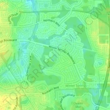
Sam Smith Memorial Park topographic map
Interactive map
Click on the map to display elevation.
About this map
Name: Sam Smith Memorial Park topographic map, elevation, terrain.
Average elevation: 14 m
Minimum elevation: 4 m
Maximum elevation: 24 m
Other topographic maps
Click on a map to view its topography, its elevation and its terrain.
Pinellas County
Elevation in the county ranges from mean sea level to its highest natural point of 110 feet (34 m) near the intersection of SR 580 and Countryside Blvd. in Clearwater. Due to its small size and high population, by the early 21st century Pinellas County has been mostly built out, with very little developable…
Average elevation: 4 m
Tampa
United States > Florida > Hillsborough County
Tampa is characterized by a predominantly flat topography, with an average elevation around 16 to 49 feet (5 to 15 meters) above sea level. The terrain is marked by low-lying areas and gentle slopes, with the highest points in the vicinity reaching approximately 62 feet (19 meters). This landscape is…
Average elevation: 11 m
Jacksonville
United States > Florida > Duval County
Just south of Jacksonville and north of Saint Augustine is the boundary of where the Floridian Peninsula ends and Continental North America begins; Jacksonville is north of that line. While still in the North American Coastal plain, the topography begins to take on slight Piedmont characteristics. Like the…
Average elevation: 10 m
Cape Coral
United States > Florida > Lee County
Cape Coral is characterized by its predominantly flat and low-lying terrain, with an average elevation of around 13 feet (4 meters) above sea level. The area's topography features a network of canals, with over 400 miles of navigable waterways, making it one of the most waterway-dense cities globally. The…
Average elevation: 4 m
Saint Petersburg
United States > Florida > Pinellas County
Saint Petersburg features a predominantly flat topography characteristic of the Gulf Coast region. The city's elevation averages around 44 feet (approximately 13.4 meters) above sea level, with some areas dipping to about 15 feet (4.6 meters). This relatively low elevation contributes to the area's…
Average elevation: 4 m
Pensacola
United States > Florida > Escambia County
The land is sloped up northward from Pensacola Bay, with most of the city at an elevation above that which a potential hurricane storm surge could affect.
Average elevation: 21 m
Pinellas County
Pinellas County features a predominantly flat terrain, characterized by low-lying coastal plains that rise gently from the shores of the Gulf of Mexico. The highest points in the county reach around 60 feet above sea level, primarily found in the northern sections. The area is interspersed with numerous water…
Average elevation: 4 m
Gainesville
United States > Florida > Alachua County
Gainesville is situated in a region characterized by gently rolling hills and a mix of flatlands, typical of north-central Florida's terrain. The elevation ranges from approximately 50 to 200 feet above sea level, providing a scenic landscape dotted with lush vegetation and various waterways, including the…
Average elevation: 42 m
Punta Gorda
United States > Florida > Charlotte County
Punta Gorda features a predominantly flat topography characterized by its low elevation, averaging around 7 to 10 feet above sea level. The terrain is primarily made up of coastal plains and wetlands, interspersed with small hills such as those found in South Punta Gorda Heights, which can reach elevations of…
Average elevation: 3 m
Ocala
United States > Florida > Marion County
Ocala features a varied terrain of rolling hills, gently undulating plains, and rich limestone formations typical of north-central Florida. The area rests at an elevation that generally ranges from around 50 to 150 feet above sea level, with pockets of higher ground providing scenic overlooks and natural…
Average elevation: 28 m
Hillsborough County
Hillsborough County, located in west-central Florida, features a predominantly flat terrain with gentle undulations. The county's landscape is characterized by low-lying coastal plains that rise gradually from the shores of Tampa Bay, with elevations typically ranging from 16 to 66 feet (5 to 20 meters) above…
Average elevation: 20 m
Orlando
United States > Florida > Orange County
According to the Köppen climate classification, Orlando has a humid subtropical climate (Cfa) like much of the deep Southern United States. The two basic seasons in Orlando are a hot and rainy season, lasting from May until late October (roughly coinciding with the Atlantic hurricane season), and a warm and…
Average elevation: 30 m
Orlando
United States > Florida > Orange County
Orlando features a predominantly flat terrain characterized by gentle hills and low-lying areas, with elevations typically ranging from 50 to 100 feet above sea level. Despite its overall flatness, the topography includes marshes and wetlands due to the presence of numerous lakes and rivers, contributing to a…
Average elevation: 30 m
Tallahassee
United States > Florida > Leon County
Tallahassee features a distinctive topography that is characterized by hilly terrain, which is somewhat atypical for the generally flat landscape of the state. The city is located at the southern end of the Red Hills Region and just above the Cody Scarp, with elevations ranging from about 7 feet near its low…
Average elevation: 36 m
Tampa
United States > Florida > Hillsborough County
Tampa is characterized by a predominantly flat topography, with an average elevation around 16 to 49 feet (5 to 15 meters) above sea level. The terrain is marked by low-lying areas and gentle slopes, with the highest points in the vicinity reaching approximately 62 feet (19 meters). This landscape is…
Average elevation: 11 m
Marion County
Marion County is generally composed of rolling hills, much like most of the rest of Florida. The highest elevation is about 60 meters (200 ft). The majority of its trees consist of live oaks, pines, and palm trees.
Average elevation: 24 m
Jacksonville
United States > Florida > Duval County
Jacksonville features a predominantly flat topography with an average elevation of approximately 16 feet (5 meters) above sea level. This coastal city is characterized by its extensive riverine systems, particularly the St. Johns River, which meanders through the landscape, contributing to a rich ecosystem of…
Average elevation: 10 m
Clearwater
United States > Florida > Pinellas County
Clearwater, situated on the western coast of Florida, features a relatively flat topography typical of the Gulf Coast region. The city lies at an average elevation of around 30 feet above sea level, characterized by gently rolling terrain that transitions smoothly into the expansive beaches along the Gulf of…
Average elevation: 8 m
Lee County
Lee County features a predominantly flat topography with minimal elevation variation. The average elevation across the county ranges from sea level up to approximately 30 feet in some inland areas like Lehigh Acres. The region is characterized by extensive wetlands, marshes, and a network of rivers and…
Average elevation: 5 m
Miami
United States > Florida > Miami-Dade County
Miami and its suburbs are located on a broad plain between the Everglades to the west and Biscayne Bay to the east, which extends from Lake Okeechobee southward to Florida Bay. The elevation of the area averages at around 6 ft (1.8 m) above sea level in most neighborhoods, especially near the coast. The…
Average elevation: 5 m
Duval County
According to the U.S. Census Bureau, the county has an area of 918 square miles (2,380 km2), of which 762 square miles (1,970 km2) is land and 156 square miles (400 km2) (17.0%) is water. The topography is coastal plain; however there are some rolling hills.
Average elevation: 11 m
Sarasota County
Sarasota County, located along Florida's Gulf Coast, features a predominantly flat terrain typical of coastal regions. The county's elevation averages around 20 feet above sea level, with its lowest areas near the coastline and slightly higher inland regions. Much of the land consists of coastal plains,…
Average elevation: 7 m
Seminole
United States > Florida > Pinellas County
Seminole features predominantly flat terrain with an average elevation of approximately 36 feet (11 meters) above sea level. The area is characterized by its proximity to the Gulf of Mexico, which significantly influences its landscape and climate. Surrounding Seminole are a mix of residential…
Average elevation: 9 m
Tarpon Springs
United States > Florida > Pinellas County
Tarpon Springs features a low-lying coastal terrain typical of the Gulf Coast region. The area rests just a few feet above sea level, with elevations averaging around 13-29 feet, and much of the city is flat or gently sloping toward the Gulf of Mexico. This topography is shaped by its proximity to bodies of…
Average elevation: 5 m
Venice
United States > Florida > Sarasota County
Venice is characterized by its predominantly flat terrain, situated at an elevation of approximately 15 feet above sea level. This coastal city features sandy beaches along the Gulf of Mexico and is interspersed with various waterways, including canals and lakes that contribute to its scenic environment. The…
Average elevation: 3 m
Everglades National Park
United States > Florida > Monroe County
Everglades National Park covers 1,508,976 acres (2,357.8 sq mi; 6,106.6 km2), throughout Dade, Monroe, and Collier counties in Florida, at the southern tip of the Atlantic coastal plain. The elevation typically ranges from 0 to 8 feet (2.4 m) above sea level, but a Calusa-built shell mound on the Gulf Coast…
Average elevation: 2 m
Lake County
Lake County showcases a distinctive topography characterized by gently rolling hills and a vast network of lakes, making it stand out in the predominantly flat landscape of the state. Elevations in the county can reach up to 300 feet above sea level, providing a striking contrast to the surrounding regions.…
Average elevation: 24 m
North Port
United States > Florida > Sarasota County
North Port features a predominantly flat and low-lying topography characteristic of the region. The area is situated at an elevation of approximately 20 feet above sea level, with much of the terrain comprising wetlands, pine forests, and small lakes, interspersed with residential developments. The Myakka…
Average elevation: 6 m
Key West
United States > Florida > Monroe County
Key West is an island located at 24°33′55″N 81°46′33″W / 24.565176°N 81.775794°W / 24.565176; -81.775794 in the Straits of Florida. The island is about 4 miles (6 km) long and 1 mile (2 km) wide, with a total land area of 4.2 square miles (10.9 km2; 2,688.0 acres). The average elevation…
Average elevation: 1 m
Manatee County
Manatee County features a varied topography characterized by flat coastal plains, gently rolling hills, and numerous waterways. The county’s landscape is predominantly low-lying, with elevations typically ranging from sea level to about 100 feet above sea level, making it susceptible to flooding during heavy…
Average elevation: 13 m
Naples
United States > Florida > Collier County
Naples features a predominantly flat and low-lying topography. The city sits at an elevation of approximately 5 to 10 feet above sea level, contributing to its coastal and marshy characteristics. The terrain is mostly characterized by sandy beaches along the Gulf of Mexico, interspersed with wetlands and…
Average elevation: 3 m
Pasco County
A portion of Eastern Pasco County contains rolling topography with elevations from 100 to 160 ft (30 to 49 m), along with San Antonio and St. Leo.
Average elevation: 18 m
Palm Coast
United States > Florida > Flagler County
Palm Coast features a diverse and relatively flat topography, characterized by its coastal plain terrain, which gently slopes towards the Atlantic Ocean. The elevation typically ranges from about 10 to 30 feet above sea level, providing a subtle gradient that contributes to its scenic views. The area is…
Average elevation: 6 m
Polk County
Polk County is within the Central Florida Highlands area of the Atlantic coastal plain, with a terrain consisting of flatland interspersed with gently rolling hills. Part of the Lake Wales Ridge runs through eastern Polk County, which is known for its rolling hills, unique wildlife and plants. The highest…
Average elevation: 33 m
Fort Myers
United States > Florida > Lee County
Fort Myers, located in Lee County, Florida, features a predominantly flat topography characterized by low elevations, averaging around 10 to 16 feet (approximately 3 to 5 meters) above sea level. The area is primarily composed of coastal plains, which contribute to its lush, subtropical vegetation and…
Average elevation: 5 m
Vero Beach
United States > Florida > Indian River County
Vero Beach, located along Florida's Atlantic coast, features relatively flat and low-lying terrain. The area has an average elevation of around 25 feet above sea level, with the highest point reaching about 40 feet. This coastal region is predominantly characterized by sandy beaches and wetlands, interspersed…
Average elevation: 6 m
Miami
United States > Florida > Miami-Dade County
Miami is characterized by its unique topography, which features a broad coastal plain lying between the expansive Everglades to the west and the tranquil waters of Biscayne Bay to the east. The average elevation across the city is approximately 16 feet (5 meters) above sea level, with some areas dipping…
Average elevation: 5 m
Palm Harbor
United States > Florida > Pinellas County
Palm Harbor is characterized by its unique topography, which features a relatively rare hilly landscape for the region. Unlike much of the surrounding areas in Pinellas County, which are predominantly flat, Palm Harbor includes elevations that can reach up to about 75 feet above sea level. This elevation gives…
Average elevation: 9 m
Bradenton
United States > Florida > Manatee County
Bradenton features a predominantly flat and gently undulating terrain typical of the region. The city is situated near the confluence of the Manatee River, which meanders through the area and flows into the Gulf of Mexico, creating a series of lush riverbanks and estuaries that support diverse ecosystems.…
Average elevation: 5 m
Largo
United States > Florida > Pinellas County
In 2010, Largo's total area was 18.6 square miles (48.1 km2), of which 17.6 square miles (45.6 km2) was land and 0.97 square miles (2.5 km2), or 5.22%, was water. As of 2004, there were 651 acres (2.6 km2) of park lands. The city's lowest elevation is sea level. At its highest, the city's elevation is about 69…
Average elevation: 9 m
Hernando County
Hernando County features a diverse and gently rolling topography that distinguishes it from many of the flatter regions of the state. The landscape is primarily characterized by elevations ranging from about 10 feet near the coastline to peaks reaching over 200 feet, with the highest point being Chinsegut Hill…
Average elevation: 18 m
Hillsborough County
Hillsborough County, located in west-central Florida, features a predominantly flat terrain with gentle undulations. The county's landscape is characterized by low-lying coastal plains that rise gradually from the shores of Tampa Bay, with elevations typically ranging from 16 to 66 feet (5 to 20 meters) above…
Average elevation: 20 m
Mar-A-Lago National Historica Landmark
United States > Florida > Palm Beach County > Palm Beach
Average elevation: 2 m
Apollo Beach
United States > Florida > Hillsborough County
The history of Apollo Beach started in 1923 on land owned by the Dickman family, then used annually for farming and grazing pasture. Much of the land was mangrove and low-elevation and was considered uninhabitable.
Average elevation: 6 m
Pensacola
United States > Florida > Escambia County
Pensacola features a diverse topography characterized primarily by its proximity to the Gulf of Mexico and the sheltered Pensacola Bay. The terrain gently slopes upward from the waterfront, resulting in a gradual elevation that provides natural protection against storm surges, making it somewhat less…
Average elevation: 21 m
Lakeland
United States > Florida > Polk County
Lakeland is characterized by its gently rolling terrain, which is dotted with numerous lakes that contribute to the region's scenic beauty. The area is part of the Central Florida Highlands, with elevations generally ranging from 100 to 250 feet above sea level. The topography is marked by a mix of flatlands…
Average elevation: 44 m
Largo
United States > Florida > Pinellas County
In 2010, Largo's total area was 18.6 square miles (48.1 km2), of which 17.6 square miles (45.6 km2) was land and 0.97 square miles (2.5 km2), or 5.22%, was water. As of 2004, there were 651 acres (2.6 km2) of park lands. The city's lowest elevation is sea level. At its highest, the city's elevation is about 69…
Average elevation: 9 m
Panama City Beach
United States > Florida > Bay County
Panama City Beach, located in Bay County, Florida, features a predominantly flat topography typical of coastal areas. Its terrain is characterized by low elevations, generally ranging between 20 to 30 feet (6 to 9 meters) above sea level. This flatness is interrupted by occasional sand dunes that rise up…
Average elevation: 2 m
Parrish
United States > Florida > Manatee County
Parrish features a predominantly flat terrain with an average elevation of approximately 36 feet above sea level. The area's landscape is characterized by gently rolling hills and low-lying regions, making it typical of the Central Florida topography. Surrounding Parrish are numerous wetlands and drainage…
Average elevation: 12 m
Saint Augustine
United States > Florida > Saint Johns County
Saint Augustine is characterized by a diverse topography that features a mix of coastal and inland landscapes. Situated along the eastern coast of the state, the city lies on a narrow peninsula bordered by the Atlantic Ocean to the east and the Matanzas River to the west. The area includes sandy beaches that…
Average elevation: 5 m
Navarre
United States > Florida > Santa Rosa County
Navarre is located at 30°24′04″N 86°51′47″W / 30.401°N 86.863°W / 30.401; -86.863Coordinates: 30°24′04″N 86°51′47″W / 30.401°N 86.863°W / 30.401; -86.863. It is located within a portion of the Florida Panhandle observing the Central Time Zone. Elevation is at an average of 10 feet (3.0 m).
Average elevation: 4 m
DeLand
United States > Florida > Volusia County
DeLand features a varied topography characterized primarily by gentle slopes and a mix of wetlands and uplands. The city covers approximately 17.8 square miles, with about 17.6 square miles of land and a small percentage dedicated to water bodies. The elevation in DeLand is relatively modest, typically ranging…
Average elevation: 20 m
Marco Island
United States > Florida > Collier County
Marco Island is the largest barrier island within Southwest Florida's Ten Thousand Islands area extending southerly to Cape Sable. Parts of the island have some scenic, high elevations relative to the generally flat south Florida landscape. The island has a tropical climate; specifically a tropical wet and dry…
Average elevation: 2 m
Dunedin
United States > Florida > Pinellas County
Dunedin is characterized by a predominantly flat terrain, with an average elevation of approximately 13 feet (4 meters) above sea level, making it typical of the coastal regions of Pinellas County. The area's topography is defined by its proximity to the Gulf of Mexico, which influences its gently rolling…
Average elevation: 11 m
Polk County
Polk County is within the Central Florida Highlands area of the Atlantic coastal plain, with a terrain consisting of flatland interspersed with gently rolling hills. Part of the Lake Wales Ridge runs through eastern Polk County, which is known for its rolling hills, unique wildlife and plants. The highest…
Average elevation: 33 m
Broward County
The county has 31 municipalities (including 24 incorporated cities) and many unincorporated areas. It's also Florida's seventh-largest county in terms of land area, with 1,322.8 square miles (3,426 km2). Broward County's urbanized area occupies 427.8 square miles of land. The largest portion of the county is…
Average elevation: 5 m
Zephyrhills
United States > Florida > Pasco County
Zephyrhills is characterized by its gently rolling topography, which contributes to its picturesque landscape. The area's elevation ranges between approximately 70 and 140 feet above sea level, giving it a distinct relief compared to the flat expanses typical of much of central Florida. This rolling terrain,…
Average elevation: 32 m