
Make a donation
Gear up for your next adventure:
As an Amazon Associate, this site earns from qualifying purchases at no extra cost to you.
Udumbanchola topographic map
Click on the map to display elevation.
Make a donation
Gear up for your next adventure:
As an Amazon Associate, this site earns from qualifying purchases at no extra cost to you.
About this map
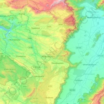
Name: Udumbanchola topographic map, elevation, terrain.
Location: Udumbanchola, Idukki, Kerala, India (9.63722 77.04139 10.08324 77.27289)
Average elevation: 833 m
Minimum elevation: 244 m
Maximum elevation: 2,438 m
Make a donation
Gear up for your next adventure:
As an Amazon Associate, this site earns from qualifying purchases at no extra cost to you.
Other topographic maps
Click on a map to view its topography, its elevation and its terrain.
Western Ghats
The range starts near south of the Tapti river and runs approximately 1,600 km (990 mi) through the states of Gujarat, Maharashtra, Karnataka, Goa, Kerala and Tamil Nadu ending at Marunthuvazh Malai, Swamithope near the southern tip of India. These hills cover 160,000 km2 (62,000 sq mi) and form the catchment…
Average elevation: 2,225 m
Thiruvananthapuram
India > Kerala > Thiruvananthapuram
Thiruvananthapuram is built on seven hills by the seashore and is at 8°30′N 76°54′E / 8.5°N 76.9°E / 8.5; 76.9 on the west coast, near the southern tip of mainland India. The city is on the west coast of India and is bounded by the Laccadive Sea to its west and the Western Ghats to its east.…
Average elevation: 33 m
Make a donation
Gear up for your next adventure:
As an Amazon Associate, this site earns from qualifying purchases at no extra cost to you.
Make a donation
Gear up for your next adventure:
As an Amazon Associate, this site earns from qualifying purchases at no extra cost to you.
Ernakulam
India > Kerala > Kanayannur
The Ernakulam District is situated in Central Kerala in India. Ernakulam is located at the geographic coordinates of 9°58′53.8″N 76°17′59.6″E / 9.981611°N 76.299889°E / 9.981611; 76.299889 and at an elevation of 22.36 m (73.4 ft) above the mean sea level.
Average elevation: 6 m
Make a donation
Gear up for your next adventure:
As an Amazon Associate, this site earns from qualifying purchases at no extra cost to you.
Thiruvananthapuram
India > Kerala > Thiruvananthapuram
Thiruvananthapuram is built on seven hills by the seashore and is at 8°30′N 76°54′E / 8.5°N 76.9°E / 8.5; 76.9 on the west coast, near the southern tip of mainland India. The city is on the west coast of India and is bounded by the Laccadive Sea to its west and the Western Ghats to its east.…
Average elevation: 33 m
Make a donation
Gear up for your next adventure:
As an Amazon Associate, this site earns from qualifying purchases at no extra cost to you.
Aluva
Aluva Railway Station (IR Code: AWY) is a grade-A station and the third busiest in Kochi after Ernakulam Junction railway station and Ernakulam Town railway station. Every passenger and express train bound for southern Kerala stops here. Travelers from the Idukki district typically use either the Aluva or the…
Average elevation: 11 m
Make a donation
Gear up for your next adventure:
As an Amazon Associate, this site earns from qualifying purchases at no extra cost to you.
Make a donation
Gear up for your next adventure:
As an Amazon Associate, this site earns from qualifying purchases at no extra cost to you.
Make a donation
Gear up for your next adventure:
As an Amazon Associate, this site earns from qualifying purchases at no extra cost to you.
Make a donation
Gear up for your next adventure:
As an Amazon Associate, this site earns from qualifying purchases at no extra cost to you.
Make a donation
Gear up for your next adventure:
As an Amazon Associate, this site earns from qualifying purchases at no extra cost to you.
Make a donation
Gear up for your next adventure:
As an Amazon Associate, this site earns from qualifying purchases at no extra cost to you.
Make a donation
Gear up for your next adventure:
As an Amazon Associate, this site earns from qualifying purchases at no extra cost to you.
Anamudi
Anamudi ("Elephant head", Malayalam: [aːnɐmuɖi]) is a mountain located in Ernakulam district and Idukki district of the Indian state of Kerala. With an elevation of 2,695 m (8,842 ft), it is the highest peak in the Western Ghats and in South India.
Average elevation: 2,209 m
Make a donation
Gear up for your next adventure:
As an Amazon Associate, this site earns from qualifying purchases at no extra cost to you.
Make a donation
Gear up for your next adventure:
As an Amazon Associate, this site earns from qualifying purchases at no extra cost to you.
Make a donation
Gear up for your next adventure:
As an Amazon Associate, this site earns from qualifying purchases at no extra cost to you.
Make a donation
Gear up for your next adventure:
As an Amazon Associate, this site earns from qualifying purchases at no extra cost to you.
Make a donation
Gear up for your next adventure:
As an Amazon Associate, this site earns from qualifying purchases at no extra cost to you.
Mannarkkad
Mannarkkad is located at 10°59′N 76°28′E / 10.98°N 76.47°E / 10.98; 76.47. It has an average elevation of 76 m (249 ft). Mannarkkad is located 36 km north-west of district headquarters Palakkad, along National Highway 966 and 100 km north west of Kozhikode. Mannarkkad is located in the…
Average elevation: 80 m
Nilambur
The 2,554 m (8,379 ft) m high Mukurthi peak, which is situated in the border of Nilambur Taluk and Ooty Taluk, and is also the fifth-highest peak in South India as well as the third-highest in Kerala after Anamudi (2,696 m [8,845 ft]) and Meesapulimala (2,651 m [8,698 ft]), is the highest point of elevation in…
Average elevation: 33 m
Make a donation
Gear up for your next adventure:
As an Amazon Associate, this site earns from qualifying purchases at no extra cost to you.
Kalpetta
Kalpetta is a city and town and Wayanad Grade 2 municipality in the Wayanad district of the Indian state of Kerala. Kalpetta is the headquarters of the Wayanad district, as well as the headquarters of Vythiri taluk. It is surrounded by dense coffee and tea plantations and mountains. It lies on the…
Average elevation: 809 m
Make a donation
Gear up for your next adventure:
As an Amazon Associate, this site earns from qualifying purchases at no extra cost to you.
Tirurangadi
India > Kerala > Tirurangadi
Tirurangadi is located at 11°03′N 75°56′E / 11.05°N 75.93°E / 11.05; 75.93. It has an average elevation of 10 m (33 ft).
Average elevation: 24 m
Make a donation
Gear up for your next adventure:
As an Amazon Associate, this site earns from qualifying purchases at no extra cost to you.
Make a donation
Gear up for your next adventure:
As an Amazon Associate, this site earns from qualifying purchases at no extra cost to you.
Make a donation
Gear up for your next adventure:
As an Amazon Associate, this site earns from qualifying purchases at no extra cost to you.
Make a donation
Gear up for your next adventure:
As an Amazon Associate, this site earns from qualifying purchases at no extra cost to you.
Pattithanam
Pattithanam is a village near Ettumanoor in the Kottayam District of Kerala, India. The name 'Pattithanam' is believed to be given by the Portuguese traders, who were looking for an ideal spot to build a church (St.Boniface Church). Pattithanam(Pattia Sthanam) means ideal place in Malayalam. Pattithanam…
Average elevation: 38 m
Make a donation
Gear up for your next adventure:
As an Amazon Associate, this site earns from qualifying purchases at no extra cost to you.
Make a donation
Gear up for your next adventure:
As an Amazon Associate, this site earns from qualifying purchases at no extra cost to you.
Edalipparakudy Tribal Settlement, Edamalakudy
India > Kerala > Kothamangalam
Average elevation: 1,192 m
Make a donation
Gear up for your next adventure:
As an Amazon Associate, this site earns from qualifying purchases at no extra cost to you.