
Morrow Island topographic map
Interactive map
Click on the map to display elevation.
About this map
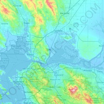
Name: Morrow Island topographic map, elevation, terrain.
Location: Morrow Island, Solano County, California, United States (37.79658 -122.40635 38.43658 -121.76635)
Average elevation: 98 m
Minimum elevation: -7 m
Maximum elevation: 1,136 m
Other topographic maps
Click on a map to view its topography, its elevation and its terrain.
San Diego
United States > California > San Diego County
San Diego is characterized by a diverse topography that features coastal plains, rolling hills, and rugged mountain ranges. The city is situated along the Pacific Ocean, where it boasts an extensive shoreline with sandy beaches and tidal zones. As you move inland, the landscape transitions from the flat…
Average elevation: 125 m
Los Angeles
United States > California > Los Angeles County
Los Angeles is characterized by a diverse and dynamic topography. The city is predominantly situated in a basin bordered by mountain ranges, including the Santa Monica Mountains to the north and the San Gabriel Mountains to the east, with elevations reaching up to about 10,000 feet (3,048 meters) in certain…
Average elevation: 241 m
San Francisco
San Francisco is characterized by its striking and varied topography, making it one of the most distinctive cities in the United States. The landscape features a mix of rolling hills and steep inclines, with the highest elevation reaching approximately 922 feet at Twin Peaks. The average elevation across the…
Average elevation: 63 m
Escondido
United States > California > San Diego County
Escondido has a borderline semi-arid climate (Köppen: Bsh) and hot-summer Mediterranean climate (Köppen: Csa) with hot summers and cool wet winters. Owing to its inland setting it is considerably warmer than coastal cities like San Diego, Carlsbad or Oceanside during the summertime, and cooler in the winter.…
Average elevation: 273 m
Berkeley
United States > California > Alameda County
Berkeley, located on the eastern shore of San Francisco Bay, features a diverse topography characterized by rolling hills and steep slopes. The city sits at an elevation that ranges from sea level along the bay to about 1,300 feet (396 meters) in the Berkeley Hills. This hilly landscape provides stunning views…
Average elevation: 109 m
Monterey
United States > California > Monterey County
During winter, snow occasionally falls in the higher elevations of the Santa Lucia Mountains and Gabilan Mountains that overlook Monterey, but snow in Monterey itself is extremely rare. A few unusual events in January 1962, February 1976, and December 1997 brought a light coating of snow to Monterey. In March…
Average elevation: 50 m
Eureka
United States > California > Humboldt County
Eureka, located along Humboldt Bay in Northern California, has a diverse and varied topography. The city itself is situated at relatively low elevations, with the bay’s narrow point serving as a key feature in the landscape. Its average elevation is around 50 feet (15 meters), and the terrain gently rises…
Average elevation: 18 m
Humboldt County
The coastal zone of the county experiences very wet, cool winters and dry, mild foggy summers. In the winter, temperatures range from highs of 40–59 °F (4–15 °C) to lows of 32–49 °F (0–9 °C). Coastal summers are cool to mild, with average highs of 60–69 °F (16–21 °C) and frequent fogs.…
Average elevation: 540 m
Newport Beach
United States > California > Orange County
Newport Beach, located in Orange County, California, features a dynamic and varied topography shaped by its coastal position and surrounding hills. The city spans from sea level along its beaches to elevations of over 1,100 feet (335 meters) in the nearby San Joaquin Hills. These hills, particularly noticeable…
Average elevation: 14 m
Sequoia National Park
United States > California > Tulare County
Many park visitors enter Sequoia National Park through its southern entrance near the town of Three Rivers at Ash Mountain at 1,700 ft (520 m) elevation. The lower elevations around Ash Mountain contain the only National Park Service-protected California Foothills ecosystem, consisting of blue oak woodlands,…
Average elevation: 2,515 m
San Diego County
San Diego County's topography is marked by its dramatic variety, ranging from coastal plains to mountainous regions. The county stretches along California's southern border, with a coastline that includes sandy beaches, cliffs, and bays, such as the iconic San Diego Bay. Inland, the terrain rises into the…
Average elevation: 544 m
Yosemite National Park
The geology of the Yosemite area is characterized by granite rocks and remnants of older rock. About 10 million years ago, the Sierra Nevada was uplifted and tilted to form its unique slopes, which increased the steepness of stream and river beds, resulting in the formation of deep, narrow canyons. About one…
Average elevation: 2,337 m
Los Angeles
United States > California > Los Angeles County
Los Angeles is characterized by a diverse and dynamic topography. The city is predominantly situated in a basin bordered by mountain ranges, including the Santa Monica Mountains to the north and the San Gabriel Mountains to the east, with elevations reaching up to about 10,000 feet (3,048 meters) in certain…
Average elevation: 241 m
Lone Pine
United States > California > Inyo County
Lone Pine is a census-designated place (CDP) in Inyo County, California, United States. Lone Pine is located 16 mi (26 km) south-southeast of Independence, at an elevation of 3,727 ft (1,136 m). The population was 2,035 at the 2010 census, up from 1,655 at the 2000 census. The town is located in the Owens…
Average elevation: 1,298 m
San Jose
United States > California > Santa Clara County
San Jose, located in Santa Clara County, California, features a diverse topography characterized by a mix of low-lying plains and rolling hills. The city sits at an average elevation of approximately 82 feet (25 meters) above sea level, with the surrounding terrain including the foothills of the Santa Cruz…
Average elevation: 264 m
Malibu
United States > California > Los Angeles County
The Malibu Coast lies on the fringe of an extensive chaparral and woodland wilderness area, the Santa Monica Mountains National Recreation Area. Various environmental elements collectively create a recipe for natural disasters: the mountainous and geologically unstable terrain; seasonal rainstorms that result…
Average elevation: 144 m
Los Angeles County
Los Angeles County's topography is characterized by a diverse landscape that includes coastal plains, mountain ranges, and expansive valleys. The county is situated within the Los Angeles Basin, a large sedimentary basin bounded by the Santa Monica Mountains to the north and the San Gabriel Mountains to the…
Average elevation: 378 m
Lake Tahoe
United States > California > Placer County
Lake Tahoe is renowned for its dramatic topography, characterized by rugged mountain ranges and deep, crystal-clear waters. Nestled in the Sierra Nevada, the lake itself lies at an elevation of approximately 6,225 feet (1,897 meters) and spans about 22 miles (35 kilometers) in length and 12 miles (19…
Average elevation: 2,077 m
Death Valley
Death Valley's Badwater Basin is the point of lowest elevation in North America, at 282 feet (86 m) below sea level. It is 84.6 miles (136.2 km) east-southeast of Mount Whitney — the highest point in the contiguous United States, with an elevation of 14,505 feet (4,421 m). On the afternoon of July 10, 1913,…
Average elevation: 1,085 m
Sonora
United States > California > Tuolumne County
Sonora is located at 37°59′04″N 120°22′54″W / 37.984361°N 120.381767°W / 37.984361; -120.381767, around the intersection of California State Highways 49 and 108 The altitude is 1,825 feet (556 m). According to the United States Census Bureau, the city has a total area of 3.1 square miles…
Average elevation: 615 m
Encinitas
United States > California > San Diego County
Encinitas lies on rugged coastal terrace. The city is bisected by a low-lying coastal ridge that separates New and Old Encinitas. In the north of the city, the coast rises in elevation and the land is raised up in the form of many coastal bluffs. These cliffs are subject to collapsing on the narrow beach. The…
Average elevation: 32 m
Palo Alto
United States > California > Santa Clara County
The official elevation is 30 feet (9 m) above sea level, but the city boundaries reach well into the peninsula hills.
Average elevation: 187 m
Santa Barbara
United States > California > Santa Barbara County
Annual rainfall totals are highly variable and in exceptional years like 1940–1941 and 1997–1998 over 40 inches (1.0 m) of rain have fallen in a year, but in dry seasons less than 6 inches (150 mm) is not unheard of. Snow sometimes covers higher elevations of the Santa Ynez Mountains but is extremely rare…
Average elevation: 119 m
Sonoma County
Sonoma County, as is often the case with coastal counties in California, has a great degree of climatic variation and numerous, often very different, microclimates. Key determining factors for local climate are proximity to the ocean, elevation, and the presence and elevation of hills or mountains to the east…
Average elevation: 210 m
Redding
United States > California > Shasta County
The elevation in Redding is 495 feet (151 meters) on average, whereas anywhere to the north, east, or west of downtown ranges between 550 feet (170 m) and 800 feet (240 m) feet. Southern portions range between 400 feet (120 m) and 500 feet (150 m).
Average elevation: 240 m
Yosemite National Park
The geology of the Yosemite area is characterized by granite rocks and remnants of older rock. About 10 million years ago, the Sierra Nevada was uplifted and tilted to form its unique slopes, which increased the steepness of stream and river beds, resulting in the formation of deep, narrow canyons. About one…
Average elevation: 2,337 m
Simi Valley
United States > California > Ventura County
Simi Valley is a city located in the very southeast corner of Ventura County, bordering the San Fernando Valley in Los Angeles County, and is a part of the Greater Los Angeles Area. The city of Simi Valley basically consists of the eponymous valley itself. The city of Simi Valley borders the Santa Susana…
Average elevation: 405 m
Death Valley
Death Valley's Badwater Basin is the point of lowest elevation in North America, at 282 feet (86 m) below sea level. It is 84.6 miles (136.2 km) east-southeast of Mount Whitney, the highest point in the contiguous United States, with an elevation of 14,505 feet (4,421 m). On the afternoon of July 10, 1913, the…
Average elevation: 1,085 m
Marine Corps Base Camp Pendleton
United States > California > San Diego County
Average elevation: 173 m
El Dorado Hills
United States > California > El Dorado County > Cameron Park
El Dorado Hills (EDH), as defined by the 2010 census-designated place (CDP), is at the western border of El Dorado County, between the City of Folsom and the unincorporated community of Cameron Park. The northern limits of the CDP are Folsom Lake and the South Fork of the American River, where river rafters…
Average elevation: 254 m
Pacific Palisades
United States > California > Los Angeles County > Los Angeles
Pacific Palisades was formally founded in 1921 by a Methodist organization, and in the years that followed became a refuge for Jewish artists and intellectuals fleeing the Holocaust. The Palisades would later be sought after by celebrities and other high-profile individuals seeking privacy. It is known for its…
Average elevation: 196 m
Oakland
United States > California > Alameda County
Oakland features a diverse topography shaped by its location along the eastern shore of San Francisco Bay and the presence of the nearby coastal hills. The city sits on a flat coastal plain that gradually ascends toward the Oakland Hills to the east, where elevations can exceed 1,700 feet. The highest point…
Average elevation: 51 m
Bakersfield
United States > California > Kern County
Most of Bakersfield's major streets are six-lane divided roads with bike lanes, with almost every street in the city having proper lane signage for bicycle traffic. Bikes are a popular method of transportation in Bakersfield, due to the city's relatively flat topography and grid-like street system. Newer…
Average elevation: 157 m
Oceanside
United States > California > San Diego County
Oceanside features a diverse topography characterized by its coastal setting and gentle inland elevations. The city is predominantly flat, with its elevation averaging around 66 feet (20 meters) above sea level, allowing for expansive views of the Pacific Ocean along its roughly 3.5 miles of coastline. Inland,…
Average elevation: 32 m
Pasadena
United States > California > Los Angeles County
An obscure portion of the Angeles Crest Highway (SR 2) in the San Gabriel Mountains cuts through Pasadena near the Angeles Crest Ranger Station. This 2-mile (3.2 km) stretch of highway in the Angeles National Forest is north of La Cañada Flintridge and west of Mount Wilson and is approximately 3,000 feet (910…
Average elevation: 548 m
Salinas
United States > California > Monterey County
Prior to mass agricultural and urban development, much of the city consisted of rolling hills bisected by wooded creeks and interspersed with marsh land. Today, the city is located mostly on leveled ground, with some rolling hills and wooded gulches with creeks remaining in the north-eastern Creekbridge and…
Average elevation: 19 m
Palm Springs
United States > California > Riverside County
One possible origin of palm in the place name comes from early Spanish explorers who referred to the area as La Palma de la Mano de Dios or "The Palm of God's hand". The earliest use of the name "Palm Springs" is from United States Topographical Engineers who used the term in 1853 maps. According to William…
Average elevation: 859 m
Sunnyvale
United States > California > Santa Clara County
According to the United States Census Bureau, the city has a total area of 22.7 sq mi (58.8 km2), of which, 22.0 sq mi (56.9 km2) of it is land and 0.69 sq mi (1.8 km2) of it (3.09%) is water. Its elevation is 130 feet above sea level.
Average elevation: 24 m
Santa Clara County
Santa Clara County features a diverse and varied topography characterized by both low-lying valleys and rugged mountainous regions. The county encompasses a significant portion of Silicon Valley, where flat, urbanized areas are interspersed with rolling hills and foothills that rise sharply in the Santa Cruz…
Average elevation: 323 m
Golden Gate Park
United States > California > San Francisco
In the 1860s, San Franciscans began to feel the need for a spacious public park similar to Central Park, which was then taking shape in New York City. Golden Gate Park was carved out of unpromising sand and shore dunes that were known as the Outside Lands, in an unincorporated area west of San Francisco's…
Average elevation: 71 m
Santa Catalina Island
United States > California > Los Angeles County > Avalon
Catalina is primarily composed of two distinct rock units: Catalina Schist from the Early Cretaceous (95 to 109 million years ago), and Miocene volcanic and intrusive igneous rocks. The island is rich in quartz, to the extent that some beaches on the seaward side have silvery-grey sand. These formations…
Average elevation: 60 m
Joshua Tree National Park
Joshua Tree National Park is an American national park in southeastern California, east of San Bernardino and Los Angeles and north of Palm Springs. It is named after the Joshua trees (Yucca brevifolia) native to the Mojave Desert. Originally declared a national monument in 1936, Joshua Tree was redesignated…
Average elevation: 639 m
Hemet
United States > California > Riverside County
Dedicated to James Simpson, Hemet City Council from 1947 to 48, and mayor from 1950 to 1966, Simpson Park is a wilderness park located in the Santa Rosa Hills southeast of Hemet with sheltered picnic area and tables, barbecues, restrooms, and hiking trails. At an elevation of 2,500 feet (760 m), it provides an…
Average elevation: 535 m
Paradise
United States > California > Butte County
Paradise lies within the foothills of the Sierra Nevada mountain range, at an elevation that varies between 900 and 2,300 feet (275 to 700 meters) above sea level. The town is perched on a broad ridge, with steep canyons on either side—these are carved by the Feather River to the east and Butte Creek to the…
Average elevation: 464 m
Bishop
United States > California > Inyo County
Bishop (formerly Bishop Creek) is a city in California, United States. It is the largest populated place and only incorporated city in Inyo County. Bishop is located near the northern end of the Owens Valley, at an elevation of 4,150 feet (1,260 m). The city was named after Bishop Creek, flowing out of the…
Average elevation: 1,265 m
Truckee
United States > California > Nevada County
Truckee is characterized by its dramatic topography set in the Sierra Nevada mountain range. The town sits at an elevation of approximately 5,817 feet (1,774 meters), surrounded by a stunning landscape of rugged mountains, rolling hills, and expansive forested areas. Prominent features include Donner Pass,…
Average elevation: 1,918 m
Oak Glen
United States > California > San Bernardino County
Oak Glen is a census-designated place situated within the San Bernardino Mountains in San Bernardino County, California, United States. Oak Glen is located 15 miles east of San Bernardino, at an elevation of 4,734 feet (1,443 m). The population was 602 at the 2020 census.
Average elevation: 1,502 m
Sonoma County
Sonoma County, as is often the case with coastal counties in California, has a great degree of climatic variation and numerous, often very different, microclimates. Key determining factors for local climate are proximity to the ocean, elevation, and the presence and elevation of hills or mountains to the east…
Average elevation: 210 m
South Lake Tahoe
United States > California > El Dorado County
According to the United States Census Bureau, the city has a total area of 16.6 square miles (43 km2), of which 10.2 square miles (26 km2) is land and 6.4 square miles (17 km2), or 38.80%, is water. Its elevation is about 6,237 feet (1,901 m) above sea level.
Average elevation: 1,979 m
Santa Clarita
United States > California > Los Angeles County
The official elevation of the city is 1,207 feet (368 m), the elevation of the historic Newhall Airport which was northwest of Via Princessa and Railroad Avenue from the 1930s through the 1950s. Elevation varies substantially throughout the city. The lowest point in Santa Clarita is near the junction of CA-126…
Average elevation: 514 m
Sacramento County
According to the U.S. Census Bureau, the county has a total area of 994 square miles (2,570 km2), of which 965 square miles (2,500 km2) is land and 29 square miles (75 km2) (3.0%) is water. Most of the county is at an elevation close to sea level, with some areas below sea level. The highest point in the…
Average elevation: 62 m