
Make a donation
Gear up for your next adventure:
As an Amazon Associate, this site earns from qualifying purchases at no extra cost to you.
Sonoma County topographic map
Click on the map to display elevation.
Make a donation
Gear up for your next adventure:
As an Amazon Associate, this site earns from qualifying purchases at no extra cost to you.
Sonoma County
Sonoma County, as is often the case with coastal counties in California, has a great degree of climatic variation and numerous, often very different, microclimates. Key determining factors for local climate are proximity to the ocean, elevation, and the presence and elevation of hills or mountains to the east and west. This is in large part due to the fact that, as throughout California, the prevailing weather systems and wind come normally from the Pacific Ocean, blowing in from the west and southwest, so that places closer to the ocean and on the windward side of higher elevations tend to receive more rain from autumn through spring and more summer wind and fog. This itself is partly a result of the presence of high and low pressures in inland California, with persistent high summer temperatures in the Central Valley, in particular, leading to low pressures, drawing in moist air from the Pacific, cooling into damp cool breezes and fog over the cold coastal water. Those places further inland and particularly in the lee of significant elevations tend to receive less rain and less, in some cases no, fog in the summer.
Make a donation
Gear up for your next adventure:
As an Amazon Associate, this site earns from qualifying purchases at no extra cost to you.
About this map
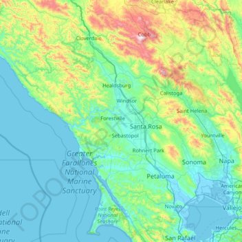
Name: Sonoma County topographic map, elevation, terrain.
Location: Sonoma County, California, United States (38.06953 -123.63250 38.85265 -122.34970)
Average elevation: 210 m
Minimum elevation: -4 m
Maximum elevation: 1,426 m
Make a donation
Gear up for your next adventure:
As an Amazon Associate, this site earns from qualifying purchases at no extra cost to you.
Other topographic maps
Click on a map to view its topography, its elevation and its terrain.
San Francisco Bay Area
United States > California > San Francisco
The San Francisco Bay Area is characterized by a diverse and dynamic topography shaped by geological processes over millions of years. This region features a combination of coastal plains, steep hills, and rugged mountains, all influenced by the tectonic activity associated with the nearby San Andreas Fault…
Average elevation: 113 m
Golden Gate Park
United States > California > San Francisco
In the 1860s, San Franciscans began to feel the need for a spacious public park similar to Central Park, which was then taking shape in New York City. Golden Gate Park was carved out of unpromising sand and shore dunes that were known as the Outside Lands, in an unincorporated area west of San Francisco's…
Average elevation: 71 m
El Dorado Hills
United States > California > El Dorado County > Cameron Park
El Dorado Hills (EDH), as defined by the 2010 census-designated place (CDP), is at the western border of El Dorado County, between the City of Folsom and the unincorporated community of Cameron Park. The northern limits of the CDP are Folsom Lake and the South Fork of the American River, where river rafters…
Average elevation: 254 m
Make a donation
Gear up for your next adventure:
As an Amazon Associate, this site earns from qualifying purchases at no extra cost to you.
Santa Cruz Mountains
United States > California > Santa Clara County
The Santa Cruz Mountains are a region of great biological diversity, encompassing cool, moist coastal ecosystems as well as warm, dry chaparral. Much of the area in the Santa Cruz mountains is considered temperate rainforest. In valleys and moist ocean-facing slopes some of the southernmost coast redwoods…
Average elevation: 230 m
Make a donation
Gear up for your next adventure:
As an Amazon Associate, this site earns from qualifying purchases at no extra cost to you.
Coachella Valley
United States > California > Riverside County > Palm Desert
The area is surrounded on the southwest by the Santa Rosa Mountains, by the San Jacinto Mountains to the west, the Little San Bernardino Mountains to the east and San Gorgonio Mountain to the north. These mountains peak at around 11,000 feet (3,400 m) and tend to average between 5,000 and 7,000 feet (1,500 and…
Average elevation: 72 m
Mount Shasta
United States > California > Siskiyou County
Mount Shasta (Shasta: Waka-nunee-Tuki-wuki; Karuk: Úytaahkoo) is a potentially active volcano at the southern end of the Cascade Range in Siskiyou County, California. At an elevation of 14,179 feet (4,321.8 meters), it is the second-highest peak in the Cascades and the fifth-highest in the state. Mount Shasta…
Average elevation: 3,717 m
Make a donation
Gear up for your next adventure:
As an Amazon Associate, this site earns from qualifying purchases at no extra cost to you.
Make a donation
Gear up for your next adventure:
As an Amazon Associate, this site earns from qualifying purchases at no extra cost to you.
Santa Monica Mountains
United States > California > Los Angeles County > Unincorporated Santa Monica Mountains
On January 17, 2007, an unusually cold storm brought snow in the Santa Monica Mountains. The hills above Malibu picked up three inches (eight centimeters) of snow - the first measurable snow in fifty years. Snow was reported on Boney Peak in the winter of 2005; and in March 2006, snow also fell on the summit…
Average elevation: 304 m
Make a donation
Gear up for your next adventure:
As an Amazon Associate, this site earns from qualifying purchases at no extra cost to you.
Mount Williamson
United States > California > Inyo County
Mount Williamson, at an elevation of 14,379 feet (4,383 m), is the second-highest mountain in both the Sierra Nevada range and the state of California, and the sixth-highest peak in the contiguous United States.
Average elevation: 3,821 m
Make a donation
Gear up for your next adventure:
As an Amazon Associate, this site earns from qualifying purchases at no extra cost to you.
Make a donation
Gear up for your next adventure:
As an Amazon Associate, this site earns from qualifying purchases at no extra cost to you.
Make a donation
Gear up for your next adventure:
As an Amazon Associate, this site earns from qualifying purchases at no extra cost to you.
Mount Baden-Powell
United States > California > Los Angeles County
At 9,407 feet (2,867 m) in elevation, Mount Baden-Powell is traditionally considered to be the 5th highest peak of the San Gabriel Range; however it is the second highest peak in the range with more than 1,000 feet (300 m) of prominence, and is the highest peak not part of the Mount San Antonio massif.
Average elevation: 2,429 m
Make a donation
Gear up for your next adventure:
As an Amazon Associate, this site earns from qualifying purchases at no extra cost to you.
Arrowbear Lake
United States > California > San Bernardino County > Running Springs
Arrowbear Lake is an unincorporated community in San Bernardino County, California, United States. Its altitude is 6,086 feet (1,855 m) in the San Bernardino Mountains. It is located east of Running Springs along Highway 18 in the San Bernardino National Forest, a mountain community with a population of 736 in…
Average elevation: 1,928 m
Make a donation
Gear up for your next adventure:
As an Amazon Associate, this site earns from qualifying purchases at no extra cost to you.
Make a donation
Gear up for your next adventure:
As an Amazon Associate, this site earns from qualifying purchases at no extra cost to you.
Big Sur
United States > California > Monterey County
The highest peaks of the crest of the coast range are located at an average distance from the coast of three and a half miles [5.6 km]. In this distance they rise to elevations of from three thousand six hundred to five thousand feet [1,100 to 1,500 m] above the sea-level. From San Carpoforo Creek to…
Average elevation: 193 m
Twain Harte
United States > California > Tuolumne County
Twain Harte is situated in Tuolumne County along Highway 108 at an elevation of 3,640 feet (1,110 m).
Average elevation: 1,123 m
Make a donation
Gear up for your next adventure:
As an Amazon Associate, this site earns from qualifying purchases at no extra cost to you.
Make a donation
Gear up for your next adventure:
As an Amazon Associate, this site earns from qualifying purchases at no extra cost to you.
Ramona
United States > California > San Diego County
In January 2006, Ramona Valley was designated the country's 162nd American Viticultural Area (AVA) by the Alcohol and Tobacco Tax and Trade Bureau, which recognized the area for its distinctive microclimate, elevation, and soil attributes.
Average elevation: 469 m
Make a donation
Gear up for your next adventure:
As an Amazon Associate, this site earns from qualifying purchases at no extra cost to you.
San Diego
United States > California > San Diego County > San Diego
The climate in San Diego, like most of Southern California, often varies significantly over short geographical distances, resulting in microclimates. In San Diego, this is mostly because of the city's topography (the Bay, and the numerous hills, mountains, and canyons). Frequently, particularly during the "May…
Average elevation: 57 m
Make a donation
Gear up for your next adventure:
As an Amazon Associate, this site earns from qualifying purchases at no extra cost to you.
Oak Spring Canyon Park
United States > California > Los Angeles County > Santa Clarita
Average elevation: 519 m
Make a donation
Gear up for your next adventure:
As an Amazon Associate, this site earns from qualifying purchases at no extra cost to you.
Make a donation
Gear up for your next adventure:
As an Amazon Associate, this site earns from qualifying purchases at no extra cost to you.
Tecopa Hot Springs
United States > California > Inyo County > Tecopa Hot Springs
Average elevation: 426 m
Make a donation
Gear up for your next adventure:
As an Amazon Associate, this site earns from qualifying purchases at no extra cost to you.
Crescent City
United States > California > Del Norte County
The topography of the sea floor surrounding Crescent City has the effect of focusing tsunamis. According to researchers at Humboldt State University and the University of Southern California, the city experienced tsunami conditions 31 times between the years 1933 and 2008. Although many of these incidents were…
Average elevation: 31 m
Oakhurst
United States > California > Madera County > Oakhurst
Oakhurst is located on the Fresno River 3 miles (5 km) south-southwest of Yosemite Forks, at an elevation of 2,274 feet (693 m). Its coordinates are 37°19′41″N 119°38′58″W / 37.32806°N 119.64944°W / 37.32806; -119.64944. It is located at the junction of state highways 41 and 49, at the…
Average elevation: 837 m
Make a donation
Gear up for your next adventure:
As an Amazon Associate, this site earns from qualifying purchases at no extra cost to you.
Make a donation
Gear up for your next adventure:
As an Amazon Associate, this site earns from qualifying purchases at no extra cost to you.
Green Valley
United States > California > Los Angeles County
Green Valley is an unincorporated community and census-designated place (CDP) in the Sierra Pelona Mountains, in Los Angeles County, California. It lies at an elevation of 2936 feet (895 m). The population was 1,036 at the 2020 census, up from 1,027 at the 2010 census.
Average elevation: 1,057 m
Make a donation
Gear up for your next adventure:
As an Amazon Associate, this site earns from qualifying purchases at no extra cost to you.
Posts
United States > California > Monterey County
Posts (formerly Posts Summit) is an unincorporated community in the Big Sur region of Monterey County, California. It is located on the Big Sur Coast Highway, 4.8 miles (7.7 km) south of the Big Sur Village at an elevation of 945 feet (288 m).
Average elevation: 251 m
Lockwood
United States > California > Monterey County
Lockwood is in southern Monterey County, 6 miles (10 km) east-southeast of Jolon, 1.8 miles (2.9 km) north of the mouth of Tule Canyon, 3.0 miles (4.8 km) north of the San Antonio River, and 9.3 miles (15.0 km) north of Bryson, at an elevation of 971 feet (296 m). It is 9 miles (14 km) northwest of Lake San…
Average elevation: 307 m
Make a donation
Gear up for your next adventure:
As an Amazon Associate, this site earns from qualifying purchases at no extra cost to you.
Make a donation
Gear up for your next adventure:
As an Amazon Associate, this site earns from qualifying purchases at no extra cost to you.
Bayshore Heights Park
United States > California > San Mateo County > Daly City
Average elevation: 84 m
Make a donation
Gear up for your next adventure:
As an Amazon Associate, this site earns from qualifying purchases at no extra cost to you.
Make a donation
Gear up for your next adventure:
As an Amazon Associate, this site earns from qualifying purchases at no extra cost to you.