
Cerro de Pasco topographic map
Interactive map
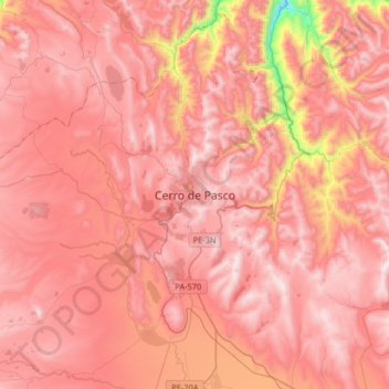
Click on the map to display elevation.
About this map
Name: Cerro de Pasco topographic map, elevation, terrain.
Average elevation: 4,239 m
Minimum elevation: 3,386 m
Maximum elevation: 4,602 m
Cerro de Pasco is a city in central Peru, located at the top of the Andean Mountains. It is the capital of both the Pasco Province and the Department of Pasco, and an important mining center of silver, copper, zinc and lead. At an elevation of 4,330 metres (14,210 ft), it is one of the highest cities in the world, and with a population of 58,899, it is the highest or the second highest city with over 50,000 inhabitants. The elevation reaches up to 4,380 metres or 14,370 feet in the Yanacancha area. The city has a very intense cold climate and it is connected by road and by rail (via Ferrocarril Central Andino) to the capital Lima, 300 kilometres or 190 miles away. Its urban area is formed by the districts of Chaupimarca, Yanacancha and Simón Bolívar.
Other topographic maps
Click on a map to view its topography, its elevation and its terrain.
Orellana
Peru > Pasco > Constitución
Orellana, Constitución, Province of Oxapampa, Pasco, Peru
Average elevation: 241 m
Villo
Peru > Pasco > Yanahuanca
Villo, Yanahuanca, Province of Daniel Carrión, Pasco, Peru
Average elevation: 3,764 m