
Pike County topographic map
Interactive map
Click on the map to display elevation.
Pike County
The terrain rises rapidly from the river valley in the east to the rolling foothills of the Poconos in the west. The highest point is one of two unnamed hills in Greene Township that top out at approximately 2,110 feet (643 m) above sea level. The lowest elevation is approximately 340 feet (103.6 m), at the confluence of the Bushkill and the Delaware rivers.
About this map
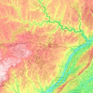
Name: Pike County topographic map, elevation, terrain.
Location: Pike County, Pennsylvania, United States (41.08135 -75.35900 41.60195 -74.68967)
Average elevation: 361 m
Minimum elevation: 97 m
Maximum elevation: 665 m
Other topographic maps
Click on a map to view its topography, its elevation and its terrain.
Smithville
United States > Pennsylvania > Lancaster County > Providence Township
Average elevation: 140 m
Caledonia State Park
United States > Pennsylvania > Franklin County > Greene Township
Average elevation: 367 m
East York
United States > Pennsylvania > York County > Springettsbury Township
Average elevation: 143 m
Lake Carey
United States > Pennsylvania > Wyoming County > Lemon Township > Lemon > Lake Carey
Average elevation: 323 m
East Texas
United States > Pennsylvania > Lehigh County > Lower Macungie Township
Average elevation: 126 m
Mount Nebo Park
United States > Pennsylvania > Monroe County > East Stroudsburg > Twin Falls
Average elevation: 185 m
Glen Summit
United States > Pennsylvania > Luzerne County > Fairview Township
Average elevation: 539 m
Elkdale
United States > Pennsylvania > Susquehanna County > Clifford Township
Average elevation: 463 m
Helen Furnace
United States > Pennsylvania > Clarion County > Highland Township
Average elevation: 441 m
Reinholds
United States > Pennsylvania > Lancaster County > West Cocalico Township
Average elevation: 159 m
Allison Park
United States > Pennsylvania > Allegheny County > Hampton Township
Average elevation: 324 m
Dalmatia
United States > Pennsylvania > Northumberland County > Lower Mahanoy Township
Average elevation: 172 m
York Mountain
United States > Pennsylvania > Warren County > Brokenstraw Township
Average elevation: 500 m
Dingmans Ferry
United States > Pennsylvania > Pike County > Delaware Township
Average elevation: 192 m
South Strabane
United States > Pennsylvania > Washington County > South Strabane Township
Average elevation: 377 m
Stevens
United States > Pennsylvania > Lancaster County > West Cocalico Township
Average elevation: 121 m
Langhorne Gardens
United States > Pennsylvania > Bucks County > Middletown Township
Average elevation: 45 m
Forest City Station
United States > Pennsylvania > Wayne County > Clinton Township
Average elevation: 531 m
Chadds Ford Township
United States > Pennsylvania > Delaware County > Chadds Ford Township
Average elevation: 101 m
Strawberry Mansion
United States > Pennsylvania > Philadelphia County > Philadelphia
Average elevation: 31 m
Morganville
United States > Pennsylvania > Montgomery County > Upper Moreland Township > Willow Grove
Average elevation: 81 m
South Mountain
United States > Pennsylvania > Lehigh County > Upper Saucon
Unlike Blue Mountain to its north, South Mountain does not follow a straight geographic line. The mountain ranges in elevation between 500 and 1,300 feet (150 and 400 m) above sea level. The ridge is made of metamorphic rocks and gneiss, which date to the Precambrian era and range from about 570 million to…
Average elevation: 153 m
Muncy Valley
United States > Pennsylvania > Sullivan County > Davidson Township
Average elevation: 378 m
Pleasureville
United States > Pennsylvania > York County > Springettsbury Township
Average elevation: 145 m
Elk Grove
United States > Pennsylvania > Columbia County > Sugarloaf Township
Average elevation: 534 m
Twin Lakes Park
United States > Pennsylvania > Westmoreland County > Hempfield Township > Luxor > Georges Station
Average elevation: 367 m
Linden
United States > Pennsylvania > Washington County > North Strabane Township
Average elevation: 331 m
Irving
United States > Pennsylvania > Schuylkill County > Pine Grove Township
Average elevation: 199 m
Baptism Creek Spring
United States > Pennsylvania > Chester County > North Coventry Township
Average elevation: 228 m
Coopersville
United States > Pennsylvania > Lancaster County > Sadsbury Township
Average elevation: 183 m
Circleville
United States > Pennsylvania > Westmoreland County > North Huntingdon Township
Average elevation: 333 m
Baumgardner
United States > Pennsylvania > Lancaster County > Pequea Township
Average elevation: 126 m
Lakeside
United States > Pennsylvania > Susquehanna County > New Milford Township
Average elevation: 478 m
Observatory Hill
United States > Pennsylvania > Allegheny County > Pittsburgh
Average elevation: 319 m
Woodhouse
United States > Pennsylvania > Susquehanna County > Dimock Township
Average elevation: 416 m
Roaring Brook
United States > Pennsylvania > Luzerne County > Hunlock Township
Average elevation: 337 m
11th and Pike Playground
United States > Pennsylvania > Berks County > Reading
Average elevation: 132 m
Nottingham County Park
United States > Pennsylvania > Chester County > West Nottingham Township
Average elevation: 137 m
Marble Hall
United States > Pennsylvania > Montgomery County > Whitemarsh Township
Average elevation: 64 m
Mount Zion
United States > Pennsylvania > Cumberland County > South Middleton Township
Average elevation: 179 m
Allegheny River Lock and Dam No. 2
United States > Pennsylvania > Allegheny County > O'Hara Township
Average elevation: 268 m
Franklinville
United States > Pennsylvania > Montgomery County > Whitpain Township
Average elevation: 94 m
Longwood Gardens
United States > Pennsylvania > Chester County > East Marlborough Township
Average elevation: 125 m
Gladwyne
United States > Pennsylvania > Montgomery County > Lower Merion Township
Average elevation: 92 m
Blue Mountain
United States > Pennsylvania > Schuylkill County > Washington Township
The ridge of Blue Mountain runs for 150 miles (240 km) through Pennsylvania, reaching an elevation of 2,270 feet (690 m) above sea level just north of the Pennsylvania Turnpike, near the borough of Newburg. Most of the ridgecrest, however, only reaches between 1,400 and 1,700 feet (430 and 520 m) in elevation.…
Average elevation: 226 m
Williamsburg
United States > Pennsylvania > Armstrong County > East Franklin Township
Average elevation: 319 m
Stoneybrooke Woods
United States > Pennsylvania > Allegheny County > Cheswick
Average elevation: 283 m
Blue Ridge
United States > Pennsylvania > Bucks County > Bristol Township > Levittown
Average elevation: 16 m
Stevens Point
United States > Pennsylvania > Susquehanna County > Harmony Township
Average elevation: 434 m
Highland Park Reservoir No. 2
United States > Pennsylvania > Allegheny County > Pittsburgh
Average elevation: 275 m
Madisonville
United States > Pennsylvania > Lackawanna County > Madison Township
Average elevation: 512 m
Ashmead Village
United States > Pennsylvania > Montgomery County > Cheltenham Township > Cheltenham
Average elevation: 51 m
Southampton
United States > Pennsylvania > Bucks County > Upper Southampton Township
Average elevation: 75 m
Pendle Hill
United States > Pennsylvania > Delaware County > Nether Providence Township
Average elevation: 61 m
Chestnut Crossroads
United States > Pennsylvania > Cumberland County > Southampton Township
Average elevation: 256 m
Atlas
United States > Pennsylvania > Northumberland County > Mount Carmel Township
Average elevation: 385 m
Alverton
United States > Pennsylvania > Westmoreland County > East Huntingdon Township
Average elevation: 361 m
Sunset
United States > Pennsylvania > Lebanon County > North Lebanon Township
Average elevation: 180 m
Saint Boniface
United States > Pennsylvania > Cambria County > Elder Township
Average elevation: 593 m
Park Place
United States > Pennsylvania > Schuylkill County > Mahanoy Township
Average elevation: 515 m
Blue Mountain
United States > Pennsylvania > Monroe County > Eldred Township
The ridge of Blue Mountain runs for 150 miles (240 km) through Pennsylvania, reaching an elevation of 2,270 feet (690 m) above sea level just north of the Pennsylvania Turnpike, near the borough of Newburg. Most of the ridgecrest, however, only reaches between 1,400 and 1,700 feet (430 and 520 m) in elevation.…
Average elevation: 242 m