
Bærum topographic map
Interactive map
Click on the map to display elevation.
Bærum
The highest point in Bærum is Vidvangshøgda at 60°01′27″N 10°29′02″E / 60.0242329°N 10.4838324°E / 60.0242329; 10.4838324 with an altitude of 552 metres (1,811 ft). The largest lake is Stovivatnet with an area of 0.420 square kilometres (0.162 sq mi) at 59°54′28″N 10°27′03″E / 59.9078776°N 10.4508305°E / 59.9078776; 10.4508305
About this map
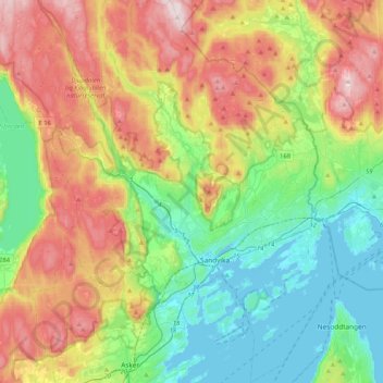
Name: Bærum topographic map, elevation, terrain.
Location: Bærum, Akershus, Norway (59.82574 10.34802 60.03223 10.65808)
Average elevation: 203 m
Minimum elevation: -1 m
Maximum elevation: 547 m
Other topographic maps
Click on a map to view its topography, its elevation and its terrain.