
The Pyramids topographic map
Interactive map
Click on the map to display elevation.
About this map
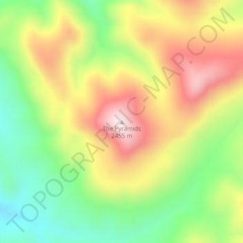
Name: The Pyramids topographic map, elevation, terrain.
Location: The Pyramids, Millard County, Utah, United States (38.67742 -112.49860 38.67752 -112.49850)
Average elevation: 2,185 m
Minimum elevation: 1,954 m
Maximum elevation: 2,442 m
Other topographic maps
Click on a map to view its topography, its elevation and its terrain.
Park City
United States > Utah > Summit County
In the summertime, many valley residents of the Wasatch Front visit the town to escape high temperatures. Park City is usually cooler than Salt Lake City as it lies mostly higher than 7,000 feet (2,100 m) above sea level, while Salt Lake City is situated at an elevation of about 4,300 feet (1,300 m).
Average elevation: 2,290 m
Salt Lake City
United States > Utah > Salt Lake County
Salt Lake City's topography is characterized by a striking contrast between its flat valley floor and the surrounding rugged mountains. The city is situated in the Salt Lake Valley, with an average elevation of approximately 4,237 feet above sea level, making it one of the higher major cities in the United…
Average elevation: 1,592 m
Park City
United States > Utah > Summit County
In the summertime, many valley residents of the Wasatch Front visit the town to escape high temperatures. Park City is usually cooler than Salt Lake City as it lies mostly higher than 7,000 feet (2,100 m) above sea level, while Salt Lake City is situated at an elevation of about 4,300 feet (1,300 m).
Average elevation: 2,290 m
Saint George
United States > Utah > Washington County
The St. George valley occasionally receives wet or slushy snowfall in the winter, but what accumulates usually melts off by the mid-to-late morning; the normal seasonal snowfall is 1.4 inches (3.6 cm). The earliest snowfall was measured on October 29, 1971, and the latest on April 11, 1927. The record…
Average elevation: 929 m
Moab
United States > Utah > Grand County
Moab is just south of the Colorado River, at an elevation of 4,025 feet (1,227 m) on the Colorado Plateau. It is 18 miles (29 km) west of the Utah/Colorado state line. Via U.S. Route 191, it is 31 miles (50 km) south of Interstate 70 at Crescent Junction, and it is 54 miles (87 km) north of Monticello. Via…
Average elevation: 1,357 m
Utah County
Utah Valley lies at the center of the county, lined by the mountains of the Wasatch Range on the east. Utah Lake occupies a large part of the valley. The elevation ranges from 4,487 feet (1,368 m) above sea level at the lake to 11,928 feet (3,636 m) at the peak of Mount Nebo.
Average elevation: 2,016 m
Cedar City
United States > Utah > Iron County
Cedar City is located in the southeast Great Basin and is approximately 20 miles (32 km) north of the northeastern edge of the Mojave Desert. Its elevation of 5,846 feet (1,782 m) gives it a somewhat cooler climate compared to the nearby St. George region, though it retains cultural ties to the city —for…
Average elevation: 1,975 m
Saint George
United States > Utah > Washington County
The St. George valley occasionally receives wet or slushy snowfall in the winter, but what accumulates usually melts off by the mid-to-late morning; the normal seasonal snowfall is 1.4 inches (3.6 cm). The earliest snowfall was measured on October 29, 1971, and the latest on April 11, 1927. The record…
Average elevation: 929 m
Ogden
United States > Utah > Weber County
According to the United States Census Bureau, the city has an area of 26.6 square miles (69.0 km2), all land. Elevations in the city range from about 4,300 to 5,000 feet (1,300 to 1,500 m) above sea level.
Average elevation: 1,498 m
Park City
United States > Utah > Summit County
In the summertime, many valley residents of the Wasatch Front visit the town to escape high temperatures. Park City is usually cooler than Salt Lake City as it lies mostly higher than 7,000 feet (2,100 m) above sea level, while Salt Lake City is situated at an elevation of about 4,300 feet (1,300 m).
Average elevation: 2,290 m
Provo
United States > Utah > Utah County
Provo lies in the Utah Valley at an elevation of 4,549 feet (1,387 m). According to the United States Census Bureau, the city has an area of 44.2 square miles (114.4 km2), of which 41.7 square miles (107.9 km2) is land and 2.5 square miles (6.5 km2), or 5.66%, is water.
Average elevation: 1,728 m
Moab
United States > Utah > Grand County
Moab is just south of the Colorado River, at an elevation of 4,025 feet (1,227 m) on the Colorado Plateau. It is 18 miles (29 km) west of the Utah/Colorado state line. Via U.S. Route 191, it is 31 miles (50 km) south of Interstate 70 at Crescent Junction, and it is 54 miles (87 km) north of Monticello. Via…
Average elevation: 1,357 m
Cache County
Cache County lies on the north edge of Utah. Its north border abuts the south border of the state of Idaho. On the western edge of the county are the Wellsville Mountains and on the eastern edge are the Bear River Mountains, both northern branches of the Wasatch Range. The Cache Valley reaches north to the…
Average elevation: 1,906 m
Bryce Canyon National Park
United States > Utah > Garfield County
Bryce Canyon National Park (/braɪs/) is an American national park located in southwestern Utah. The major feature of the park is Bryce Canyon, which despite its name, is not a canyon, but a collection of giant natural amphitheaters along the eastern side of the Paunsaugunt Plateau. Bryce is distinctive due to…
Average elevation: 2,259 m
Jordan River OHV/ Modelport State Park
United States > Utah > Salt Lake County > Salt Lake City
Average elevation: 1,286 m
Ogden
United States > Utah > Weber County
According to the United States Census Bureau, the city has an area of 26.6 square miles (69.0 km2), all land. Elevations in the city range from about 4,300 to 5,000 feet (1,300 to 1,500 m) above sea level.
Average elevation: 1,498 m
Provo
United States > Utah > Utah County
Provo lies in the Utah Valley at an elevation of 4,549 feet (1,387 m). According to the United States Census Bureau, the city has an area of 44.2 square miles (114.4 km2), of which 41.7 square miles (107.9 km2) is land and 2.5 square miles (6.5 km2), or 5.66%, is water.
Average elevation: 1,728 m
Escalante Petrified Forest State Park
United States > Utah > Garfield County > Escalante
Average elevation: 1,832 m
Orem
United States > Utah > Utah County
Orem is located at 40°17′56″N 111°41′47″W / 40.29889°N 111.69639°W / 40.29889; -111.69639 (40.298753, -111.696486). Situated in a high desert, with an average elevation of 4,756 feet. According to the United States Census Bureau, the city has a total area of 18.4 square miles (48 km2), all…
Average elevation: 1,458 m
Draper
United States > Utah > Salt Lake County
Draper's climate is roughly identical to other Salt Lake City suburbs. However, due to being further away from the Great Salt Lake, varied elevation, and from the downtown urban heat island effect, Draper experiences a slightly drier winter and more extremes in temperatures.
Average elevation: 1,570 m
Uintah County
Uintah County lies on the east side of Utah. Its eastern border abuts the western border of the state of Colorado. The Green River flows southwestward through the central part of the county and forms the lower part of Uintah County's border with Duchesne County. Two miles south of Ouray, Utah, it is joined by…
Average elevation: 2,055 m
Logan
United States > Utah > Cache County
The city lies near the eastern edge of Cache Valley on the western slopes of the Bear River Mountains. Mount Logan rises to an elevation of 9,710 feet (2,960 m) immediately to the east, and south of Logan Canyon. The eastern portions of the city are constructed on top of shelf-like "benches", late Pleistocene…
Average elevation: 1,498 m
Park City
United States > Utah > Summit County
In the summertime, many valley residents of the Wasatch Front visit the town to escape high temperatures. Park City is usually cooler than Salt Lake City as it lies mostly higher than 7,000 feet (2,100 m) above sea level, while Salt Lake City is situated at an elevation of about 4,300 feet (1,300 m).
Average elevation: 2,290 m
Wasatch Range
The range's highest point — 11,928 feet (3,636 m) — is Mount Nebo, a triple peak rising above Nephi, at the southern end of the range. In some places the mountains rise steeply from the valley's base elevation of 4,330 feet (1,320 m) to over 11,000 feet (3,400 m). Other notable peaks include Mount…
Average elevation: 1,882 m
Taylorsville
United States > Utah > Salt Lake County
The land on which Taylorsville is located is part of an interconnected alluvial plain that was formed by the wearing down of the Wasatch and Oquirrh Mountains to the east and west. Beneath the surface, Taylorsville sits on more than a kilometer of unconsolidated rock, sand, and clay. The inactive Taylorsville…
Average elevation: 1,325 m
Zion National Park
United States > Utah > Washington County
The 8,726-foot (2,660 m) summit of Horse Ranch Mountain is the highest point in the park; the lowest point is the 3,666-foot (1,117 m) elevation of Coal Pits Wash, creating a relief of about 5,100 feet (1,600 m).
Average elevation: 1,877 m
American Fork
United States > Utah > Utah County
Elevations throughout the city range from 4,566 feet (1,392 m) to 4,619 feet (1,408 m) above sea level.
Average elevation: 1,405 m
Zion National Park
United States > Utah > Washington County
The 8,726-foot (2,660 m) summit of Horse Ranch Mountain is the highest point in the park; the lowest point is the 3,666-foot (1,117 m) elevation of Coal Pits Wash, creating a relief of about 5,100 feet (1,600 m).
Average elevation: 1,877 m
Brighton
United States > Utah > Salt Lake County
Brighton has a high-altitude cold continental climate (Köppen Dsb/Dsc), with dry summers and very snowy winters.
Average elevation: 2,774 m
Cedar City
United States > Utah > Iron County
Cedar City is located in the southeast Great Basin and is approximately 20 miles (32 km) north of the northeastern edge of the Mojave Desert. Its elevation of 5,846 feet (1,782 m) gives it a somewhat cooler climate compared to the nearby St. George region, though it retains cultural ties to the city. For…
Average elevation: 1,975 m
Taylorsville
United States > Utah > Salt Lake County
The land on which Taylorsville is located is part of an interconnected alluvial plain that was formed by the wearing down of the Wasatch and Oquirrh Mountains to the east and west. Beneath the surface, Taylorsville sits on more than a kilometer of unconsolidated rock, sand, and clay. The inactive Taylorsville…
Average elevation: 1,325 m
Mapleton
United States > Utah > Utah County
According to the United States Census Bureau, the city has a total area of 12.6 square miles (32.6 km2), all land. The community lies at an elevation of 4,700 feet (1,400 m) above sea level.
Average elevation: 1,682 m
Cedar City
United States > Utah > Iron County
Cedar City is located in the southeast Great Basin and is approximately 20 miles (32 km) north of the northeastern edge of the Mojave Desert. Its elevation of 5,846 feet (1,782 m) gives it a somewhat cooler climate compared to the nearby St. George region, though it retains cultural ties to the city —for…
Average elevation: 1,975 m
Juab County
Juab County lies on the west side of Utah. Its west border abuts the east border of the state of Nevada. Its planar areas consist of rugged, arid semi-arable fine-grain soil, with hills and low mountains. Its eastern border is loosely defined by the ridgeline of an arm of the Wasatch Mountains. The terrain…
Average elevation: 1,647 m
Salt Lake City
United States > Utah > Salt Lake County
Salt Lake City has an area of 110.4 square miles (286 km2) and an average elevation of 4,327 feet (1,319 m) above sea level. The lowest point within the boundaries of the city is 4,210 feet (1,280 m) near the Jordan River and the Great Salt Lake, and the highest is Grandview Peak, at 9,410 feet (2,868 m).
Average elevation: 1,592 m
Beaver County
The Tushar Mountains lies on the eastern boundary of the county, reaching to 12,000 feet (3,700 m) in elevation and providing water for the farming communities of Beaver and Manderfield. To the west, barren desert valleys typify the scenery, separated by mountains lightly forested with junipers.
Average elevation: 1,843 m
South Jordan
United States > Utah > Salt Lake County
The relative flatness of South Jordan is due to lacustrine sediments of a pleistocene lake called Lake Bonneville. Lake Bonneville existed from 75,000 to 8,000 years ago; at its peak some 30,000 years ago, the lake reached an elevation of 5,200 feet (1,600 m) above sea level and had a surface area of 19,800…
Average elevation: 1,407 m
Tooele County
Tooele County lies on the west side of Utah. Its west border abuts the east border of the state of Nevada. Its northeast border abuts the Great Salt Lake. Three significant mountain ranges run north–south through the county. Its east boundary line is delineated by the crestline of the Oquirrh Mountains,…
Average elevation: 1,463 m
West Jordan
United States > Utah > Salt Lake County
West Jordan is a city in Salt Lake County, Utah, United States. It is a suburb of Salt Lake City and has a mixed economy. According to the 2020 Census, the city had a population of 116,961, placing it as the third most populous in the state. The city occupies the southwest end of the Salt Lake Valley at an…
Average elevation: 1,372 m
Uinta Mountains
The high Uintas were extensively glaciated during the last ice age, and most of the large stream valleys on both the north and south sides of the range held long valley glaciers. However, despite reaching to over 13,500 feet (4,110 m) in elevation, the climate today is sufficiently dry that no glaciers…
Average elevation: 2,363 m
Uintah County
Uintah County lies on the east side of Utah. Its eastern border abuts the western border of the state of Colorado. The Green River flows southwestward through the central part of the county and forms the lower part of Uintah County's border with Duchesne County. Two miles south of Ouray, Utah, it is joined by…
Average elevation: 2,055 m
Brian Head
United States > Utah > Iron County
The community, at an elevation of 9,800 feet (3,000 m) above sea level, is the highest town in Utah. It is located on State Route 143 and is east of Interstate 15. Brian Head is approximately three miles north of Cedar Breaks National Monument.
Average elevation: 3,031 m
Park City
United States > Utah > Summit County
In the summertime, many valley residents of the Wasatch Front visit the town to escape high temperatures. Park City is usually cooler than Salt Lake City as it lies mostly higher than 7,000 feet (2,100 m) above sea level, while Salt Lake City is situated at an elevation of about 4,300 feet (1,300 m).
Average elevation: 2,290 m