
Cattaraugus Creek topographic map
Interactive map
Click on the map to display elevation.
About this map
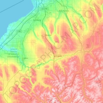
Name: Cattaraugus Creek topographic map, elevation, terrain.
Location: Cattaraugus Creek, Wyoming, New York, 14070, United States (42.43812 -79.13962 42.62888 -78.33388)
Average elevation: 411 m
Minimum elevation: 172 m
Maximum elevation: 721 m
Other topographic maps
Click on a map to view its topography, its elevation and its terrain.
Central Park
United States > New York > New York County > New York
In June 1856, Fernando Wood appointed a "consulting board" of seven people, headed by author Washington Irving, to inspire public confidence in the proposed development. Wood hired military engineer Egbert Ludovicus Viele as the park's chief engineer, tasking him with a topographical survey of the site. The…
Average elevation: 26 m
Niagara Escarpment
United States > New York > Niagara County > City of Lockport
Average elevation: 149 m
Central Park
United States > New York > New York County > New York
In June 1856, Fernando Wood appointed a "consulting board" of seven people, headed by author Washington Irving, to inspire public confidence in the proposed development. Wood hired military engineer Egbert Ludovicus Viele as the park's chief engineer, tasking him with a topographical survey of the site. The…
Average elevation: 26 m
Platte Clove
United States > New York > Greene County > Town of Hunter > Platte Clove Bruderhof
Average elevation: 575 m
Fort Edward Feeder Canal
United States > New York > Washington County > Village of Fort Edward
Average elevation: 57 m
Coney Island
United States > New York > Saint Lawrence County > Town of Pierrepont
Average elevation: 174 m
Buckhout Corners
United States > New York > Westchester County > Village of Briarcliff Manor
Average elevation: 112 m
Mohegan Heights
United States > New York > Westchester County > City of Yonkers
Average elevation: 58 m
Cooper Lake
United States > New York > Ulster County > Town of Woodstock > Lake Hill
Average elevation: 367 m
Kaaterskill High Peak
United States > New York > Greene County > Town of Hunter
Average elevation: 850 m
Harbor Hills Park
United States > New York > Nassau County > Village of Great Neck Estates
Average elevation: 10 m
Cowdens Corner
United States > New York > Chautauqua County > Town of Arkwright
Average elevation: 389 m
Constantia Center
United States > New York > Oswego County > Town of Constantia
Average elevation: 169 m
South New Berlin
United States > New York > Chenango County > Town of New Berlin
Average elevation: 380 m
Woodcock Mountain
United States > New York > Saratoga County > Town of Hadley
Average elevation: 271 m
Ellenburg Mountain
United States > New York > Clinton County > Town of Ellenburg
Average elevation: 682 m
Niagara Escarpment
United States > New York > Niagara County > City of Lockport
Average elevation: 149 m
Lake Katonah
United States > New York > Westchester County > Town of Lewisboro
Average elevation: 127 m
Mount Marcy
United States > New York > Essex County > Town of Keene
Mount Marcy is the highest point in the Adirondack Mountains and the U.S. state of New York, with an elevation of 5,343.1 feet (1,628.6 m). It is located in the town of Keene in Essex County. The mountain is in the heart of the High Peaks Wilderness Area in Adirondack Park. Like the surrounding Adirondack…
Average elevation: 1,289 m
West Coxsackie
United States > New York > Greene County > Village of Coxsackie
Average elevation: 33 m
Ontario Pond
United States > New York > Niagara County > City of North Tonawanda
Average elevation: 177 m
West Genesee Terrace
United States > New York > Onondaga County > Fairmount > Town of Camillus
Average elevation: 167 m