
Jenin topographic map
Interactive map
Click on the map to display elevation.
About this map
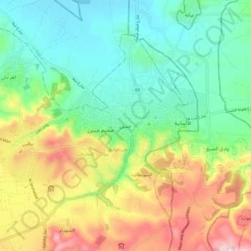
Name: Jenin topographic map, elevation, terrain.
Location: Jenin, Area A, West Bank, 180, Palestinian Territories (32.30188 35.13757 32.62188 35.45757)
Average elevation: 223 m
Minimum elevation: -140 m
Maximum elevation: 762 m
Jenin is situated at the foot of the rugged northernmost hills (Jabal Nablus) of the West Bank, and along the southern edge of the Jezreel Valley (Marj Ibn Amer),[65] which the city overlooks.[66] Its highest elevation is about 250 meters above sea level and its lowest areas are 90 meters above sea level.[67] Immediately southwest of Jenin is the Sahl Arraba plain (Dothan Valley), while further south is the Marj Sanur valley.[68] About 1.5 kilometers to Jenin's east is Mount Gilboa (Jabal Faqqua).[69]
Other topographic maps
Click on a map to view its topography, its elevation and its terrain.
Ein Alsultan Refugee Camp
Palestinian Territories > Area A > Jericho
Ein Alsultan Refugee Camp, Jericho, Area A, West Bank, Palestinian Territories
Average elevation: -169 m
Bethlehem
Palestinian Territories > Area A > Bethlehem
Bethlehem, Area A, West Bank, Palestinian Territories
Average elevation: 553 m
Jericho
Palestinian Territories > Area A
Jericho, Area A, West Bank, Palestinian Territories
Average elevation: -244 m
Nablus
Palestinian Territories > Area A
Nablus, Area A, West Bank, Palestinian Territories
Average elevation: 645 m
Albireh
Palestinian Territories > Area A
Albireh, Area A, West Bank, 611, Palestinian Territories
Average elevation: 811 m