
Bellingham topographic map
Interactive map
Click on the map to display elevation.
Bellingham
According to the United States Census Bureau, the city has a total area of 28.90 square miles (74.85 km2), of which, 27.08 square miles (70.14 km2) is land and 1.82 square miles (4.71 km2) is water. The lowest elevations are at sea level along the waterfront. Alabama Hill is one of the higher points in the city at about 500 feet (150 m). Elevations of 800 feet (240 m) are found near Yew Street Hill north of Lake Padden and near Galbraith Mountain. South and eastward of the city limits are taller foothills of the North Cascades mountains. Mount Baker is the largest peak in the local area, with a summit elevation of 10,778 feet (3,285 m) that is only 31 miles (50 km) from Bellingham Bay. Mount Baker is visible from many parts of the city and western Whatcom County. Lake Whatcom forms part of the eastern boundary of the city, while many smaller lakes and wetland areas are found around the region.
About this map
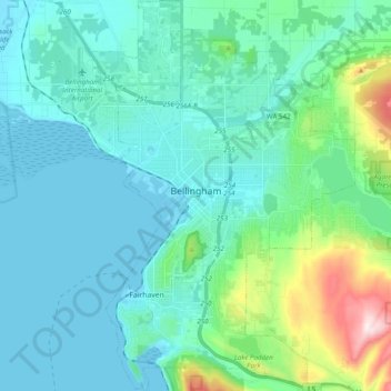
Name: Bellingham topographic map, elevation, terrain.
Location: Bellingham, Whatcom County, Washington, United States (48.68801 -122.53146 48.81741 -122.39871)
Average elevation: 89 m
Minimum elevation: -6 m
Maximum elevation: 540 m
Other topographic maps
Click on a map to view its topography, its elevation and its terrain.
Mount Redoubt
United States > Washington > Whatcom County
The North Cascades features some of the most rugged topography in the Cascade Range with craggy peaks, spires, ridges, and deep glacial valleys. Geological events occurring many years ago created the diverse topography and drastic elevation changes over the Cascade Range leading to the various climate…
Average elevation: 2,070 m
Bellingham
United States > Washington > Whatcom County > Bellingham
According to the United States Census Bureau, the city has a total area of 28.90 square miles (74.85 km2), of which, 27.08 square miles (70.14 km2) is land and 1.82 square miles (4.71 km2) is water. The lowest elevations are at sea level along the waterfront. Alabama Hill is one of the higher points in the…
Average elevation: 129 m