
Pangbourne topographic map
Interactive map
Click on the map to display elevation.
About this map
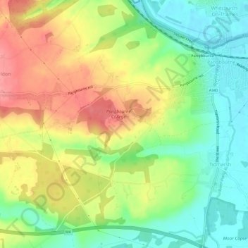
Name: Pangbourne topographic map, elevation, terrain.
Location: Pangbourne, West Berkshire, England, United Kingdom (51.45962 -1.12757 51.49017 -1.07083)
Average elevation: 64 m
Minimum elevation: 37 m
Maximum elevation: 120 m
West Berkshire trails, hiking, mountain biking, running and outdoor activities
Other topographic maps
Click on a map to view its topography, its elevation and its terrain.
Leckhampstead Thicket
United Kingdom > England > West Berkshire > Leckhampstead
Average elevation: 156 m
Walbury Hill
United Kingdom > England > West Berkshire
Walbury Hill is a summit of the North Wessex Downs in Berkshire, England. With an elevation of 297 metres (974 ft), it is the highest natural point in South East England. On the hill's summit is the Iron Age hill fort of Walbury Camp, whilst the flanks of the hill lie within the Inkpen and Walbury Hills SSSI.…
Average elevation: 222 m
Aldermaston Wharf
United Kingdom > England > West Berkshire > Aldermaston Wharf
Average elevation: 69 m