
Sanremo topographic map
Interactive map
Click on the map to display elevation.
About this map
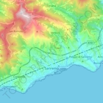
Name: Sanremo topographic map, elevation, terrain.
Location: Sanremo, Imperia, Liguria, Italy (43.79596 7.70824 43.87646 7.84703)
Average elevation: 312 m
Minimum elevation: -1 m
Maximum elevation: 1,279 m
Other topographic maps
Click on a map to view its topography, its elevation and its terrain.
Ventimiglia
Italy > Liguria > Imperia > Ventimiglia
Ventimiglia, Imperia, Liguria, Italy
Average elevation: 202 m
Bussana Vecchia
Italy > Liguria > Imperia > Sanremo > Poggio di Sanremo > Bussana Vecchia
Bussana Vecchia, Poggio di Sanremo, Sanremo, Imperia, Liguria, 18011, Italy
Average elevation: 114 m
Arma di Taggia
Arma di Taggia, Taggia, Imperia, Liguria, 18011, Italy
Average elevation: 54 m