
Suffolk County topographic map
Interactive map
Click on the map to display elevation.
Suffolk County
The highest elevation in the county, and on Long Island as a whole, is Jayne's Hill in West Hills, at 401 feet (122 m) above sea level. This low lying-geography means that much of the county is vulnerable to sea level rise.
About this map
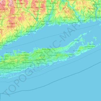
Name: Suffolk County topographic map, elevation, terrain.
Location: Suffolk County, New York, United States (40.55662 -73.49702 41.31055 -71.79097)
Average elevation: 34 m
Minimum elevation: -4 m
Maximum elevation: 396 m
Other topographic maps
Click on a map to view its topography, its elevation and its terrain.
Central Park
United States > New York > New York County > New York
In June 1856, Fernando Wood appointed a "consulting board" of seven people, headed by author Washington Irving, to inspire public confidence in the proposed development. Wood hired military engineer Egbert Ludovicus Viele as the park's chief engineer, tasking him with a topographical survey of the site. The…
Average elevation: 26 m
Tug Hill
United States > New York > Oswego County
The core Tug Hill region encompasses 150,000 acres (610 km2) of unbroken, generally second-growth, northern hardwood forest, and is drained by a vast network of streams. Important rivers and streams whose headwaters are located within the Tug Hill region include the Mohawk River, Deer River, Salmon River, Mad…
Average elevation: 109 m
Roberto Clemente State Park
United States > New York > Bronx County > New York
Average elevation: 32 m
Catskills Visitor Center
United States > New York > Ulster County > Town of Shandaken > Beechford
Average elevation: 301 m
Fisherman's Landing
United States > New York > Erie County > Town of Grand Island > Grandyle Village
Average elevation: 179 m
Barberville
United States > New York > Rensselaer County > Town of Poestenkill
Average elevation: 269 m
Central Park
United States > New York > New York County > New York
In June 1856, Fernando Wood appointed a "consulting board" of seven people, headed by author Washington Irving, to inspire public confidence in the proposed development. Wood hired military engineer Egbert Ludovicus Viele as the park's chief engineer, tasking him with a topographical survey of the site. The…
Average elevation: 26 m
Benjamin's Memorial Beach
United States > New York > Suffolk County > Bay Shore
Average elevation: 2 m
Vails Gate Junction
United States > New York > Orange County > Town of New Windsor > Vails Gate
Average elevation: 92 m
Benjamin's Memorial Beach
United States > New York > Suffolk County > Bay Shore
Average elevation: 2 m
Chestnut Ridge Park
United States > New York > Erie County > Town of Orchard Park
Average elevation: 314 m
Whitehall Corners
United States > New York > Westchester County > Town of Somers
Average elevation: 97 m
Ellicottville
United States > New York > Cattaraugus County > Village of Ellicottville
Average elevation: 573 m
Niagara Escarpment
United States > New York > Niagara County > City of Lockport
Average elevation: 149 m
Beechmont
United States > New York > Westchester County > City of New Rochelle
Average elevation: 31 m
Trumbull Corners
United States > New York > Tompkins County > Town of Newfield
Average elevation: 443 m
West Saint Johnsville
United States > New York > Montgomery County > Town of Saint Johnsville
Average elevation: 151 m
Whitehall Corners
United States > New York > Westchester County > Town of Somers
Average elevation: 97 m
Lake Tonetta
United States > New York > Putnam County > Brewster > Brewster Hill
Average elevation: 155 m
Sunset Ridge
United States > New York > Westchester County > Town/Village of Harrison
Average elevation: 27 m
Eastport South Manor Athletic Complex
United States > New York > Suffolk County > Town of Brookhaven > Eastport
Average elevation: 15 m
Lee Town Park
United States > New York > Oneida County > Lake Delta > Town of Lee
Average elevation: 184 m
Heath Ridge
United States > New York > Westchester County > Village of Scarsdale
Average elevation: 66 m
Barnum Corners
United States > New York > Putnam County > Town of Patterson > Putnam Lake
Average elevation: 174 m