
Suffolk County topographic map
Interactive map
Click on the map to display elevation.
About this map
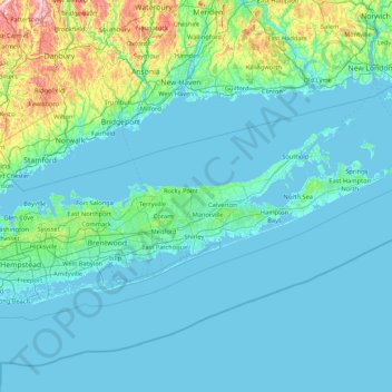
Name: Suffolk County topographic map, elevation, terrain.
Location: Suffolk County, New York, United States (40.55662 -73.49702 41.31055 -71.79097)
Average elevation: 34 m
Minimum elevation: -4 m
Maximum elevation: 396 m
The highest elevation in the county, and on Long Island as a whole, is Jayne's Hill in West Hills, at 401 feet (122 m) above sea level. This low lying-geography means that much of the county is vulnerable to sea level rise.
Other topographic maps
Click on a map to view its topography, its elevation and its terrain.
Staten Island
United States > New York > New York
Staten Island, Richmond County, New York, United States
Average elevation: 9 m
Queens County
United States > New York > New York
Queens County, New York, United States
Average elevation: 11 m
West Elmira
United States > New York > Chemung County
West Elmira, Town of Elmira, Chemung County, New York, 14905, United States
Average elevation: 320 m
Brooklyn
United States > New York > New York
Brooklyn, Kings County, New York, United States
Average elevation: 9 m
Central Park
United States > New York > New York County > New York
Central Park, New York County, New York, United States
Average elevation: 26 m
Bronx County
United States > New York > New York
Bronx County, The Bronx, New York, United States
Average elevation: 21 m
Manhattan
United States > New York > New York County > New York
Manhattan, New York County, New York, United States
Average elevation: 16 m
City of Albany
United States > New York > Albany County
City of Albany, Albany County, New York, United States
Average elevation: 68 m
Chautauqua County
Chautauqua County, New York, United States
Average elevation: 328 m
Buffalo
United States > New York > Erie County
Buffalo, Erie County, New York, United States
Average elevation: 185 m
Village of Castile
United States > New York > Wyoming County
Village of Castile, Town of Castile, Wyoming County, New York, United States
Average elevation: 420 m
Onondaga County
Onondaga County, New York, United States
Average elevation: 233 m
Steuben County
Steuben County, New York, United States
Average elevation: 488 m
East Aurora
United States > New York > Erie County
East Aurora, Town of Aurora, Erie County, New York, 14052, United States
Average elevation: 283 m
Village of Amityville
United States > New York > Suffolk County > Town of Babylon
Village of Amityville, Town of Babylon, Suffolk County, New York, United States
Average elevation: 6 m
Village of Evans Mills
United States > New York > Jefferson County
Village of Evans Mills, Town of Le Ray, Jefferson County, New York, United States
Average elevation: 139 m
City of Kingston
United States > New York > Ulster County
City of Kingston, Ulster County, New York, 12401, United States
Average elevation: 52 m
Town of Nanticoke
United States > New York > Broome County
Town of Nanticoke, Broome County, New York, 13777, United States
Average elevation: 396 m
Carle Place
United States > New York > Nassau County
Carle Place, Town of North Hempstead, Nassau County, New York, 11514, United States
Average elevation: 34 m
Town of Marbletown
United States > New York > Ulster County
Town of Marbletown, Ulster County, New York, United States
Average elevation: 126 m
East Shoreham
United States > New York > Suffolk County > Town of Brookhaven
East Shoreham, Town of Brookhaven, Suffolk County, New York, 11786, United States
Average elevation: 26 m
Town of Mexico
United States > New York > Oswego County
Town of Mexico, Oswego County, New York, 13114, United States
Average elevation: 119 m
City of Fulton
United States > New York > Oswego County
City of Fulton, Oswego County, New York, 13069, United States
Average elevation: 114 m
Just Room Enough Island
United States > New York > Jefferson County > Village of Alexandria Bay
Just Room Enough Island, Village of Alexandria Bay, Town of Alexandria, Jefferson County, New York, United States
Average elevation: 78 m
Village of Babylon
United States > New York > Suffolk County > Town of Babylon
Village of Babylon, Town of Babylon, Suffolk County, New York, 11702, United States
Average elevation: 4 m
Town of Mount Morris
United States > New York > Livingston County
Town of Mount Morris, Livingston County, New York, 14510, United States
Average elevation: 267 m
Hopewell Junction
United States > New York > Dutchess County > Town of East Fishkill
Hopewell Junction, Town of East Fishkill, Dutchess County, New York, United States
Average elevation: 83 m
City of New Rochelle
United States > New York > Westchester County
City of New Rochelle, Westchester County, New York, United States
Average elevation: 31 m
Town of Westville
United States > New York > Franklin County
Town of Westville, Franklin County, New York, United States
Average elevation: 79 m
Town of Ancram
United States > New York > Columbia County
Town of Ancram, Columbia County, New York, 12503, United States
Average elevation: 196 m
Kaiser Park
United States > New York > New York
Kaiser Park, Brooklyn, Kings County, New York, United States
Average elevation: 2 m
Bear Mountain
United States > New York > Essex County
Bear Mountain, Town of Schroon, Essex County, New York, 12858, United States
Average elevation: 365 m
Grand Island
Grand Island, Erie, New York, United States
Average elevation: 177 m
Town of Binghamton
United States > New York > Broome County
Town of Binghamton, Broome County, New York, 13903, United States
Average elevation: 417 m
Burke Center
United States > New York > Franklin County
Burke Center, Town of Burke, Franklin County, New York, 12917, United States
Average elevation: 217 m
Town of Spencer
United States > New York > Tioga County
Town of Spencer, Tioga County, New York, United States
Average elevation: 408 m
Town of Watertown
United States > New York > Jefferson County
Town of Watertown, Jefferson County, New York, United States
Average elevation: 189 m
Town of Cairo
United States > New York > Greene County
Town of Cairo, Greene County, New York, United States
Average elevation: 255 m
Bellmore
United States > New York > Nassau County
Bellmore, Town of Hempstead, Nassau County, New York, 11710, United States
Average elevation: 4 m
Waverly Glen Park
United States > New York > Tioga County > Waverly
Waverly Glen Park, Waverly, Town of Barton, Tioga County, New York, United States
Average elevation: 295 m
Village of Potsdam
United States > New York > Saint Lawrence County > Town of Potsdam
Village of Potsdam, Town of Potsdam, Saint Lawrence County, New York, 13699, United States
Average elevation: 133 m
Hampton Park
United States > New York > Suffolk County > North Sea > Town of Southampton
Hampton Park, North Sea, Town of Southampton, Suffolk County, New York, 11968, United States
Average elevation: 17 m
Rhinecliff
United States > New York > Dutchess County > Town of Rhinebeck
Rhinecliff, Town of Rhinebeck, Dutchess County, New York, 12574, United States
Average elevation: 19 m
Gansevoort
United States > New York > Saratoga County
Gansevoort, Town of Northumberland, Saratoga County, New York, United States
Average elevation: 69 m
Town of Hartwick
United States > New York > Otsego County
Town of Hartwick, Otsego County, New York, United States
Average elevation: 489 m