
Carrauntoohil topographic map
Interactive map
Click on the map to display elevation.
Carrauntoohil
Carrauntoohil is the highest mountain in Ireland on all classification scales. It is the 133rd-highest mountain, and 4th most prominent mountain, in Britain and Ireland, on the Simms classification. Carrauntoohil is regarded by the Scottish Mountaineering Club (SMC) as one of 34 Furths, which are defined as mountains above 3,000 feet (910 m) in elevation and meeting the SMC criteria for a Munro (i.e. "sufficient separation"), and which are outside (or furth), of Scotland; this is why Carrauntoohil is also referred to as one of the thirteen Irish Munros.
About this map
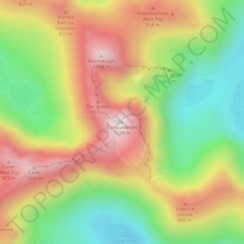
Name: Carrauntoohil topographic map, elevation, terrain.
Average elevation: 644 m
Minimum elevation: 298 m
Maximum elevation: 1,017 m
Other topographic maps
Click on a map to view its topography, its elevation and its terrain.
Dingle
Dingle's St. Mary's is a neo-Gothic church built to designs by J. J. McCarthy and O'Connell. The foundation stone was laid in 1862. It originally had a nave and aisles separated by arcades, supported on columns capped by octagonal tops. The arcades were demolished in one of the most radical reordering schemes…
Average elevation: 41 m