
Make a donation
Gear up for your next adventure:
As an Amazon Associate, this site earns from qualifying purchases at no extra cost to you.
Cockscomb topographic map
Click on the map to display elevation.
Make a donation
Gear up for your next adventure:
As an Amazon Associate, this site earns from qualifying purchases at no extra cost to you.
About this map
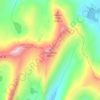
Name: Cockscomb topographic map, elevation, terrain.
Location: Cockscomb, Mariposa County, California, United States (37.83544 -119.38473 37.83554 -119.38463)
Average elevation: 3,113 m
Minimum elevation: 2,893 m
Maximum elevation: 3,388 m
Make a donation
Gear up for your next adventure:
As an Amazon Associate, this site earns from qualifying purchases at no extra cost to you.
Other topographic maps
Click on a map to view its topography, its elevation and its terrain.
Los Angeles
United States > California > Los Angeles County
Los Angeles is characterized by a diverse and dynamic topography. The city is predominantly situated in a basin bordered by mountain ranges, including the Santa Monica Mountains to the north and the San Gabriel Mountains to the east, with elevations reaching up to about 10,000 feet (3,048 meters) in certain…
Average elevation: 241 m
San Francisco
San Francisco is characterized by its striking and varied topography, making it one of the most distinctive cities in the United States. The landscape features a mix of rolling hills and steep inclines, with the highest elevation reaching approximately 922 feet at Twin Peaks. The average elevation across the…
Average elevation: 65 m
San Diego
United States > California > San Diego County
San Diego is characterized by a diverse topography that features coastal plains, rolling hills, and rugged mountain ranges. The city is situated along the Pacific Ocean, where it boasts an extensive shoreline with sandy beaches and tidal zones. As you move inland, the landscape transitions from the flat…
Average elevation: 125 m
Make a donation
Gear up for your next adventure:
As an Amazon Associate, this site earns from qualifying purchases at no extra cost to you.
Death Valley National Park
There are two major valleys in the park, Death Valley and Panamint Valley. Both of these valleys were formed within the last few million years and both are bounded by north–south-trending mountain ranges. These and adjacent valleys follow the general trend of Basin and Range topography with one modification:…
Average elevation: 1,171 m
Monterey
United States > California > Monterey County
During winter, snow occasionally falls in the higher elevations of the Santa Lucia Mountains and Gabilan Mountains that overlook Monterey, but snow in Monterey itself is extremely rare. A few unusual events in January 1962, February 1976, and December 1997 brought a light coating of snow to Monterey. In March…
Average elevation: 50 m
Death Valley
Death Valley's Badwater Basin is the point of lowest elevation in North America, at 282 feet (86 m) below sea level. It is 84.6 miles (136.2 km) east-southeast of Mount Whitney, the highest point in the contiguous United States, with an elevation of 14,505 feet (4,421 m). On the afternoon of July 10, 1913, the…
Average elevation: 1,085 m
Los Angeles
United States > California > Los Angeles County
Los Angeles is characterized by a diverse and dynamic topography. The city is predominantly situated in a basin bordered by mountain ranges, including the Santa Monica Mountains to the north and the San Gabriel Mountains to the east, with elevations reaching up to about 10,000 feet (3,048 meters) in certain…
Average elevation: 241 m
Make a donation
Gear up for your next adventure:
As an Amazon Associate, this site earns from qualifying purchases at no extra cost to you.
San Jose
United States > California > Santa Clara County
San Jose, located in Santa Clara County, California, features a diverse topography characterized by a mix of low-lying plains and rolling hills. The city sits at an average elevation of approximately 82 feet (25 meters) above sea level, with the surrounding terrain including the foothills of the Santa Cruz…
Average elevation: 265 m
Yosemite National Park
The geology of the Yosemite area is characterized by granite rocks and remnants of older rock. About 10 million years ago, the Sierra Nevada was uplifted and tilted to form its unique slopes, which increased the steepness of stream and river beds, resulting in the formation of deep, narrow canyons. About one…
Average elevation: 2,337 m
Make a donation
Gear up for your next adventure:
As an Amazon Associate, this site earns from qualifying purchases at no extra cost to you.
Roseville
United States > California > Placer County
Roseville has a hot-summer Mediterranean climate that is characterized by cool, wet, usually snowless winters and hot, dry summers (Köppen Csa). The wet season is generally October through April. Because Roseville is east of Sacramento and at a higher elevation, it receives slightly more rainfall. Average…
Average elevation: 67 m
Oakland
United States > California > Alameda County
Oakland features a diverse topography shaped by its location along the eastern shore of San Francisco Bay and the presence of the nearby coastal hills. The city sits on a flat coastal plain that gradually ascends toward the Oakland Hills to the east, where elevations can exceed 1,700 feet. The highest point…
Average elevation: 51 m
Amador County
Amador County ranges in elevation from approximately 250 feet (76 m) in the western portion of the county to over 9,000 feet (2,700 m) in the eastern portion of the county, the tallest point being Thunder Mountain. The county is bordered on the north by the Cosumnes River and El Dorado County and on the south…
Average elevation: 896 m
Make a donation
Gear up for your next adventure:
As an Amazon Associate, this site earns from qualifying purchases at no extra cost to you.
Berkeley
United States > California > Alameda County
Berkeley, located on the eastern shore of San Francisco Bay, features a diverse topography characterized by rolling hills and steep slopes. The city sits at an elevation that ranges from sea level along the bay to about 1,300 feet (396 meters) in the Berkeley Hills. This hilly landscape provides stunning views…
Average elevation: 109 m
Pacific Grove
United States > California > Monterey County
Pacific Grove, situated on the northern tip of the Monterey Peninsula in California, showcases a varied and picturesque topography that is characterized by its rugged coastal cliffs and rolling hills. The area features a blend of sandy beaches, such as Asilomar State Beach and Lovers Point Beach, which are…
Average elevation: 14 m
Make a donation
Gear up for your next adventure:
As an Amazon Associate, this site earns from qualifying purchases at no extra cost to you.
Yosemite National Park
The geology of the Yosemite area is characterized by granite rocks and remnants of older rock. About 10 million years ago, the Sierra Nevada was uplifted and tilted to form its unique slopes, which increased the steepness of stream and river beds, resulting in the formation of deep, narrow canyons. About one…
Average elevation: 2,337 m
Lake Tahoe
United States > California > Placer County
Lake Tahoe is renowned for its dramatic topography, characterized by rugged mountain ranges and deep, crystal-clear waters. Nestled in the Sierra Nevada, the lake itself lies at an elevation of approximately 6,225 feet (1,897 meters) and spans about 22 miles (35 kilometers) in length and 12 miles (19…
Average elevation: 2,077 m
Death Valley
Death Valley's Badwater Basin is the point of lowest elevation in North America, at 282 feet (86 m) below sea level. It is 84.6 miles (136.2 km) east-southeast of Mount Whitney — the highest point in the contiguous United States, with an elevation of 14,505 feet (4,421 m). On the afternoon of July 10, 1913,…
Average elevation: 1,085 m
Newport Beach
United States > California > Orange County
Newport Beach, located in Orange County, California, features a dynamic and varied topography shaped by its coastal position and surrounding hills. The city spans from sea level along its beaches to elevations of over 1,100 feet (335 meters) in the nearby San Joaquin Hills. These hills, particularly noticeable…
Average elevation: 14 m
Make a donation
Gear up for your next adventure:
As an Amazon Associate, this site earns from qualifying purchases at no extra cost to you.
Santa Clara County
Santa Clara County features a diverse and varied topography characterized by both low-lying valleys and rugged mountainous regions. The county encompasses a significant portion of Silicon Valley, where flat, urbanized areas are interspersed with rolling hills and foothills that rise sharply in the Santa Cruz…
Average elevation: 323 m
Ridgecrest
United States > California > Kern County
Walker Pass (elevation 5,250 ft (1.60 km)) is a mountain pass by Lake Isabella in the southern Sierra Nevada mountains. It is located in northeastern Kern County, approximately 53 mi (85 km) ENE of Bakersfield and 10 mi (16 km) WSW of Ridgecrest. The pass provides a route between the San Joaquin Valley on the…
Average elevation: 739 m
Make a donation
Gear up for your next adventure:
As an Amazon Associate, this site earns from qualifying purchases at no extra cost to you.
Napa County
Napa is warmer in the summer than Sonoma County, to the west, or Santa Barbara County, a wine-producing county in southern California. Thus, the Napa wineries favor varietals such as Cabernet Sauvignon, while Pinot noir and Chardonnay are more the specialty of Sonoma and Santa Barbara wineries. At the north…
Average elevation: 232 m
Truckee
United States > California > Nevada County
Truckee is characterized by its dramatic topography set in the Sierra Nevada mountain range. The town sits at an elevation of approximately 5,817 feet (1,774 meters), surrounded by a stunning landscape of rugged mountains, rolling hills, and expansive forested areas. Prominent features include Donner Pass,…
Average elevation: 1,918 m
El Dorado Hills
United States > California > El Dorado County > Cameron Park
El Dorado Hills (EDH), as defined by the 2010 census-designated place (CDP), is at the western border of El Dorado County, between the City of Folsom and the unincorporated community of Cameron Park. The northern limits of the CDP are Folsom Lake and the South Fork of the American River, where river rafters…
Average elevation: 254 m
Make a donation
Gear up for your next adventure:
As an Amazon Associate, this site earns from qualifying purchases at no extra cost to you.
Palm Springs
United States > California > Riverside County
One possible origin of palm in the place name comes from early Spanish explorers who referred to the area as La Palma de la Mano de Dios or "The Palm of God's hand". The earliest use of the name "Palm Springs" is from United States Topographical Engineers who used the term in 1853 maps. According to William…
Average elevation: 859 m
Los Angeles County
Los Angeles County's topography is characterized by a diverse landscape that includes coastal plains, mountain ranges, and expansive valleys. The county is situated within the Los Angeles Basin, a large sedimentary basin bounded by the Santa Monica Mountains to the north and the San Gabriel Mountains to the…
Average elevation: 378 m
San Diego County
San Diego County's topography is marked by its dramatic variety, ranging from coastal plains to mountainous regions. The county stretches along California's southern border, with a coastline that includes sandy beaches, cliffs, and bays, such as the iconic San Diego Bay. Inland, the terrain rises into the…
Average elevation: 544 m
Make a donation
Gear up for your next adventure:
As an Amazon Associate, this site earns from qualifying purchases at no extra cost to you.
Shasta-Trinity National Forest
The Shasta–Trinity National Forest is a federally designated forest in northern California, United States. It is the largest National Forest in California and is managed by the U.S. Forest Service. The 2,210,485 acre (894,552 Ha) forest encompasses five wilderness areas, hundreds of mountain lakes and 6,278…
Average elevation: 1,127 m
Pasadena
United States > California > Los Angeles County
An obscure portion of the Angeles Crest Highway (SR 2) in the San Gabriel Mountains cuts through Pasadena near the Angeles Crest Ranger Station. This 2-mile (3.2 km) stretch of highway in the Angeles National Forest is north of La Cañada Flintridge and west of Mount Wilson and is approximately 3,000 feet (910…
Average elevation: 548 m
Make a donation
Gear up for your next adventure:
As an Amazon Associate, this site earns from qualifying purchases at no extra cost to you.
Encinitas
United States > California > San Diego County
Encinitas lies on rugged coastal terrace. The city is bisected by a low-lying coastal ridge that separates New and Old Encinitas. In the north of the city, the coast rises in elevation and the land is raised up in the form of many coastal bluffs. These cliffs are subject to collapsing on the narrow beach. The…
Average elevation: 32 m
South Lake Tahoe
United States > California > El Dorado County
According to the United States Census Bureau, the city has a total area of 16.6 square miles (43 km2), of which 10.2 square miles (26 km2) is land and 6.4 square miles (17 km2), or 38.80%, is water. Its elevation is about 6,237 feet (1,901 m) above sea level.
Average elevation: 1,979 m
Santa Cruz Mountains
United States > California > Santa Clara County
The Santa Cruz Mountains are a region of great biological diversity, encompassing cool, moist coastal ecosystems as well as warm, dry chaparral. Much of the area in the Santa Cruz mountains is considered temperate rainforest. In valleys and moist ocean-facing slopes some of the southernmost coast redwoods…
Average elevation: 230 m
Make a donation
Gear up for your next adventure:
As an Amazon Associate, this site earns from qualifying purchases at no extra cost to you.
Paradise
United States > California > Butte County
Paradise lies within the foothills of the Sierra Nevada mountain range, at an elevation that varies between 900 and 2,300 feet (275 to 700 meters) above sea level. The town is perched on a broad ridge, with steep canyons on either side—these are carved by the Feather River to the east and Butte Creek to the…
Average elevation: 464 m
Adelanto
United States > California > San Bernardino County
The average elevation of the city is 3,400 ft (1,036 m).
Average elevation: 883 m
Make a donation
Gear up for your next adventure:
As an Amazon Associate, this site earns from qualifying purchases at no extra cost to you.
Imperial County
Fort Yuma is located on the banks of the Colorado River in Winterhaven, California. First established after the end of the Mexican–American War in 1848, it was originally located in the bottoms near the Colorado River, less than 1 mile (1.6 km) below the mouth of the Gila River. It was to defend the newly…
Average elevation: 190 m
Santa Catalina Island
United States > California > Los Angeles County > Avalon
Catalina is primarily composed of two distinct rock units: Catalina Schist from the Early Cretaceous (95 to 109 million years ago), and Miocene volcanic and intrusive igneous rocks. The island is rich in quartz, to the extent that some beaches on the seaward side have silvery-grey sand. These formations…
Average elevation: 60 m
Make a donation
Gear up for your next adventure:
As an Amazon Associate, this site earns from qualifying purchases at no extra cost to you.
Chico
United States > California > Butte County
An altitude record for unmanned gas balloons was set in Chico in October 1972 (51.8 km or 32.2 mi). The record was broken on May 23, 2002.
Average elevation: 95 m
Make a donation
Gear up for your next adventure:
As an Amazon Associate, this site earns from qualifying purchases at no extra cost to you.
Murphys
United States > California > Calaveras County > Murphys
"MURPHY'S CAMP is a curious old mining-town in Calaveras County, at an elevation of 2,400 feet (730 m) above the sea, situated like a nest in the center of a rough, gravelly region, rich in gold. Granites, slates, lavas, limestone, iron ores, quartz veins, auriferous gravels, remnants of dead fire-rivers and…
Average elevation: 735 m
Oceanside
United States > California > San Diego County
Oceanside features a diverse topography characterized by its coastal setting and gentle inland elevations. The city is predominantly flat, with its elevation averaging around 66 feet (20 meters) above sea level, allowing for expansive views of the Pacific Ocean along its roughly 3.5 miles of coastline. Inland,…
Average elevation: 32 m
Make a donation
Gear up for your next adventure:
As an Amazon Associate, this site earns from qualifying purchases at no extra cost to you.
Sonoma County
Sonoma County, as is often the case with coastal counties in California, has a great degree of climatic variation and numerous, often very different, microclimates. Key determining factors for local climate are proximity to the ocean, elevation, and the presence and elevation of hills or mountains to the east…
Average elevation: 210 m
San Joaquin County
According to the U.S. Census Bureau, the county has a total area of 1,426 square miles (3,690 km2), of which 1,391 square miles (3,600 km2) is land and 35 square miles (91 km2), comprising 2.5%, is water. The county has a very low inland elevation and a very flat drainage basin for the San Joaquin River and…
Average elevation: 96 m
Make a donation
Gear up for your next adventure:
As an Amazon Associate, this site earns from qualifying purchases at no extra cost to you.
Fremont
United States > California > Alameda County
Centerville was the main town in Washington Township. Centerville is located at 37°33′15″N 121°59′57″W / 37.55417°N 121.99917°W / 37.55417; -121.99917 (Centerville). It lies at an elevation of 52 feet (16 m). Centerville was started by George Lloyd who started selling cold beer to stage…
Average elevation: 93 m
Make a donation
Gear up for your next adventure:
As an Amazon Associate, this site earns from qualifying purchases at no extra cost to you.
Mammoth Lakes
United States > California > Mono County
Mammoth Lakes is a town in Mono County, California, and is the county's only incorporated community. It is located immediately to the east of Mammoth Mountain, at an elevation of 7,880 feet (2,400 m). As of the 2020 United States Census, the population was 7,191, reflecting a 12.7% decrease from the 2010…
Average elevation: 2,682 m
Make a donation
Gear up for your next adventure:
As an Amazon Associate, this site earns from qualifying purchases at no extra cost to you.
Cameron Park
United States > California > El Dorado County > Cameron Park
Cameron Park is situated in an interior chaparral zone or brush zone just east of the Central Valley. It is the closest population center to the Pine Hill Ecological Reserve. Native vegetation includes an abundance of redbud and manzanita bushes, and brush in general. Where treed the native trees are primarily…
Average elevation: 409 m
Make a donation
Gear up for your next adventure:
As an Amazon Associate, this site earns from qualifying purchases at no extra cost to you.
Victorville
United States > California > San Bernardino County
Victorville is bordered by Apple Valley on the east, Hesperia on the south, and Adelanto on the west. The Mojave River flows sporadically through Victorville. The elevation at City Hall is approximately 2,950 feet (900 m) above sea level.
Average elevation: 920 m
Make a donation
Gear up for your next adventure:
As an Amazon Associate, this site earns from qualifying purchases at no extra cost to you.
Palo Alto
United States > California > Santa Clara County
The official elevation is 30 feet (9 m) above sea level, but the city boundaries reach well into the northern section of the Santa Cruz Mountains.
Average elevation: 187 m
Escondido
United States > California > San Diego County
Escondido has a borderline semi-arid climate (Köppen: Bsh) and hot-summer Mediterranean climate (Köppen: Csa) with hot summers and cool wet winters. Owing to its inland setting it is considerably warmer than coastal cities like San Diego, Carlsbad or Oceanside during the summertime, and cooler in the winter.…
Average elevation: 273 m
Make a donation
Gear up for your next adventure:
As an Amazon Associate, this site earns from qualifying purchases at no extra cost to you.
Sacramento County
According to the U.S. Census Bureau, the county has a total area of 994 square miles (2,570 km2), of which 965 square miles (2,500 km2) is land and 29 square miles (75 km2) (3.0%) is water. Most of the county is at an elevation close to sea level, with some areas below sea level. The highest point in the…
Average elevation: 62 m
Make a donation
Gear up for your next adventure:
As an Amazon Associate, this site earns from qualifying purchases at no extra cost to you.
Kern County
According to the United States Census Bureau, the county has a total area of 8,163 square miles (21,140 km2), of which 8,132 square miles (21,060 km2) is land and 31 square miles (80 km2) (0.4%) is water. It is the third-largest county by area in California. The tallest peak in the county is Sawmill Mountain…
Average elevation: 841 m
Porterville
United States > California > Tulare County
Porterville, lying along the foothills of the Sierras at an elevation of 455 feet (139 m), is located on State Highway 65, 165 miles (266 km) north of Los Angeles, and 171 miles (275 km) east of the Pacific Coast. The city has a strategic central location to major markets and a ready access to major…
Average elevation: 175 m
Make a donation
Gear up for your next adventure:
As an Amazon Associate, this site earns from qualifying purchases at no extra cost to you.
Woodacre
United States > California > Marin County
The community is located at 38°00′46″N 122°38′43″W / 38.01278°N 122.64528°W / 38.01278; -122.64528 in the eastern half of the San Geronimo Valley of central Marin County. San Geronimo and Lagunitas-Forest Knolls are to its west. Woodacre is located 8 miles (13 km) south-southwest of…
Average elevation: 246 m
Santa Monica Mountains
United States > California > Los Angeles County
On January 17, 2007, an unusually cold storm brought snow in the Santa Monica Mountains. The hills above Malibu picked up three inches (eight centimeters) of snow - the first measurable snow in fifty years. Snow was reported on Boney Peak in the winter of 2005; and in March 2006, snow also fell on the summit…
Average elevation: 201 m
Joshua Tree National Park
Joshua Tree National Park is an American national park in southeastern California, east of San Bernardino and Los Angeles and north of Palm Springs. It is named after the Joshua trees (Yucca brevifolia) native to the Mojave Desert. Originally declared a national monument in 1936, Joshua Tree was redesignated…
Average elevation: 639 m
Folsom Lake State Recreation Area
United States > California > Placer County > Auburn
Avery's Pond is located near Rattlesnake Bar, north of the Rattlesnake Bar Equestrian Assembly Area. It can be accessed by parking at Rattlesnake Bar and walking 1.1 miles to the sites. There are 2 Sites and each holds 8 people. There are no water or garbage service and no dogs or fires allowed. It is commonly…
Average elevation: 201 m
Make a donation
Gear up for your next adventure:
As an Amazon Associate, this site earns from qualifying purchases at no extra cost to you.
American River
United States > California > Sacramento County > Rancho Cordova
The North Fork is the longest tributary of the American River, at 88 miles (142 km). It begins at an elevation of about 7,900 feet (2,400 m) near Lake Tahoe in Placer County at Mountain Meadow Lake, just northeast of Granite Chief and immediately due west of Palisades Tahoe (formerly Squaw Valley) Ski Resort.…
Average elevation: 44 m
Make a donation
Gear up for your next adventure:
As an Amazon Associate, this site earns from qualifying purchases at no extra cost to you.