
Abuta County topographic map
Interactive map
Click on the map to display elevation.
About this map
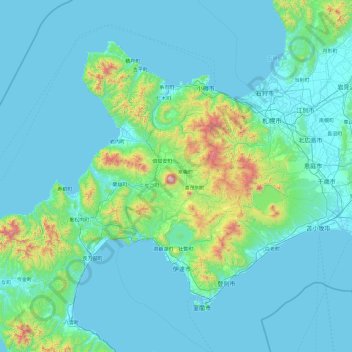
Name: Abuta County topographic map, elevation, terrain.
Average elevation: 147 m
Minimum elevation: -2 m
Maximum elevation: 1,825 m
Other topographic maps
Click on a map to view its topography, its elevation and its terrain.
Kanagawa Prefecture
Topographically, the prefecture consists of three distinct areas. The mountainous western region features the Tanzawa Mountain Range and the volcano Mount Hakone. The hilly eastern region is characterized by the Tama Hills and Miura Peninsula. The central region, which surrounds the Tama Hills and Miura…
Average elevation: 170 m
Okinawa Island
The Motobu Peninsula in the north has limestone layers and karst development. In the center and south is mainly a Ryukyu limestone layer and mudstone. The topography is flat, there are few hills over 100 m (328 ft) with very few rivers. The subtropical rains accelerate erosion so there are many drainages and…
Average elevation: 14 m
Hokkaido
Japan's coldest region, Hokkaido has relatively cool summers and icy/snowy winters. Most of the island falls in the humid continental climate zone with Köppen climate classification Dfb (hemiboreal) in most areas but Dfa (hot summer humid continental) in some inland lowlands. The average August temperature…
Average elevation: 98 m
Iki Island
Iki Island is slightly oval in shape, and measures approximately 17 kilometres (11 mi) from north-south and 14 kilometres (8.7 mi) from east-west. The highest elevation is Takenotsuji (岳ノ辻), a weakly curved peak with a highest elevation at 212.9 metres (698 ft) above sea level. The average height of the…
Average elevation: 21 m
Nagano
Nagano (長野市, Nagano-shi, pronounced [nagaꜜno ɕi]) is the capital and largest city of Nagano Prefecture, located in the Nagano Basin (Zenkoji Daira) in the central Chūbu region of Japan. Nagano is categorized as a core city of Japan. Nagano City is the highest prefectural capital in Japan, with an…
Average elevation: 828 m
Ebina
Ebina is located approximately 50 kilometers from central Tokyo and 20 kilometers from Yokohama. The city is roughly rectangular, 8.7 kilometers north-to-south by 6.15 kilometers east-to-west, with an elevation of 11 to 84 meters above sea level. It is in the middle of the Sagami Plain, part of western Kantō…
Average elevation: 33 m
Rikubetsu
Rikubetsu (陸別町, Rikubetsu-chō) is a town located in Tokachi Subprefecture, Hokkaido, Japan. It is located on the edge of the Tokachi Plain at an altitude of 207 metres (679 ft) above sea level.
Average elevation: 398 m
Koka
Kōka occupies the entire southern end of Shiga Prefecture, and is thus long east-to-west. At the eastern end of Kōka, the southern ridge of the Suzuka Mountains with one elevation of 1000 meters runs from northeast to southwest, forming the boundary with Mie Prefecture. The highest altitude point in Kōka is…
Average elevation: 300 m
Gokase
Gokase is located in the northwest Miyazaki Prefecture, in the center of the Kyushu Mountains, and borders Kumamoto Prefecture from the northern part of the town to the northwest, west, and southwest. The area is generally high in altitude, with even the hilly area in the north, the center of the town, being…
Average elevation: 766 m
Ōmachi
Due to its elevation, the city has a Köppen climate classification Dfa climate. Winters are cold and very snowy, while summers are very warm and wet. The average annual temperature in Ōmachi is 9.7 °C (49.5 °F). The average annual rainfall is 1,405.9 mm (55.35 in) with July as the wettest month. The…
Average elevation: 1,157 m
Tanegashima Island
The island is of volcanic origin; however, unlike neighboring Yakushima, it presents a flat appearance, with its highest elevation at only 282 metres (925 ft) above sea level. The island has a length of 57 kilometres (31 nmi) and a width ranging from 5 kilometres (2.7 nmi) to 10 kilometres (5.4 nmi). The…
Average elevation: 14 m
Nagato
Nagato is located in northwestern Yamaguchi. The north side faces the Sea of Japan, and the coastline facing the open sea is eroded terrain. On the other hand, there are coves such as Fukagawa Bay and Senzaki Bay, which are surrounded by the island of Ōmijima and the mainland, and Aburaya Bay, which is…
Average elevation: 71 m
Takeo
Takeo is located in the western part of Saga Prefecture. It is approximately 28 kilometers (17 mi) west of Saga City and approximately 30 kilometers (19 mi) east of Sasebo. Takeo has a complex topography including mountains, mountain basins and riverside plains. The population is concentrated in the western…
Average elevation: 103 m
Akusekijima
Japan > Kagoshima County > Toshima
The island is an andesite – dacite stratovolcano formed by two summit craters, Biroyama (ビロ山) 355.5 metres (1,166 ft) and Nakadake (中岳). 464 metres (1,522 ft). Mitake (御岳山) 584 metres (1,916 ft), the highest elevation on the island, is a lava dome. Lava flows in the northern portion of the…
Average elevation: 112 m
KIta Hiroshima
Kitahiroshima is in the Chūgoku Mountains of north-central Hiroshima, bordered by Shimane Prefecture to the north. Due to its location and elevation, it is a heavy snowfall region.
Average elevation: 424 m
Izenajima
The total area is 15.44 square kilometres (5.96 sq mi), and the peripheral sea coast line is 16 kilometres (9.9 mi). The island's topography features a series of mountains spanning from the northwest to the southeast of the island, with generally flat, arable land covering the remainder. The island has several…
Average elevation: 13 m
Tairajima
Japan > Kagoshima County > Toshima
Tairajima is located 32 kilometres (17 nmi) southwest of Nakanoshima, and is the second smallest inhabited islands in the archipelago. The island has an area of approximately 2.08 square kilometres (0.80 sq mi) with a length of about 1.5 kilometres (0.93 mi) and a width of 1.0 kilometre (0.62 mi). The highest…
Average elevation: 22 m
Yokoatejima
Japan > Kagoshima County > Toshima
The island is formed by two smaller stratovolcanoes - Higashimine (東峰) to the east, with a maximum elevation of 494.8 metres (1,623 ft) and Nishimine (西峰) to the west, with a maximum elevation of 259 metres (850 ft). The only known volcanic activity on either peak was towards the end of the Edo period,…
Average elevation: 47 m
Suwanosejima
Japan > Kagoshima County > Toshima
Suwanosejima is the second largest of the islands in the Tokara archipelago, and is located 21 kilometres (11 nmi) southwest from Nakanoshima. The highest elevation is Otake (御岳), with a height of 796 metres (2,612 ft) above sea level, which is the exposed cone of an active stratovolcano arising from the…
Average elevation: 106 m