
Central District topographic map
Interactive map
Click on the map to display elevation.
About this map
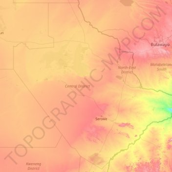
Name: Central District topographic map, elevation, terrain.
Location: Central District, Botswana (-24.07902 23.61542 -18.87902 28.81542)
Average elevation: 1,007 m
Minimum elevation: 546 m
Maximum elevation: 1,786 m
Other topographic maps
Click on a map to view its topography, its elevation and its terrain.
North-West District
The region has an average elevation of around 915 m (3,002 ft) above the mean sea level. The vegetation type is Savannah, with tall grasses, bushes and trees. The annual precipitation is around 650 mm (26 in), most of which is received during the summer season from November to May.
Average elevation: 979 m
Kweneng District
Kweneng is the only district without a foreign border. It borders Central District in northeast, Kgatleng District on the east, South-East District in southeast, Southern District in south, Kgalagadi District in the west, Ghanzi District in the north. The region is traversed by the northwesterly line of equal…
Average elevation: 1,083 m
Okavango Delta
Botswana > North-West District
The Okavango Delta (or Okavango Grassland; formerly spelled "Okovango" or "Okovanggo") in Botswana is a vast inland delta formed where the Okavango River reaches a tectonic trough at an altitude of 930–1,000 m in the central part of the endorheic basin of the Kalahari Desert.
Average elevation: 959 m
Chobe District
Kasane, Chobe National Park, Seboba Water Rapids, Pandamatenga Farms, Lesoma Memorial Monument, Kasane Hot Springs and Chobe River are the major tourist attractions in the district. Most part of Botswana has tableland slopes sliding from east to west. The region has an average elevation of around 915 m (3,002…
Average elevation: 981 m
Central District
Most part of Botswana has tableland slopes sliding from east to west. The region has an average elevation of around 915 m (3,002 ft) above the mean sea level. The vegetation type is Savannah, with tall grasses, bushes and trees. The annual precipitation is around 65 cm (26 in), most of which is received during…
Average elevation: 1,006 m