
San Cristóbal topographic map
Interactive map
Click on the map to display elevation.
About this map
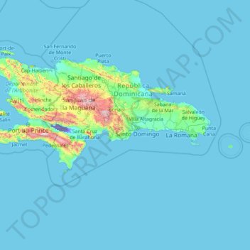
Name: San Cristóbal topographic map, elevation, terrain.
Location: San Cristóbal, Dominican Republic (15.92009 -72.80768 21.12009 -67.60768)
Average elevation: 83 m
Minimum elevation: -44 m
Maximum elevation: 2,839 m
Other topographic maps
Click on a map to view its topography, its elevation and its terrain.
Pedernales
Pedernales is located in a geomorphological region known as Procurrente de Barahona. The area of Pedernales has some of the most arid lands in the country. It is formed by successive marine terraces. The lowest part of these is on the edge of the coast, less than 100 m s. n. m. (meters above sea level). As one…
Average elevation: 273 m
Constanza
Dominican Republic > La Vega > Constanza
The town of Constanza is located at a height of 1220 meters (4000 ft) above sea level in the middle of the Cordillera Central (Central Range), the tallest mountain range in the island of Hispaniola and the entire Caribbean region. The annual average temperatures range from 41 °F (5 °C) to 68 °F (20 °C),…
Average elevation: 1,191 m
Río Yaque del Norte
Dominican Republic > Santiago > Puñal > Santiago de los Caballeros
Average elevation: 250 m
Moca
Dominican Republic > Espaillat
Moca has a total area of 339.21 km². The municipality sits on a volcanic coral reef with hills to the west and low mountains to the north; these mountains are part of the Cordillera Septentrional. The highest mountain in the municipality, and in the province, is El Mogote at (970 m). Moca is at an elevation…
Average elevation: 365 m
Santiago de los Caballeros
Santiago de los Caballeros (English: Saint James of the Knights), often shortened to Santiago, is the second-largest city in the Dominican Republic and the fourth-largest city in the Caribbean by population. It is the capital of Santiago Province and the largest major metropolis in the Cibao region of the…
Average elevation: 341 m