
Rohtang Pass topographic map
Interactive map
Click on the map to display elevation.
About this map
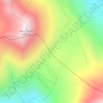
Name: Rohtang Pass topographic map, elevation, terrain.
Location: Rohtang Pass, Lahul, Lahul and Spiti, Himachal Pradesh, India (32.37095 77.24622 32.37105 77.24632)
Average elevation: 4,042 m
Minimum elevation: 3,484 m
Maximum elevation: 4,617 m
Other topographic maps
Click on a map to view its topography, its elevation and its terrain.
Shikari Devi Wildlife Sanctuary
India > Himachal Pradesh > Thunag > Sangalwara
Average elevation: 2,518 m
Lahaul and Spiti
The two valleys are quite different in character. Spiti is more barren and difficult to cross, with an average elevation of the valley floor of 4,270 m (14,010 ft). It is enclosed between lofty ranges, with the Spiti river rushing out of a gorge in the southeast to meet the Sutlej River. It is a typical…
Average elevation: 4,281 m
Kinnaur District
A mountainous area, ranging in altitude from 2,320 to 6,816 metres (7,612 to 22,362 ft), Kinnaur is one of the smallest districts in India by population. It is known for the Kinnaur Kailash, a mountain sacred to Hindus, close to the Chinese border.
Average elevation: 4,303 m
Bir
India > Himachal Pradesh > Bir
The paragliding launch site is in the meadow at Billing (14 km north of Bir), at an elevation of 2400 metres, while the landing site and most tourist accommodations are in the village of Chowgan (also spelled Chaugan), on the southern edge of Bir.
Average elevation: 1,616 m