
Kabal topographic map
Interactive map
Click on the map to display elevation.
About this map
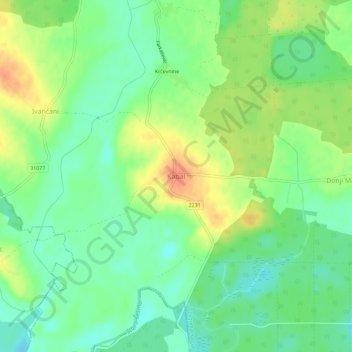
Name: Kabal topographic map, elevation, terrain.
Location: Kabal, Zagreb County, 10344, Croatia (45.83796 16.61958 45.87796 16.65958)
Average elevation: 115 m
Minimum elevation: 95 m
Maximum elevation: 142 m
Other topographic maps
Click on a map to view its topography, its elevation and its terrain.
Jastrebarsko
Jastrebarsko is located in the Prigorje region of Central Croatia, built around the Reka Creek (Croatian: Potok Reka; reka is Kajkavian dialect word for river). On the west, Jastrebarsko is bordered by the Žumberak Mountain (Croatian: Žumberačka gora), a mountain range spreading through southeast Slovenia…
Average elevation: 145 m