
Make a donation
Gear up for your next adventure:
As an Amazon Associate, this site earns from qualifying purchases at no extra cost to you.
Qarokul (Karakul) topographic map
Click on the map to display elevation.
Make a donation
Gear up for your next adventure:
As an Amazon Associate, this site earns from qualifying purchases at no extra cost to you.
About this map
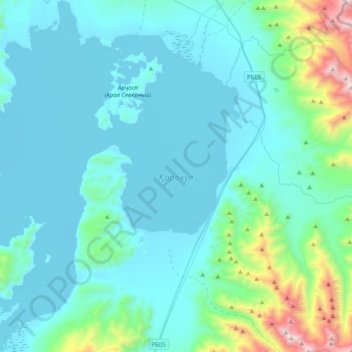
Name: Qarokul (Karakul) topographic map, elevation, terrain.
Average elevation: 4,135 m
Minimum elevation: 3,911 m
Maximum elevation: 5,696 m
Make a donation
Gear up for your next adventure:
As an Amazon Associate, this site earns from qualifying purchases at no extra cost to you.
Other topographic maps
Click on a map to view its topography, its elevation and its terrain.
Ishkoshim
Tajikistan > Gorno-Badakhshan Autonomous Region > Ishkoshim District
Average elevation: 2,957 m
Бомакчашма
Tajikistan > Gorno-Badakhshan Autonomous Region > Rushon District > Pastkhuf
Average elevation: 2,220 m
Make a donation
Gear up for your next adventure:
As an Amazon Associate, this site earns from qualifying purchases at no extra cost to you.
Navobod
Tajikistan > Gorno-Badakhshan Autonomous Region > Shughnon District
Average elevation: 2,946 m
Qal'ai Khumb
Tajikistan > Gorno-Badakhshan Autonomous Region > Darvoz District
Average elevation: 1,891 m
Independence Peak
Tajikistan > Gorno-Badakhshan Autonomous Region > Rushon District
Average elevation: 6,373 m
Make a donation
Gear up for your next adventure:
As an Amazon Associate, this site earns from qualifying purchases at no extra cost to you.
Ak-Baital
Tajikistan > Gorno-Badakhshan Autonomous Region > Murghob District
Average elevation: 4,759 m
Sumgad-Langar
Tajikistan > Gorno-Badakhshan Autonomous Region > Vanj District
Average elevation: 4,603 m
Make a donation
Gear up for your next adventure:
As an Amazon Associate, this site earns from qualifying purchases at no extra cost to you.