
Setesdal topographic map
Interactive map
Click on the map to display elevation.
About this map
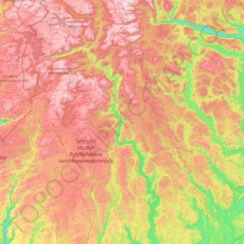
Name: Setesdal topographic map, elevation, terrain.
Location: Setesdal, 4741, Norway (58.59056 7.32031 59.52712 7.83805)
Average elevation: 754 m
Minimum elevation: 46 m
Maximum elevation: 1,583 m
Other topographic maps
Click on a map to view its topography, its elevation and its terrain.
Norway
Norway's topography is defined by its rugged and varied terrain, shaped by ancient geological processes and glacial activity. Dominating the landscape are the Scandinavian Mountains, which run through the country and include peaks like Galdhøpiggen, the highest in Northern Europe at 2,469 meters (8,100 feet).…
Average elevation: 143 m
Trondheim
Norway > Trøndelag > Trondheim
Trondheim is situated where the River Nidelva meets Trondheim Fjord with an excellent harbour and sheltered condition. The river used to be deep enough for most boats in the Middle Ages. An avalanche of mud and stones made it less navigable and partly ruined the harbour in the mid-17th century. The…
Average elevation: 118 m
Norway
At 385,207 square kilometres (148,729 sq mi) (including Svalbard and Jan Mayen; 323,808 square kilometres (125,023 sq mi) without), much of the country is dominated by mountainous or high terrain, with a great variety of natural features caused by prehistoric glaciers and varied topography. The most noticeable…
Average elevation: 143 m
Tromsø
Outside the city, large areas in the municipality are at some altitude and above the treeline with an alpine tundra climate (ET). The islands to the west at the outer seabord are milder in winter like Måsvik, making this part of the municipality a subpolar oceanic climate (Cfc) zone. The average date for…
Average elevation: 193 m
Scandinavian Mountains
The mountain chain's highest summits are mostly concentrated in an area (of mean altitude of over 1,000 m) between Stavanger and Trondheim in South Norway, with numerous peaks over 1,300 m and some peaks over 2,000 m. Around Trondheim Fjord, peaks decrease in altitude to about 400–500 m rising again to…
Average elevation: 2,050 m
Stavanger
The municipality of Stavanger is located in a coastal landscape, bordering the sea to the west and Boknafjorden in the northeast. The Byfjorden and Gandsfjorden run along the east side of the city. It is part of the Low-Jæren, a flat area of land consisting mostly of marsh, sand, and stone aur, that ranges…
Average elevation: 44 m
Reine
Allers, the largest weekly magazine in Norway, selected Reine as the most beautiful village in Norway in the late 1970s. A photograph over Reine from the mountain Reinebringen (altitude 448 metres (1,470 ft)) has been used for the front page of several tourist brochures and books. In 1999, the painter Ingo…
Average elevation: 58 m
Finnmark
The county's interior parts are part of the great Finnmarksvidda plateau, with an elevation of 300 to 400 m (980 to 1,310 ft), with multiple lakes and river valleys. The plateau is famous for its tens of thousands of reindeer owned by the Sámi, and swarms of mosquitoes in midsummer. Finnmarksvidda makes up…
Average elevation: 227 m
Troll tongue
The hike from the parking area to Trolltunga and back again is a 27-kilometre (17 mi) round-trip distance with a 1,100-metre (3,600 ft) gain in elevation, and it takes approximately 10–12 hours, including breaks.
Average elevation: 1,091 m
Galdhøpiggen
At Juvasshytta there is an alpine ski resort with lift on a glacier, reaching an elevation of 2,200 metres (7,200 ft) above sea level, the highest in Scandinavia. It is called Galdhøpiggen Summer Ski Centre and is open from June and all the summer when the road is open.
Average elevation: 2,105 m
Hardangervidda National Park
The plateau is the largest peneplain (eroded plain) in Europe, covering an area of about 6,500 km2 (2,500 sq mi) at an average elevation of 1,100 metres (3,600 ft). The highest point on the plateau is at the top of the Hardangerjøkulen glacier, which reaches a height of 1,863 m (6,112 ft).
Average elevation: 1,183 m