Geolocate

Svalbard topographic map

Interactive map

Click on the map to display elevation.

About this map

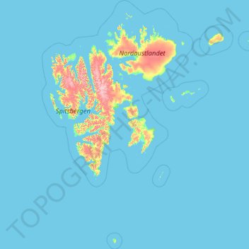
Name: Svalbard topographic map, elevation, terrain.

Location: Svalbard, 9170, Norway (74.13545 9.42089 81.02802 34.68891)

Average elevation: 46 m

Minimum elevation: -2 m

Maximum elevation: 1,650 m

Other topographic maps

Click on a map to view its topography, its elevation and its terrain.

Norway

Norway

Little has been found dating from the early Iron Age (the last 500 years BC). The dead were cremated, and their graves contain few burial goods. During the first four centuries AD, the people of Norway were in contact with Roman-occupied Gaul. About 70 Roman bronze cauldrons, often used as burial urns, have…

Average elevation: 143 m

Scandinavian Mountains

Norway > Innlandet

The mountain chain's highest summits are mostly concentrated in an area (of mean altitude of over 1,000 m) between Stavanger and Trondheim in South Norway, with numerous peaks over 1,300 m and some peaks over 2,000 m. Around Trondheim Fjord, peaks decrease in altitude to about 400–500 m rising again to…

Average elevation: 2,050 m

Tromsø

Norway > Troms og Finnmark

Outside the city, large areas in the municipality are at some altitude and above the treeline with an alpine tundra climate (ET). The islands to the west at the outer seabord are milder in winter like Måsvik, making this part of the municipality a subpolar oceanic climate (Cfc) zone. The average date for…

Average elevation: 193 m

Stavanger

Norway > Rogaland

The municipality of Stavanger is located in a coastal landscape, bordering the sea to the west and Boknafjorden in the northeast. The Byfjorden and Gandsfjorden run along the east side of the city. It is part of the Low-Jæren, a flat area of land consisting mostly of marsh, sand, and stone aur, that ranges…

Average elevation: 44 m

Bergen

Norway > Vestland

Average elevation: 125 m

Bersagel

Norway > Rogaland

Average elevation: 67 m

Oslo

Norway > Oslo

Average elevation: 186 m

Vikersund

Norway > Buskerud

Average elevation: 217 m

Jan Mayen

Norway > Jan Mayen

Jan Mayen consists of two geographically distinct parts. Nord-Jan has a round shape and is dominated by the 2,277 m (7,470 ft) high Beerenberg volcano with its large ice cap (114.2 km2 or 44 sq mi), which can be divided into twenty individual outlet glaciers. The largest of those is Sørbreen, with an area of…

Average elevation: 95 m

Bouvet Island

Norway

Average elevation: 189 m

Fauske - Fuossko

Norway > Nordland

Average elevation: 98 m

Lofoten

Norway > Nordland

Average elevation: 232 m

Trondheim

Norway > Trøndelag > Trondheim

Trondheim is situated where the River Nidelva meets Trondheim Fjord with an excellent harbour and sheltered condition. The river used to be deep enough for most boats in the Middle Ages. An avalanche of mud and stones made it less navigable and partly ruined the harbour in the mid-17th century. The…

Average elevation: 118 m

Moss

Norway > Østfold

Average elevation: 42 m

Fitja

Norway > Vestland > Etne

Average elevation: 179 m

Randaberg

Norway > Rogaland

Average elevation: 10 m

Gullholmen

Norway > Vestland

Average elevation: 1 m

Gautestad

Norway > Agder

Average elevation: 523 m

Sotra

Norway > Vestland

Average elevation: 37 m

Gamvik

Norway > Finnmark

Average elevation: 116 m

Engelsviken

Norway > Østfold > Fredrikstad

Average elevation: 12 m

Vøringsfossen

Norway > Vestland

Average elevation: 772 m

Tangen

Norway > Vestland > Bergen

Average elevation: 15 m

Karmøy

Norway > Rogaland

Average elevation: 16 m

Tønsberg

Norway > Vestfold

Average elevation: 38 m

Bear Island

Norway

Average elevation: 35 m

Vevang

Norway > Møre og Romsdal > Groravika

Average elevation: 6 m

Averøy

Norway > Møre og Romsdal

Average elevation: 27 m

Nodeland

Norway > Agder

Average elevation: 94 m

Skaret

Norway > Vestland

Average elevation: 1,168 m

Hol

Norway > Buskerud

Average elevation: 1,204 m

Skånevik

Norway > Vestland

Average elevation: 145 m

Hesteberget

Norway > Buskerud

Average elevation: 1,345 m

Besseggen

Norway > Innlandet

Average elevation: 1,312 m

Åndalsnes

Norway > Møre og Romsdal

Average elevation: 328 m

Uvdal alpinsenter

Norway > Buskerud

Average elevation: 893 m

Pulpit Rock

Norway > Rogaland

Average elevation: 310 m

Åsnes

Norway > Innlandet

Average elevation: 349 m

Nesna

Norway > Nordland

Average elevation: 138 m

Varhaug

Norway > Rogaland

Average elevation: 43 m

Vinje

Norway > Møre og Romsdal > Geiranger

Average elevation: 562 m

Larvik

Norway > Vestfold og Telemark

Average elevation: 45 m

Trollstigen

Norway > Innlandet

Average elevation: 459 m

Mesnlia

Norway > Innlandet

Average elevation: 627 m

Skei

Norway > Møre og Romsdal

Average elevation: 139 m

Sjernarøy

Norway > Rogaland > Stavanger

Average elevation: 9 m

Oppdal

Norway > Trøndelag

Average elevation: 1,085 m

Titran

Norway > Trøndelag

Average elevation: 2 m

Florida

Norway > Agder > Farsund

Average elevation: 19 m

Valle

Norway > Agder

Average elevation: 914 m