
Malaysia topographic map
Interactive map
Click on the map to display elevation.
About this map
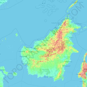
Name: Malaysia topographic map, elevation, terrain.
Location: Malaysia (-5.10762 105.34719 9.89238 120.34719)
Average elevation: 80 m
Minimum elevation: -3 m
Maximum elevation: 3,432 m
Other topographic maps
Click on a map to view its topography, its elevation and its terrain.
Negeri Sembilan
Topographically, Negeri Sembilan consists of two plains divided by a mountainous spine in the middle. This region is well drained by various rivers on both sides. The Titiwangsa Mountains, the southernmost extension of the Tenasserim Hills and the wider Indo-Malayan Cordillera, spans approximately 92 km (57.1…
Average elevation: 119 m
Sarawak
Sarawak can be divided into two geological zones: the Sunda Shield, which extends southwest from the Batang Lupar River (near Sri Aman) and forms the southern tip of Sarawak, and the geosyncline region, which extends northeast to the Batang Lupar River, forming the central and northern regions of Sarawak. The…
Average elevation: 228 m
Sabah
The jungles of Sabah host a diverse array of plant and animal species. Most of Sabah's biodiversity is located in the forest reserve areas, which formed half of its total landmass of 7.34 million hectares. Its forest reserve are part of the 20 million hectares equatorial rainforests demarcated under the "Heart…
Average elevation: 115 m
Terengganu
Terengganu is situated in eastern Peninsular Malaysia, and is bordered to the northwest by Kelantan, to the southwest by Pahang, and to the east by the South China Sea. The state has a total area of 13,035 km2 (5,033 sq mi). Its topographical profile ranges from relatively level on the east coast and gradually…
Average elevation: 127 m
Kuala Lumpur
Located in the centre of Selangor state, Kuala Lumpur was a territory of Selangor State Government. In 1974, Kuala Lumpur was split off from Selangor to form the first Federal Territory governed directly by the Malaysian federal government. Its location in the most developed state on the west coast of…
Average elevation: 80 m
Penang
Penang Island is irregularly shaped, with a hilly and mostly forested interior; its coastal plains are narrow, the most extensive of which is at the northeastern cape. With a height of 833 m (2,733 ft), Penang Hill, at the centre of the island, is the tallest point within Penang. From a small settlement at the…
Average elevation: 18 m
Selangor
Topographically wise, Selangor is relatively level near the coast and gradually become more hilly and mountainous towards the east. The hill and mountain, surrounding the eastern and central portion of the state effectively forming a valley and a drainage basin of the Klang River, known as the Klang Valley,…
Average elevation: 98 m
Batu Metropolitan Park
Malaysia > Kuala Lumpur > Kuala Lumpur > Kampung Sri Batu
Average elevation: 47 m
Malacca
The state of Malacca covers an area of 1,664 km2 (642 sq mi). It sits upon the southwestern coast of the Malay Peninsula opposite Sumatra, with the state of Negeri Sembilan to the north and west and Johor to the east. Malacca is situated roughly two-thirds of the way down the west coast, 148 km (92 mi) south…
Average elevation: 26 m
Padang SMK Jengka Pusat
Malaysia > Pahang > Bandar Tun Abdul Razak (Bandar Jengka)
Average elevation: 75 m
Perak
In 1959, a British artillery officer stationed at an inland army base during the Malayan Emergency discovered the Tambun rock art, identified by archaeologists as the largest rock art site in the Malay Peninsula. Most of the paintings are located high above the cave floor, at an elevation of 6–10 metres…
Average elevation: 251 m
Penang
Penang Island is irregularly shaped, with a hilly and mostly forested interior. The island's coastal plains are narrow, with the most extensive plain located at the northeastern cape. George Town, which started off as a small settlement at the northeastern tip of the island, has expanded over the centuries to…
Average elevation: 18 m
Semungkis River
Malaysia > Selangor > Kajang Municipal Council > Batu 14 Hulu Langat
Average elevation: 186 m
Kuala Lumpur
Located in the centre of Selangor state, Kuala Lumpur was a territory of Selangor State Government. In 1974, Kuala Lumpur was split off from Selangor to form the first Federal Territory governed directly by the Malaysian federal government. Its location in the most developed state on the west coast of…
Average elevation: 87 m
Selangor
Topographically wise, Selangor is relatively level near the coast and gradually become more hilly and mountainous towards the east. The hill and mountain, surrounding the eastern and central portion of the state effectively forming a valley and a drainage basin of the Klang River, known as the Klang Valley,…
Average elevation: 98 m
Sungai Ruan
Covering a total area of 9.7 square km at an average elevation of 227 meters above sea level, the village is surrounded by hills, forest and plantations with a population of about 6,000 people.
Average elevation: 142 m
Sabah
The jungles of Sabah host a diverse array of plant and animal species. Most of Sabah's biodiversity is located in the forest reserve areas, which formed half of its total landmass of 7.34 million hectares. Its forest reserve are part of the 20 million hectares equatorial rainforests demarcated under the "Heart…
Average elevation: 115 m
Sibu
Malaysia > Sarawak > Sibu > Sibu
Sibu is located near the Rajang delta at the confluence of Rajang and Igan rivers. Peat swamp forests and alluvial plains are particularly prevalent in the Sibu Division. Sibu is located on a deep peat soil, which has caused problems in infrastructure development because buildings and roads slowly sink into…
Average elevation: 9 m
Malacca
The state of Malacca covers an area of 1,775 km2 (685 sq mi). It is located on the southwestern coast of the Malay Peninsula opposite Sumatra, with the state of Negeri Sembilan to the north and west and Johor to the east. Malacca is situated roughly two-thirds of the way down the west coast, 149 km (93 mi)…
Average elevation: 26 m
Sungai Tekali
Malaysia > Selangor > Kajang Municipal Council > Batu 14 Hulu Langat
Average elevation: 79 m