
Make a donation
Gear up for your next adventure:
As an Amazon Associate, this site earns from qualifying purchases at no extra cost to you.
Penang topographic map
Click on the map to display elevation.
Make a donation
Gear up for your next adventure:
As an Amazon Associate, this site earns from qualifying purchases at no extra cost to you.
Penang
Penang Island is irregularly shaped, with a hilly and mostly forested interior; its coastal plains are narrow, the most extensive of which is at the northeastern cape. With a height of 833 m (2,733 ft), Penang Hill, at the centre of the island, is the tallest point within Penang. From a small settlement at the northeastern tip of Penang Island, George Town has expanded over the centuries, particularly in the northwestern, western and southern directions, eventually linking up with Bayan Lepas at the island's southeast and urbanising the entire eastern coast of the island. Meanwhile, the topography of Seberang Perai is mostly flat, save for a few hills such as Bukit Mertajam.
Make a donation
Gear up for your next adventure:
As an Amazon Associate, this site earns from qualifying purchases at no extra cost to you.
About this map
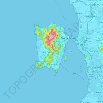
Name: Penang topographic map, elevation, terrain.
Location: Penang, Malaysia (5.12200 100.17498 5.58568 100.55031)
Average elevation: 18 m
Minimum elevation: -3 m
Maximum elevation: 798 m
Make a donation
Gear up for your next adventure:
As an Amazon Associate, this site earns from qualifying purchases at no extra cost to you.
Other topographic maps
Click on a map to view its topography, its elevation and its terrain.
Kuala Lumpur
Located in the centre of Selangor state, Kuala Lumpur was a territory of Selangor State Government. In 1974, Kuala Lumpur was split off from Selangor to form the first Federal Territory governed directly by the Malaysian federal government. Its location in the most developed state on the west coast of…
Average elevation: 127 m
Make a donation
Gear up for your next adventure:
As an Amazon Associate, this site earns from qualifying purchases at no extra cost to you.
Cameron Highlands
Surveyed by the government geologist and explorer William Cameron in 1885, the outpost consists of three mukims (subdistricts), namely Ringlet, Tanah Rata and Ulu Telom. Its eight settlements are Ringlet, Tanah Rata (the administrative centre), Brinchang, the Bertam Valley, Kea Farm, Tringkap, Kampung Kuala…
Average elevation: 1,400 m
Mount Kinabalu
Mount Kinabalu (Malay: Gunung Kinabalu, Dusun: Gayo Ngaran or Nulu Nabalu) is the highest mountain in Borneo and Malaysia. With an elevation of 13,435 feet (4,095 m), it is third-highest peak of an island on Earth, and 20th most prominent mountain in the world by topographic prominence. The mountain is located…
Average elevation: 3,567 m
Make a donation
Gear up for your next adventure:
As an Amazon Associate, this site earns from qualifying purchases at no extra cost to you.
Kampung Janda Baik
Before Janda Baik was founded in 1930, the area was primarily inhabited by Orang Asli tribes. The village was founded when some residents moved from Bentong to an area with a higher elevation due to the 1926 floods that affected Bentong and other low elevation areas. The earliest founders for this village are…
Average elevation: 467 m
Make a donation
Gear up for your next adventure:
As an Amazon Associate, this site earns from qualifying purchases at no extra cost to you.
Make a donation
Gear up for your next adventure:
As an Amazon Associate, this site earns from qualifying purchases at no extra cost to you.
Sibu
Sibu is located near the Rajang delta at the confluence of Rajang and Igan rivers. Peat swamp forests and alluvial plains are particularly prevalent in the Sibu Division. Sibu is located on a deep peat soil, which has caused problems in infrastructure development because buildings and roads slowly sink into…
Average elevation: 10 m
Make a donation
Gear up for your next adventure:
As an Amazon Associate, this site earns from qualifying purchases at no extra cost to you.
Make a donation
Gear up for your next adventure:
As an Amazon Associate, this site earns from qualifying purchases at no extra cost to you.
Make a donation
Gear up for your next adventure:
As an Amazon Associate, this site earns from qualifying purchases at no extra cost to you.
Penang Island
Penang Island is irregularly shaped, with a hilly and mostly forested interior; its coastal plains are narrow, the most extensive of which is at the northeastern cape. With a height of 833 m (2,733 ft), Penang Hill, at the centre of the island, is the tallest point within Penang. From a small settlement at the…
Average elevation: 117 m
Make a donation
Gear up for your next adventure:
As an Amazon Associate, this site earns from qualifying purchases at no extra cost to you.
Make a donation
Gear up for your next adventure:
As an Amazon Associate, this site earns from qualifying purchases at no extra cost to you.
Make a donation
Gear up for your next adventure:
As an Amazon Associate, this site earns from qualifying purchases at no extra cost to you.
Make a donation
Gear up for your next adventure:
As an Amazon Associate, this site earns from qualifying purchases at no extra cost to you.
Make a donation
Gear up for your next adventure:
As an Amazon Associate, this site earns from qualifying purchases at no extra cost to you.
Make a donation
Gear up for your next adventure:
As an Amazon Associate, this site earns from qualifying purchases at no extra cost to you.
Make a donation
Gear up for your next adventure:
As an Amazon Associate, this site earns from qualifying purchases at no extra cost to you.
Make a donation
Gear up for your next adventure:
As an Amazon Associate, this site earns from qualifying purchases at no extra cost to you.
Pahang
The highest peak, Mount Tahan, reaches 2,187 m (7,175 ft) in elevation, which is also the highest point in the Peninsular Malaysia. The climate is temperate enough to have distinct temperature variations year round, and much of the highlands are covered with tropical rainforest. Pahang is home to Malaysia's…
Average elevation: 90 m
Make a donation
Gear up for your next adventure:
As an Amazon Associate, this site earns from qualifying purchases at no extra cost to you.
Kuala Terengganu
Malaysia > Terengganu > Kuala Terengganu
As a part of Terengganu, Kuala Terengganu has a tropical rainforest climate under the Köppen climate classification (Af) with constant temperature and high humidity. The amount of rainfall varies according to the monsoon season. It is generally fairly hot and humid all year round, averaging from 28 °C to 30…
Average elevation: 9 m
Make a donation
Gear up for your next adventure:
As an Amazon Associate, this site earns from qualifying purchases at no extra cost to you.
Make a donation
Gear up for your next adventure:
As an Amazon Associate, this site earns from qualifying purchases at no extra cost to you.
Make a donation
Gear up for your next adventure:
As an Amazon Associate, this site earns from qualifying purchases at no extra cost to you.
Make a donation
Gear up for your next adventure:
As an Amazon Associate, this site earns from qualifying purchases at no extra cost to you.
Seri Iskandar
Seri Iskandar (Jawi: سري إسكندر, Chinese: 斯里依斯干达) is a major town within the Perak Tengah District in the state of Perak, Malaysia. It is situated about 40 kilometers southwest of the city of Ipoh, the state capital. The town is at an average elevation of 29 meters above the sea level. The…
Average elevation: 29 m
Make a donation
Gear up for your next adventure:
As an Amazon Associate, this site earns from qualifying purchases at no extra cost to you.
Make a donation
Gear up for your next adventure:
As an Amazon Associate, this site earns from qualifying purchases at no extra cost to you.
Tioman Island
Local mythology claims that the island is the embodiment of the mighty dragon Sri Gumom. The dragon was on his way to visit his sister Gunung Linga (Lingin Peak). Still, the great Sri Rama forbade the meeting, and Sri Gumom was turned into a stone and fell into the deep sea where he now remains, frozen in…
Average elevation: 104 m
Make a donation
Gear up for your next adventure:
As an Amazon Associate, this site earns from qualifying purchases at no extra cost to you.
Make a donation
Gear up for your next adventure:
As an Amazon Associate, this site earns from qualifying purchases at no extra cost to you.
Make a donation
Gear up for your next adventure:
As an Amazon Associate, this site earns from qualifying purchases at no extra cost to you.