Geolocate

Terengganu topographic map

Interactive map

Click on the map to display elevation.

Terengganu

Terengganu is situated in eastern Peninsular Malaysia, and is bordered to the northwest by Kelantan, to the southwest by Pahang, and to the east by the South China Sea. The state has a total area of 13,035 km2 (5,033 sq mi). Its topographical profile ranges from relatively level on the east coast and gradually becomes more hilly and mountainous towards the west, as its western borders are delineated by the Pantai Timur Range, with the highest point being Mount Lawit. The range acts as the main watershed for the state's riverine systems, as it is also home to Kenyir Lake, which is the source of the Terengganu River, is the largest man-made lake in Malaysia and serves as the state's major reservoir. Several outlying islands, including the Perhentians, Kapas and Redang, are also a part of the state.

Wikipedia (CC-BY-SA 3.0)

About this map

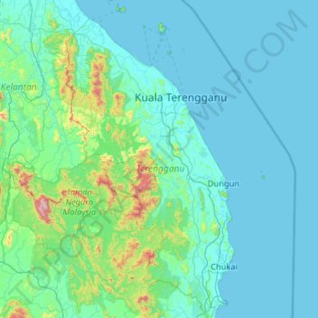
Name: Terengganu topographic map, elevation, terrain.

Location: Terengganu, Malaysia (3.88130 102.37847 5.96413 103.69061)

Average elevation: 127 m

Minimum elevation: -1 m

Maximum elevation: 2,125 m

Other topographic maps

Click on a map to view its topography, its elevation and its terrain.

Puchong

Malaysia > Selangor > Subang Jaya City Council

Average elevation: 38 m

Penang Island

Malaysia > Penang Island

Penang Island is irregularly shaped, with a hilly and mostly forested interior; its coastal plains are narrow, the most extensive of which is at the northeastern cape. With a height of 833 m (2,733 ft), Penang Hill, at the centre of the island, is the tallest point within Penang. From a small settlement at the…

Average elevation: 117 m

Kuching

Malaysia > Sarawak > Kuching

Average elevation: 17 m

Permatang Manggis

Malaysia > Penang > Tasek Gelugor

Average elevation: 7 m

Seri Iskandar

Malaysia > Perak

Seri Iskandar (Jawi: سري إسكندر, Chinese: 斯里依斯干达) is a major town within the Perak Tengah District in the state of Perak, Malaysia. It is situated about 40 kilometers southwest of the city of Ipoh, the state capital. The town is at an average elevation of 29 meters above the sea level. The…

Average elevation: 29 m

Kota Kinabalu

Malaysia > Sabah

Average elevation: 86 m

Miri

Malaysia > Sarawak > Miri

Average elevation: 9 m

Jeram Kedah

Malaysia > Negeri Sembilan

Average elevation: 157 m

Kuala Lumpur

Malaysia > Kuala Lumpur

Located in the centre of Selangor state, Kuala Lumpur was a territory of Selangor State Government. In 1974, Kuala Lumpur was split off from Selangor to form the first Federal Territory governed directly by the Malaysian federal government. Its location in the most developed state on the west coast of…

Average elevation: 127 m

Gunung Ayer Hangat

Malaysia > Perak > Ipoh

Average elevation: 128 m

Teluk Panglima Garang

Malaysia > Selangor

Average elevation: 5 m

Bintulu

Malaysia > Sarawak > Bintulu

Average elevation: 18 m

Cameron Highlands

Malaysia > Pahang

Surveyed by the government geologist and explorer William Cameron in 1885, the outpost consists of three mukims (subdistricts), namely Ringlet, Tanah Rata and Ulu Telom. Its eight settlements are Ringlet, Tanah Rata (the administrative centre), Brinchang, the Bertam Valley, Kea Farm, Tringkap, Kampung Kuala…

Average elevation: 1,400 m

Johor Bahru

Malaysia > Johor

Average elevation: 23 m

Kampung Alur Tuman

Malaysia > Terengganu

Average elevation: 11 m

Kampung Gong Balai

Malaysia > Terengganu

Average elevation: 3 m

Gunung Datok

Malaysia > Perak > Ipoh

Average elevation: 141 m

Bukit Puchong

Malaysia > Pahang

Average elevation: 50 m

Kampung Bukit Sarang Ayam

Malaysia > Kedah

Average elevation: 24 m

Johor Bahru

Malaysia > Johor

Average elevation: 23 m

Puncak Alam

Malaysia > Selangor > Puncak Alam

Average elevation: 30 m

Genting Highlands

Malaysia > Pahang

Genting Highlands is a hill station and a city located on the peak of Mount Ulu Kali in the Titiwangsa Mountains, central Peninsular Malaysia, at 1800 metres elevation. It is the second seat of Bentong District after Bentong. Located in the state of Pahang. It was established in 1965 by the late Malaysian…

Average elevation: 1,141 m

Subang Jaya

Malaysia > Selangor > Subang Jaya

Average elevation: 35 m

Kampung Ulu Rening

Malaysia > Selangor

Average elevation: 113 m

Bukit Takar

Malaysia > Terengganu > Kemaman District > Chukai

Average elevation: 13 m

Kampung Podam

Malaysia > Sarawak > Bau

Average elevation: 73 m

Istana Alam Shah

Malaysia > Selangor > Klang City

Average elevation: 9 m

Kampung Chempaka

Malaysia > Pahang

Average elevation: 61 m

Sinurai

Malaysia > Sabah > Ranau

Average elevation: 128 m

Commonwealth Hill

Malaysia > Kuala Lumpur

Average elevation: 50 m

Klang

Malaysia > Selangor > Klang

Average elevation: 13 m

Ipoh

Malaysia > Perak > Majlis Bandaraya Ipoh

Average elevation: 205 m

Batu Pahat

Malaysia > Johor

Average elevation: 10 m

Kangar

Malaysia > Perlis

Average elevation: 28 m

Seremban

Malaysia > Negeri Sembilan

Average elevation: 168 m

Sarawak River

Malaysia > Sarawak > Kuching

Average elevation: 6 m

Bukit Besi

Malaysia > Johor

Average elevation: 9 m

Kuala Pahang

Malaysia > Pahang

Average elevation: 2 m

Cyberjaya

Malaysia > Selangor > Cyberjaya

Average elevation: 24 m

Sibu

Malaysia > Sarawak > Sibu

Sibu is located near the Rajang delta at the confluence of Rajang and Igan rivers. Peat swamp forests and alluvial plains are particularly prevalent in the Sibu Division. Sibu is located on a deep peat soil, which has caused problems in infrastructure development because buildings and roads slowly sink into…

Average elevation: 10 m

Pahang

Malaysia > Pahang

The highest peak, Mount Tahan, reaches 2,187 m (7,175 ft) in elevation, which is also the highest point in the Peninsular Malaysia. The climate is temperate enough to have distinct temperature variations year round, and much of the highlands are covered with tropical rainforest. Pahang is home to Malaysia's…

Average elevation: 90 m

Taman Aman Park

Malaysia > Selangor > Banting

Average elevation: 4 m

Kampung Tanjung Angsa

Malaysia > Terengganu

Average elevation: 6 m

Kota Kinabalu

Malaysia > Sabah

Average elevation: 86 m

Padang Sanai

Malaysia > Kedah

Average elevation: 48 m

Ladang Kulai Young

Malaysia > Johor > Kulai

Average elevation: 82 m

FELDA Chiku

Malaysia > Kelantan

Average elevation: 106 m

Kampong Tulang

Malaysia > Sarawak > Miri

Average elevation: 3 m

Pokok Machang

Malaysia > Penang > Tasek Gelugor

Average elevation: 6 m

Kampung Biong

Malaysia > Perak

Average elevation: 84 m

Kampung Bayayat

Malaysia > Sabah > Kota Belud

Average elevation: 214 m

Gua Musang

Malaysia > Kelantan

Average elevation: 144 m

Kundasang

Malaysia > Sabah > Ranau

Average elevation: 1,279 m

Kenyir Dam

Malaysia > Terengganu

Average elevation: 215 m

Tasik Aman

Malaysia > Selangor > Petaling Jaya

Average elevation: 42 m

Dala

Malaysia > Perak

Average elevation: 150 m

Kampung Paloh

Malaysia > Kelantan

Average elevation: 21 m

Brinchang

Malaysia > Pahang

Brinchang (also spelt Berincang) is a town and hill resort located at an altitude of 1,540 metres (5,050 ft) in Cameron Highlands in the state of Pahang, Malaysia. The town's name is derived from nearby Gunung Brinchang, which is the second highest point in Cameron Highlands.

Average elevation: 1,524 m

FELDA Lepar Utara 2 & 4

Malaysia > Pahang

Average elevation: 134 m

Air Kuning Selatan

Malaysia > Negeri Sembilan

Average elevation: 61 m

Kampung Raja

Malaysia > Pahang

Average elevation: 39 m

Gunung Irau

Malaysia > Perak

Average elevation: 1,709 m

Semenyih

Malaysia > Selangor > Kajang Municipal Council

Average elevation: 62 m

Tawar

Malaysia > Kedah

Average elevation: 45 m

Mantin

Malaysia > Negeri Sembilan

Average elevation: 111 m

Malacca City

Malaysia > Malacca

Average elevation: 12 m

Sapi Rock

Malaysia > Sabah > Sandakan District

Average elevation: 36 m

Felda Bersia

Malaysia > Perak

Average elevation: 169 m

Bukit Batu Sawa

Malaysia > Negeri Sembilan

Average elevation: 206 m

Kampung Putra Jaya

Malaysia > Sabah > Kunak

Average elevation: 13 m

Chengkau

Malaysia > Negeri Sembilan

Average elevation: 47 m

Sungai Chereh

Malaysia > Pahang

Average elevation: 87 m

Kampung Serkat

Malaysia > Johor > Serkat

Average elevation: 3 m

Pokok Jenerih

Malaysia > Penang > Kubang Menerong

Average elevation: 7 m

Taman Seri Belida

Malaysia > Kedah > Alor Setar

Average elevation: 4 m

Sungai Semantut

Malaysia > Pahang > Bentong

Average elevation: 174 m

Mount Kinabalu

Malaysia > Sabah > Ranau

Mount Kinabalu (Malay: Gunung Kinabalu, Dusun: Gayo Ngaran or Nulu Nabalu) is the highest mountain in Borneo and Malaysia. With an elevation of 13,435 feet (4,095 m), it is third-highest peak of an island on Earth, and 20th most prominent mountain in the world by topographic prominence. The mountain is located…

Average elevation: 3,567 m

Kampung Sungai Itek

Malaysia > Perak > Gopeng

Average elevation: 114 m

Simpang Tiga Sungai Limau

Malaysia > Kedah

Average elevation: 3 m

Kampung Kubang Kendong

Malaysia > Kedah

Average elevation: 25 m

Kampung Assum

Malaysia > Sarawak > Kuching

Average elevation: 257 m

Gunung Bagahak

Malaysia > Sabah > Lahad Datu

Average elevation: 557 m

Kuantan

Malaysia > Pahang

Average elevation: 14 m

Bukit Mor

Malaysia > Johor

Average elevation: 40 m