
Himachal Pradesh topographic map
Interactive map
Click on the map to display elevation.
About this map
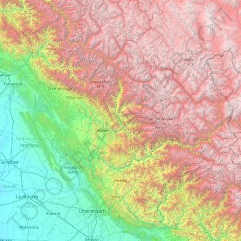
Name: Himachal Pradesh topographic map, elevation, terrain.
Location: Himachal Pradesh, India (30.37717 75.59401 33.25567 79.01238)
Average elevation: 2,869 m
Minimum elevation: 232 m
Maximum elevation: 6,687 m
Due to extreme variation in elevation, great variation occurs in the climatic conditions of Himachal. The climate varies from hot and humid subtropical in the southern tracts to, with more elevation, cold, alpine, and glacial in the northern and eastern mountain ranges. The state's winter capital, Dharamsala receives very heavy rainfall, while areas like Lahaul and Spiti are cold and almost rainless. Broadly, Himachal experiences three seasons: summer, winter, and rainy season. Summer lasts from mid-April till the end of June and most parts become very hot (except in the alpine zone which experiences a mild summer) with the average temperature ranging from 28 to 32 °C (82 to 90 °F). Winter lasts from late November till mid-March. Snowfall is common in alpine tracts. Pollution is affecting the climate of almost all the states of India. Due to steps taken by governments to prevent pollution, Himachal Pradesh has become the first smoke-free state in India which means cooking in the entire state is free of traditional chulhas.
Other topographic maps
Click on a map to view its topography, its elevation and its terrain.
Bengaluru
India > Karnataka > Bangalore North
Bengaluru, Bangalore North, Bengaluru Urban District, Karnataka, India
Average elevation: 881 m
Chennai
India > Tamil Nadu > Chennai
Chennai, Chennai District, Tamil Nadu, India
Average elevation: 8 m
Manapparai
India > Tamil Nadu > Manapparai
Manapparai, Tiruchirappalli District, Tamil Nadu, 621306, India
Average elevation: 161 m
Kolkata
Kolkata, Kolkata District, West Bengal, 700073, India
Average elevation: 5 m
3d
India > Rajasthan > Ganganagar Tehsil > 1 LNP
3d, 1 LNP, Ganganagar Tehsil, Sri Ganganagar District, Rajasthan, India
Average elevation: 178 m
Western Ghats
Western Ghats, Idukki, Kerala, 685614, India
Average elevation: 2,225 m
Thiruvananthapuram
India > Kerala > Thiruvananthapuram
Thiruvananthapuram, Thiruvananthapuram District, Kerala, 695001, India
Average elevation: 33 m
Pune
India > Maharashtra > Pune City > Pune
Pune, Pune City, Pune District, Maharashtra, 411001, India
Average elevation: 641 m
Karaikudi
India > Tamil Nadu > Karaikkudi
Karaikudi, Karaikkudi, Sivagangai District, Tamil Nadu, 623001, India
Average elevation: 87 m
Mysuru
India > Karnataka > Mysuru taluk
Mysuru, Mysuru taluk, Mysuru District, Karnataka, 570001, India
Average elevation: 727 m
Rampur Bushahr
India > Himachal Pradesh > Rampur
Rampur Bushahr, Rampur, Shimla district, Himachal Pradesh, India
Average elevation: 1,715 m
Patna
India > Bihar > Patna Rural
Patna, Patna Rural, Patna District, Bihar, 800001, India
Average elevation: 51 m
Sengarai
India > Tamil Nadu > KOLLI HILLS
Sengarai, KOLLI HILLS, Namakkal District, Tamil Nadu, 637411, India
Average elevation: 1,060 m
Anaikkattu
India > Tamil Nadu > Vellore
Anaikkattu, Vellore, Vellore District, Tamil Nadu, 632101, India
Average elevation: 272 m
Gudiyatham
India > Tamil Nadu > Gudiyatham
Gudiyatham, Vellore District, Tamil Nadu, 635803, India
Average elevation: 294 m
Pernampattu
India > Tamil Nadu > Gudiyatham
Pernampattu, Gudiyatham, Vellore District, Tamil Nadu, 635810, India
Average elevation: 425 m
Arasur
India > Tamil Nadu > Thiruvennainallur
Arasur, Thiruvennainallur, Viluppuram District, Tamil Nadu, India
Average elevation: 51 m
Thandrampet
Thandrampet, Tiruvannamalai District, Tamil Nadu, India
Average elevation: 258 m
Vaniyambadi
Vaniyambadi, Tirupattur District, Tamil Nadu, India
Average elevation: 559 m
Natrampalli
India > Tamil Nadu > Tirupathur
Natrampalli, Tirupathur, Tirupattur District, Tamil Nadu, 635852, India
Average elevation: 438 m
Pandarapuram
India > Tamil Nadu > Sathankulam
Pandarapuram, Sathankulam, Thoothukudi District, Tamil Nadu, 628704, India
Average elevation: 35 m
Marungapuri
India > Tamil Nadu > Manapparai
Marungapuri, Manapparai, Tiruchirappalli District, Tamil Nadu, India
Average elevation: 249 m
Periyar River
India > Kerala > Paravur > Edayar
Periyar River, Njaarakkaattu, Edayar, Paravur, Ernakulam District, Kerala, India
Average elevation: 8 m
Rampur
India > Odisha > Madanpur Rampur
Rampur, Madanpur Rampur, Kalahandi District, Odisha, 766112, India
Average elevation: 211 m