
Punjab topographic map
Interactive map
Click on the map to display elevation.
About this map
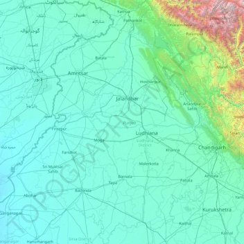
Name: Punjab topographic map, elevation, terrain.
Location: Punjab, India (29.54294 73.87983 32.51118 76.93906)
Average elevation: 477 m
Minimum elevation: 170 m
Maximum elevation: 6,027 m
Punjab is in northwestern India and has a total area of 50,362 square kilometres (19,445 sq mi). Punjab is bordered by Pakistan's Punjab province on the west, Jammu and Kashmir on the north, Himachal Pradesh on the northeast and Haryana and Rajasthan on the south. Most of Punjab lies in a fertile, alluvial plain with perennial rivers and an extensive irrigation canal system. A belt of undulating hills extends along the northeastern part of the state at the foot of the Himalayas. Its average elevation is 300 metres (980 ft) above sea level, with a range from 180 metres (590 ft) in the southwest to more than 500 metres (1,600 ft) around the northeast border. The southwest of the state is semi-arid, eventually merging into the Thar Desert. Of the five Punjab rivers, three—Sutlej, Beas and Ravi—flow through the Indian state. The Sutlej and Ravi define parts of the international border with Pakistan.
Other topographic maps
Click on a map to view its topography, its elevation and its terrain.
Bengaluru
India > Karnataka > Bangalore North
Bengaluru, Bangalore North, Bengaluru Urban District, Karnataka, India
Average elevation: 881 m
Chennai
India > Tamil Nadu > Chennai
Chennai, Chennai District, Tamil Nadu, India
Average elevation: 8 m
3d
India > Rajasthan > Ganganagar Tehsil > 1 LNP
3d, 1 LNP, Ganganagar Tehsil, Sri Ganganagar District, Rajasthan, India
Average elevation: 178 m
Pune
India > Maharashtra > Pune City > Pune
Pune, Pune City, Pune District, Maharashtra, 411001, India
Average elevation: 641 m
Dholka
India > Madhya Pradesh > Ratlam Tahsil
Dholka, Ratlam Tahsil, Ratlam District, Madhya Pradesh, India
Average elevation: 467 m
musi
India > Telangana > Balanagar mandal > Hyderabad
musi, Greater Hyderabad Municipal Corporation North Zone, Hyderabad, Balanagar mandal, Medchal–Malkajgiri District, Telangana, India
Average elevation: 524 m
Manapparai
India > Tamil Nadu > Manapparai
Manapparai, Tiruchirappalli District, Tamil Nadu, 621306, India
Average elevation: 161 m
Tehri-Garhwal
Tehri-Garhwal, Tehri Garhwal District, Uttarakhand, 249125, India
Average elevation: 2,339 m
Patna
India > Bihar > Patna Rural
Patna, Patna Rural, Patna District, Bihar, 800001, India
Average elevation: 51 m
Kolkata
Kolkata, Kolkata District, West Bengal, 700073, India
Average elevation: 5 m
Harapanahalli
India > Karnataka > Harapanahalli taluku
Harapanahalli, Harapanahalli taluku, Vijayanagara District, Karnataka, 583131, India
Average elevation: 626 m
Kwatha Meitei
India > Manipur > Tengnoupal tehsil
Kwatha Meitei, Tengnoupal tehsil, Tengnoupal District, Manipur, India
Average elevation: 476 m
Sengarai
India > Tamil Nadu > KOLLI HILLS
Sengarai, KOLLI HILLS, Namakkal District, Tamil Nadu, 637411, India
Average elevation: 1,060 m
Anaikkattu
India > Tamil Nadu > Vellore
Anaikkattu, Vellore, Vellore District, Tamil Nadu, 632101, India
Average elevation: 272 m
Gudiyatham
India > Tamil Nadu > Gudiyatham
Gudiyatham, Vellore District, Tamil Nadu, 635803, India
Average elevation: 294 m
Pernampattu
India > Tamil Nadu > Gudiyatham
Pernampattu, Gudiyatham, Vellore District, Tamil Nadu, 635810, India
Average elevation: 425 m
Arasur
India > Tamil Nadu > Thiruvennainallur
Arasur, Thiruvennainallur, Viluppuram District, Tamil Nadu, India
Average elevation: 51 m
Thandrampet
Thandrampet, Tiruvannamalai District, Tamil Nadu, India
Average elevation: 258 m
Vaniyambadi
Vaniyambadi, Tirupattur District, Tamil Nadu, India
Average elevation: 559 m
Natrampalli
India > Tamil Nadu > Tirupathur
Natrampalli, Tirupathur, Tirupattur District, Tamil Nadu, 635852, India
Average elevation: 438 m
Pandarapuram
India > Tamil Nadu > Sathankulam
Pandarapuram, Sathankulam, Thoothukudi District, Tamil Nadu, 628704, India
Average elevation: 35 m
Marungapuri
India > Tamil Nadu > Manapparai
Marungapuri, Manapparai, Tiruchirappalli District, Tamil Nadu, India
Average elevation: 249 m
Periyar River
India > Kerala > Paravur > Edayar
Periyar River, Njaarakkaattu, Edayar, Paravur, Ernakulam District, Kerala, India
Average elevation: 8 m
Rampur
India > Odisha > Madanpur Rampur
Rampur, Madanpur Rampur, Kalahandi District, Odisha, 766112, India
Average elevation: 211 m
Nanded
India > Maharashtra > Nanded
Nanded, Nanded District, Maharashtra, 431600, India
Average elevation: 376 m