
Bihar topographic map
Interactive map
Click on the map to display elevation.
About this map
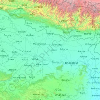
Name: Bihar topographic map, elevation, terrain.
Location: Bihar, India (24.28572 83.32126 27.52164 88.29823)
Average elevation: 606 m
Minimum elevation: 11 m
Maximum elevation: 8,419 m
Bihar covers a total area of 94,163 km2 (36,357 sq mi), with an average elevation above sea level of 173 feet (53 m). It is land locked by Nepal in the north, Jharkhand in the south West Bengal in the east and Uttar Pradesh to the west. It has three parts on the basis of physical and structural conditions: the Southern Plateau, the Shivalik Region, and Bihar's Gangetic Plain. Furthermore, the vast stretch of fertile Bihar Plain is divided by the Ganges River into two unequal parts – North Bihar and South Bihar. The Ganges flows west–east and, along with its tributaries, regularly floods parts of the Bihar plain. The main northern tributaries are the Gandak and Koshi, which originate in the Nepalese Himalayas, and the Bagmati, which originates in the Kathmandu Valley. Other tributaries are the Son, Budhi Gandak, Chandan, Orhani and Phalgu. Bihar has some small hills, such as the Rajgir hills in center, Kaimur Range in south-west and Shivalik Range in North. Bihar has notified forest area of 6,764.14 km2, which is 7.1 percent of its geographical area. The sub-Himalayan foothills of Shivalik ranges, primary Someshwar and Dun mountain, in West Champaran district are clad in a belt of moist deciduous forest. As well as trees, this consists of scrub, grass and reeds.
Other topographic maps
Click on a map to view its topography, its elevation and its terrain.
Bengaluru
India > Karnataka > Bangalore North
Bengaluru, Bangalore North, Bengaluru Urban District, Karnataka, India
Average elevation: 881 m
Chennai
India > Tamil Nadu > Chennai
Chennai, Chennai District, Tamil Nadu, India
Average elevation: 8 m
3d
India > Rajasthan > Ganganagar Tehsil > 1 LNP
3d, 1 LNP, Ganganagar Tehsil, Sri Ganganagar District, Rajasthan, India
Average elevation: 178 m
Pune
India > Maharashtra > Pune City > Pune
Pune, Pune City, Pune District, Maharashtra, 411001, India
Average elevation: 641 m
Srinagar
India > Jammu and Kashmir > Srinagar (South)
Srinagar, Srinagar (South), Srinagar District, Jammu and Kashmir, 190001, India
Average elevation: 1,805 m
Jaipur
India > Rajasthan > Jaipur Tehsil
Jaipur, Jaipur Municipal Corporation, Jaipur Tehsil, Jaipur District, Rajasthan, 302001, India
Average elevation: 408 m
Dholka
India > Madhya Pradesh > Ratlam Tahsil
Dholka, Ratlam Tahsil, Ratlam District, Madhya Pradesh, India
Average elevation: 467 m
musi
India > Telangana > Balanagar mandal > Hyderabad
musi, Greater Hyderabad Municipal Corporation North Zone, Hyderabad, Balanagar mandal, Medchal–Malkajgiri District, Telangana, India
Average elevation: 524 m
Manapparai
India > Tamil Nadu > Manapparai
Manapparai, Tiruchirappalli District, Tamil Nadu, 621306, India
Average elevation: 161 m
Tehri-Garhwal
Tehri-Garhwal, Tehri Garhwal District, Uttarakhand, 249125, India
Average elevation: 2,339 m
Patna
India > Bihar > Patna Rural
Patna, Patna Rural, Patna District, Bihar, 800001, India
Average elevation: 51 m
Kolkata
Kolkata, Kolkata District, West Bengal, 700073, India
Average elevation: 5 m
Harapanahalli
India > Karnataka > Harapanahalli taluku
Harapanahalli, Harapanahalli taluku, Vijayanagara District, Karnataka, 583131, India
Average elevation: 626 m
Kwatha Meitei
India > Manipur > Tengnoupal tehsil
Kwatha Meitei, Tengnoupal tehsil, Tengnoupal District, Manipur, India
Average elevation: 476 m
Sengarai
India > Tamil Nadu > KOLLI HILLS
Sengarai, KOLLI HILLS, Namakkal District, Tamil Nadu, 637411, India
Average elevation: 1,060 m
Anaikkattu
India > Tamil Nadu > Vellore
Anaikkattu, Vellore, Vellore District, Tamil Nadu, 632101, India
Average elevation: 272 m
Gudiyatham
India > Tamil Nadu > Gudiyatham
Gudiyatham, Vellore District, Tamil Nadu, 635803, India
Average elevation: 294 m
Pernampattu
India > Tamil Nadu > Gudiyatham
Pernampattu, Gudiyatham, Vellore District, Tamil Nadu, 635810, India
Average elevation: 425 m
Arasur
India > Tamil Nadu > Thiruvennainallur
Arasur, Thiruvennainallur, Viluppuram District, Tamil Nadu, India
Average elevation: 51 m
Thandrampet
Thandrampet, Tiruvannamalai District, Tamil Nadu, India
Average elevation: 258 m
Vaniyambadi
Vaniyambadi, Tirupattur District, Tamil Nadu, India
Average elevation: 559 m
Natrampalli
India > Tamil Nadu > Tirupathur
Natrampalli, Tirupathur, Tirupattur District, Tamil Nadu, 635852, India
Average elevation: 438 m
Pandarapuram
India > Tamil Nadu > Sathankulam
Pandarapuram, Sathankulam, Thoothukudi District, Tamil Nadu, 628704, India
Average elevation: 35 m
Marungapuri
India > Tamil Nadu > Manapparai
Marungapuri, Manapparai, Tiruchirappalli District, Tamil Nadu, India
Average elevation: 249 m