
Kawempe topographic map
Interactive map
Click on the map to display elevation.
About this map
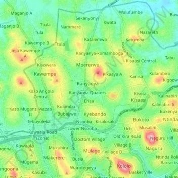
Name: Kawempe topographic map, elevation, terrain.
Location: Kawempe, Kampala, Central Region, Uganda (0.32904 32.54980 0.40364 32.60358)
Average elevation: 1,196 m
Minimum elevation: 1,141 m
Maximum elevation: 1,308 m
Other topographic maps
Click on a map to view its topography, its elevation and its terrain.
Kikandwa
Uganda > Central Region > Kampala
Kikandwa, Kampala, Central Region, Uganda
Average elevation: 1,191 m
Isreal-matovu
Uganda > Central Region > Kampala
Isreal-matovu, Kampala, Central Region, Uganda
Average elevation: 1,187 m
Bahai
Uganda > Central Region > Kampala
Bahai, Kawempe, Kampala, Central Region, Uganda
Average elevation: 1,200 m
Rubaga
Uganda > Central Region > Kampala
Rubaga, Kampala, Central Region, Uganda
Average elevation: 1,187 m
Central
Uganda > Central Region > Kampala
Central, Kampala, Central Region, Uganda
Average elevation: 1,193 m